Fort Sisseton
|
Fort Sisseton | |
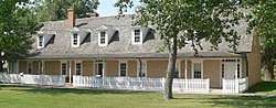 Officers' quarters, photographed 2017 | |
  | |
| Nearest city | Britton, South Dakota |
|---|---|
| Coordinates | 45°39′28″N 97°31′50″W / 45.65778°N 97.53056°WCoordinates: 45°39′28″N 97°31′50″W / 45.65778°N 97.53056°W |
| Area | 35 acres (14 ha) |
| Built | 1864 |
| NRHP reference # | 73001745[1] |
| Added to NRHP | May 10, 1973 |
Fort Sisseton near Britton, South Dakota was established in 1864. As Fort Sisseton Historic State Park, it was designated as a State Historical Park in 1959.[2] Fort Sisseton is listed on the U.S. National Register of Historic Places.[1]
It has 14 of its original buildings remaining.[2]
The fort with 35 acres (14 ha) was listed on the National Register in 1973. The listing included 15 contributing buildings and 9 contributing sites.[1][3] Fort Sisseton State Park has a festival the first weekend of June each year with entertainment and reenacting of fort activities. https://travel.campsd.com/campgrounds-and-rv-parks/all/fort-sisseton-state-park/overview
References
- 1 2 3 National Park Service (2010-07-09). "National Register Information System". National Register of Historic Places. National Park Service.
- 1 2 Thune, John R. "Fort Sisseton". Local Legacies. Library of Congress. Retrieved 2008-12-21.
- ↑ "Fort Sisseton Historic State Park". State of South Dakota. Retrieved 2012-07-25.
External links
| Wikimedia Commons has media related to Fort Sisseton State Park (South Dakota). |
- Fort Sisseton Historical Park - official site
| Topics | |
|---|---|
| Lists by states |
|
| Lists by insular areas | |
| Lists by associated states | |
| Other areas | |
| |
This article is issued from
Wikipedia.
The text is licensed under Creative Commons - Attribution - Sharealike.
Additional terms may apply for the media files.