Flower's Cove
| Flower's Cove | |
|---|---|
| Town | |
 Flower's Cove Location of Flower's Cove in Newfoundland | |
| Coordinates: 51°17′0″N 56°44′0″W / 51.28333°N 56.73333°W | |
| Country |
|
| Province |
|
| Population (2016) | |
| • Total | 270 |
| Time zone | UTC-3:30 (Newfoundland Time) |
| • Summer (DST) | UTC-2:30 (Newfoundland Daylight) |
| Area code(s) | 709 |
 | |
| Location |
Flower's Cove Newfoundland Canada |
|---|---|
| Coordinates | 48°27′26.06″N 58°29′19.34″W / 48.4572389°N 58.4887056°W |
| Year first constructed | 1899 (first) |
| Year first lit | 1969 (current) |
| Deactivated | 1969 |
| Foundation | concrete base (current) |
| Construction |
woody tower (first) metal skeletal tower (current) |
| Tower shape |
quadrangular atop the keeper’s house with balcony and lantern (first) square pyramidal skeletal tower with balcony and light (current) |
| Markings / pattern |
white tower (first) grey metal skeletal tower (current) |
| Height |
15.5 metres (51 ft) (first) 4 metres (13 ft) (current) |
| Focal height | 5 metres (16 ft) (current) |
| Light source | mains power |
| Range | 4 nautical miles (7.4 km; 4.6 mi) |
| Characteristic | Fl G 3s. |
| Admiralty number | H0144 |
| CHS number | CCG 213 |
| NGA number | 2724 |
| ARLHS number | CAN-657 |
| Managing agent | Town of Flower's Cove[1][2][3] |
Flower's Cove is a town in the Canadian province of Newfoundland and Labrador. The town had a population of 270 in the Canada 2006 Census. It is known for its thrombolite fossils.
Sights
Flower's Cove is famous for thrombolites, very rare fossils which can be seen on the coast in the southern part of the town, remnants of bacteria and algae. They are about 650 million years old. The only places where thrombolites were found are Flower's Cove and Western Australia.[4]
There are three churches in Flower's Cove, the most famous and largest of which is St. Barnabas Anglican Church. It is known as Skin Boot Church, as leather shoes were sold for the church fund when the church was built in the 1920s. Flower's Cove United Church is the smallest. It has a flèche instead of a spire.
Marjorie Bridge is a red-roofed bridge dating from the beginning of the 20th century.[5] It is close to the Roman Catholic Church Lady of Snow, which is more than 100 years old. The church was renovated in 2007. It is a part of Our Lady of Grace Parish in Bird Cove, which belongs to the diocese of St. George.
Gallery
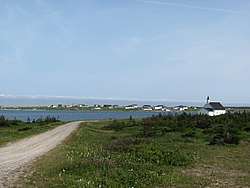
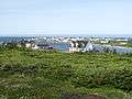 General view of the town
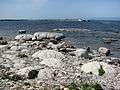 Thrombolites
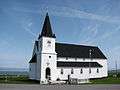 St. Barnabas Anglican Church
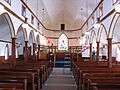 St. Barnabas Anglican Church
- United Church
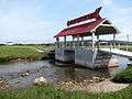 Marjorie Bridge
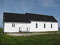 Catholic Church Lady of Snow
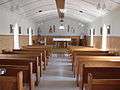 Catholic Church Lady of Snow
See also
Climate
| Climate data for Flowers Cove 1981 to 2010 Canadian Climate Normals station data | |||||||||||||
|---|---|---|---|---|---|---|---|---|---|---|---|---|---|
| Month | Jan | Feb | Mar | Apr | May | Jun | Jul | Aug | Sep | Oct | Nov | Dec | Year |
| Record high °C (°F) | 12.0 (53.6) |
12.0 (53.6) |
10.0 (50) |
17.0 (62.6) |
25.0 (77) |
24.0 (75.2) |
25.0 (77) |
26.0 (78.8) |
24.5 (76.1) |
20.0 (68) |
17.0 (62.6) |
11.0 (51.8) |
26 (78.8) |
| Average high °C (°F) | −6.5 (20.3) |
−7.0 (19.4) |
−2.3 (27.9) |
2.2 (36) |
7.3 (45.1) |
12.2 (54) |
16.6 (61.9) |
17.3 (63.1) |
13.7 (56.7) |
7.7 (45.9) |
2.6 (36.7) |
−2.4 (27.7) |
5.1 (41.2) |
| Daily mean °C (°F) | −10.8 (12.6) |
−11.4 (11.5) |
−6.2 (20.8) |
−1.0 (30.2) |
3.7 (38.7) |
7.9 (46.2) |
12.5 (54.5) |
13.4 (56.1) |
9.8 (49.6) |
4.4 (39.9) |
−0.4 (31.3) |
−5.8 (21.6) |
1.3 (34.4) |
| Average low °C (°F) | −15.5 (4.1) |
−15.8 (3.6) |
−10.2 (13.6) |
−4.2 (24.4) |
0.1 (32.2) |
3.7 (38.7) |
8.4 (47.1) |
9.5 (49.1) |
5.9 (42.6) |
1.1 (34) |
−3.5 (25.7) |
−9.3 (15.3) |
−2.5 (27.5) |
| Record low °C (°F) | −30.0 (−22) |
−34.0 (−29.2) |
−31.0 (−23.8) |
−21.0 (−5.8) |
−9.0 (15.8) |
−4.0 (24.8) |
−1.0 (30.2) |
2.0 (35.6) |
−2.0 (28.4) |
−9.0 (15.8) |
−18.0 (−0.4) |
−29.0 (−20.2) |
−34 (−29.2) |
| Average precipitation mm (inches) | 87.9 (3.461) |
70.8 (2.787) |
71.9 (2.831) |
56.4 (2.22) |
76.1 (2.996) |
106.5 (4.193) |
107.6 (4.236) |
102.3 (4.028) |
99.2 (3.906) |
96.5 (3.799) |
79.3 (3.122) |
84.7 (3.335) |
1,039.2 (40.914) |
| Average rainfall mm (inches) | 16.0 (0.63) |
12.4 (0.488) |
21.8 (0.858) |
31.0 (1.22) |
70.4 (2.772) |
105.9 (4.169) |
107.6 (4.236) |
102.3 (4.028) |
99.2 (3.906) |
94.0 (3.701) |
65.6 (2.583) |
36.6 (1.441) |
762.8 (30.032) |
| Average snowfall cm (inches) | 72 (28.3) |
58 (22.8) |
50 (19.7) |
25 (9.8) |
6 (2.4) |
1 (0.4) |
0 (0) |
0 (0) |
0 (0) |
3 (1.2) |
14 (5.5) |
48 (18.9) |
277 (109) |
| Average precipitation days (≥ 0.2 mm) | 13.2 | 12.4 | 11.4 | 11.2 | 12.7 | 15.1 | 15.1 | 14.6 | 14.6 | 15.5 | 14.3 | 13.8 | 163.9 |
| Average rainy days (≥ 0.2 mm) | 2.4 | 2.5 | 3.6 | 6.3 | 11.7 | 15.0 | 15.1 | 14.6 | 14.6 | 15.2 | 10.1 | 4.3 | 115.4 |
| Average snowy days (≥ 0.2 cm) | 11.7 | 10.6 | 8.3 | 4.9 | 1.0 | 0.13 | 0 | 0 | 0 | 0.48 | 3.9 | 9.5 | 50.51 |
| Source: Environment Canada[6] | |||||||||||||
References
- ↑ Central and Western Newfoundland The Lighthouse Directory. University of North Carolina at Chapel Hill. Retrieved 15 February 2017
- ↑ Flower's Cove Lighthouse Friends. Retrieved 15 February 2017
- ↑ List of Lights, Pub. 110: Greenland, The East Coasts of North and South America (Excluding Continental U.S.A. Except the East Coast of Florida) and the West Indies (PDF). List of Lights. United States National Geospatial-Intelligence Agency. 2016.
- ↑ Andrew Hampstead: Atlantic Canada, p. 380. Berkeley CA 2012.
- ↑ Andrew Hampstead: Atlantic Canada, p. 379. Berkeley CA 2012.
- ↑ http://climate.weather.gc.ca/climate_normals/results_1981_2010_e.html?stnID=6624&lang=e&province=NL&provSubmit=go&dCode=0
Coordinates: 51°17′57.42″N 56°43′42.39″W / 51.2992833°N 56.7284417°W
External links
| Wikimedia Commons has media related to Flower's Cove. |
- Aids to Navigation Canadian Coast Guard
| Towns |
|  |
|---|---|---|
| Unorganized subdivisions |
| |