Trout River, Newfoundland and Labrador
| Trout River | |
|---|---|
| Town | |
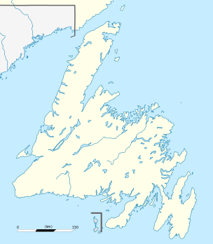 Trout River Location of Trout River in Newfoundland | |
| Coordinates: 49°29′52.46″N 58°07′32.38″W / 49.4979056°N 58.1256611°W | |
| Country |
|
| Province |
|
| Settled | 1815 |
| Incorporated | 1966 |
| Government | |
| • Mayor | Gloria Barnes |
| Population (2016) | |
| • Total | 552 |
| Time zone | UTC– 3:30 (Newfoundland Time) |
| • Summer (DST) | UTC– 2:30 (Newfoundland Daylight) |
| Area code(s) | 709 |
| Website | http://townoftroutriver.com |
Trout River is a small rural fishing village located on the southern coastal edge of Gros Morne National Park in Newfoundland. Trout River was settled in 1815 by George Crocker and his family, who were its only inhabitants until 1880.[1][2][3] The community is served by Route 431.
There is a large natural tower of rock, a sea stack, just south of the town.[4]
See also
References
- ↑ Joan Edward (2006). "This is Our Place, this is Our Home". Breakwater Books. p. 191-205. ISBN 9781550812015. Retrieved 2017-05-01.
- ↑ "Trout River". k12.nf.ca. Archived from the original on 2017-05-01.
- ↑ Trout River, Newfoundland and Labrador
- ↑
Jim Cornish. "Natural History of Newfoundland and Labrador: Geological Formation" (PDF). k12.nf.ca. Retrieved 2017-05-01.
Today, there are many places along the coast of Newfoundland where beaches and sea stacks, like the one at Trout River in Gros Morne National Park pictured above, are 20 to 100 metres above present sea level.
Coordinates: 49°29′52.46″N 58°07′32.38″W / 49.4979056°N 58.1256611°W
| Towns |
|  |
|---|---|---|
| Unorganized subdivisions |
| |
This article is issued from
Wikipedia.
The text is licensed under Creative Commons - Attribution - Sharealike.
Additional terms may apply for the media files.