Kela Alon
| Kela Alon קלע אלון | |
|---|---|
 | |
 Kela Alon  Kela Alon | |
| Coordinates: 33°7′55″N 35°41′11″E / 33.13194°N 35.68639°ECoordinates: 33°7′55″N 35°41′11″E / 33.13194°N 35.68639°E | |
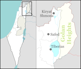
| District | Northern |
| Council | Golan |
| Region | Golan Heights |
| Affiliation | Mishkei Herut Beitar |
| Founded |
1981 (original) 1991 (re-establishment) |
| Population (2017)[1] | 277 |
Kela Alon (Hebrew: קלע אלון) is an Israeli settlement organized as a community settlement, in the Golan Heights. Falling under the municipal jurisdiction of Golan Regional Council, in 2017 it had a population of 277.[1]
The international community considers Israeli settlements in the Golan Heights illegal under international law, but the Israeli government disputes this.[2]
History
Until its depopulation in 1967, the site was occupied by the Syrian village of Qanaabé (Kana'beh), which had about 480 inhabitants.[3] The area was settled by Israelis in 1981 and was initially a Nahal settlement. However, the close distance to army regions as well as presence of landmines caused its abandonment at 1988. The modern settlement was founded in 1991 and was initially called 'Bruchim' (Hebrew: ברוכים). The first settlers there were immigrants from the Soviet Union.[4] The current name was adopted in 1997.[5][6] A new neighborhood was built in 2003, also known as Mazok Orvim (Hebrew: מצוק עורבים).
See also
References
- 1 2 "List of localities, in Alphabetical order" (PDF). Israel Central Bureau of Statistics. Retrieved August 26, 2018.
- ↑ "The Geneva Convention". BBC. 10 December 2009.
- ↑ Yigal Kipnis (2013). The Golan Heights Political history, settlement and geography since 1949. Routledge. p. 243.
- ↑ "U.S. ASKS PAUSE IN MIDEAST TALKS GOLAN HEIGHTS SORE POINT". timesunion.com. November 5, 1991. Archived from the original on February 23, 2013. Retrieved August 29, 2012.
- ↑ http://www.golan.org.il/553/417.htm
- ↑ http://www.golan.org.il/831/1789.htm