Lower Clapton
| Lower Clapton | |
|---|---|
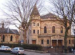 Lower Clapton's unusual Round Chapel. Built in 1869–71 as a Congregational church, it is now an arts centre. It is considered to be one of the finest non-conformist buildings in London. | |
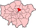
 Lower Clapton Lower Clapton shown within Greater London | |
| OS grid reference | TQ355855 |
| • Charing Cross | 5 mi (8.0 km) SW |
| London borough | |
| Ceremonial county | Greater London |
| Region | |
| Country | England |
| Sovereign state | United Kingdom |
| Post town | LONDON |
| Postcode district | E5 |
| Dialling code | 020 |
| Police | Metropolitan |
| Fire | London |
| Ambulance | London |
| EU Parliament | London |
| UK Parliament | |
| London Assembly | |
Lower Clapton /ˈklæptən/ is a district of East London[1] in the London Borough of Hackney, lying immediately north of Hackney Central, the borough's administrative and retail centre.
Lower Clapton can be described as closely approximating to the southern part of the E5 (Clapton) postal district.
Bounds
Lower Clapton closely approximates to the southern part of the E5 (Clapton) postal district and as such can be described as having the following approximate boundaries:
- North: Lea Bridge Road\Kenninghall Road. Upper Clapton lies north of these roads.
Manorial courts from the early 19th century distinguished the parts of Clapton north and south of Lea Bridge Road as Upper and Lower Clapton, and those names soon passed into general use.
- West: The Rectory Road to Hackney Downs rail line (though both stations are just outside Clapton), taking in Hackney Downs park.
- East: The Lea Valley.
- South: The southern boundary approximates to Clifden Road.
History
Clapton was from 1339 until the 18th century normally rendered as Clopton, meaning the "farm on the hill". The Old English clop - "lump" or "hill" - presumably denoted the high ground which rises from the River Lea. Clapton grew up as a straggling hamlet along the road subsequently known as Lower and Upper Clapton Road, and as the area became urbanised, the extent of the area called Clapton eventually increased to encompass most of the north-eastern quarter of the Ancient Parish and subsequent Metropolitan Borough of Hackney.
As described, the settlement emerged along the way which in 1745 was called Hackney Lane, part of which ran through Broad (later Clapton) Common. Building spread to meet streets east of the high road and north of Homerton in the 19th century. Manorial courts (the Manor of Lordship) from the early 19th century distinguished the parts north and south of Lea Bridge Road as Upper and Lower Clapton, and those names soon passed into general use. Hackney Lane came to be known as Lower and Upper Clapton roads, until in the late 19th century the stretch through the common to Stamford Hill was named Clapton Common.[2]
Open Spaces and Urban Fabric
Lower Clapton is centred on Lower Clapton Road, to the north of which is Clapton Pond, the remnant of the old village green.
Clapton Pond and the late Georgian Clapton Square are the area's two major conservation zones. Clapton Square is an attractive Conservation area which includes historic Georgian terraces facing onto the parkland in the centre of the Square.
Hackney Downs, one of the larger open spaces in Hackney, is formally within this district, though many people consider the Downs to be an area of Hackney in its own right.
Lower Clapton has a relatively large amount of green space for a district of inner London. In addition to Hackney Downs, the area is bordered by Millfields Park, Clapton Park, and Hackney Marshes.

Large parts of Lower Clapton look much as they did when the area was first developed in the second half of the 19th century. Most of the housing stock consists of Victorian terraces of various sizes. Several highrise LPS constructions erected by the Council in the late 1960s and early 1970s were demolished in the 1990s to make way for lowrise Local Authority housing, e.g. the Clapton Park Estate.
Social Fabric
Like many other parts of East London, Lower Clapton is socially diverse and multicultural. Chatsworth Road, which had a regular market until the 1990s, still provides many amenities for people who live in the area. A new Sunday market has been established there since December 2010. The shops and restaurants on Chatsworth Road reflect the diversity of the surrounding streets – offering African, Turkish, Asian and Caribbean produce alongside butchers, bakers and greengrocers. More recent additions include a creperie, coffee shops and a French delicatessen, part of the area's vaunted gentrification in the lead-up to the 2012 Olympic Games.
Governance and Representation
As of 2014, Lower Clapton is represented by five separate electoral wards. Each of these wards straddles the boundaries between Lower Clapton and its neighbours.
Lower Clapton is split between two parliamentary constituencies: Hackney North and Stoke Newington, and Hackney South and Shoreditch.
Notable people
Notable residents have included John Howard, Nathaniel Woodard who was a curate of St. John's, Harold Pinter, Helen Shapiro and Jessica Tandy.
A number of shootings that took place in the 1990s and early 2000s on Upper and Lower Clapton Road earned the locality the nickname "Murder Mile".[3] During the 2011 England riots, Clarence Road, near the epicentre of the rioting, was the site of Pauline Pearce's Heroine of Hackney speech.[4]
Education
Secondary schools in the area include Clapton Girls' Academy and Mossbourne Community Academy. Mossbourne is located on the site of the former Hackney Downs School. Millfields Community School is regularly said to be one of the most improved schools in the country and was visited by Tony Blair in 2005 [5]
Sport
Clapton F.C. was the original local football team, being formed in 1878. Leyton Orient, founded in 1881 also played in the area before moving to Leyton in 1937.
Transport
Lower Clapton doesn't contain any railway stations but there are a number close by, including:
- Clapton (in Upper Clapton)
- Hackney Central
- Homerton
- Rectory Road (in Stoke Newington)
- Hackney Downs (on the edge of the Hackney Central and Dalston areas).
Neighbouring areas of London | ||||||||||
|---|---|---|---|---|---|---|---|---|---|---|
| ||||||||||
References
- ↑ "London Places" (PDF). Greater London Authority. GLA. Archived from the original (PDF) on 6 September 2015. Retrieved 11 October 2015.
- ↑ 'Hackney: Clapton', A History of the County of Middlesex. 10. 1995. pp. 44–51. Retrieved 2011-05-17.
- ↑ Thompson, Tony (2001-04-22). "Two more die on 'murder mile'". The Guardian. Retrieved 2011-05-17.
- ↑ "Hackney 2011: the year that was". Hackney Citizen. 7 January 2012. Retrieved 17 January 2012.
The Pembury Estate in Central Hackney was the epicentre of the pillaging and burning that raged down Clarence Road, Narroway and Mare Street [...]
- ↑ Kenny, Ursula. "Ursula Kenny on how Anna Hassan turned around Millfields primary school in Hackney". the Guardian. Retrieved 2015-09-02.
External links
- The Round Chapel Auditorium
- Clapton from British History Online
- Clapton Pond Neighbourhood Action Group
| Districts |
|  |
|---|---|---|
| Attractions | ||
| Parks, rivers and open spaces |
| |
| Street markets | ||
| Pubs | ||
| Places of worship | ||
| Parliamentary constituencies | ||
| Tube and rail stations | ||
| Other topics | ||