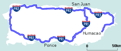
Puerto Rico Highway 18
| ||||
|---|---|---|---|---|
| Expreso Las Américas | ||||
 | ||||
| Route information | ||||
| Maintained by Puerto Rico Dept. of Transportation and Public Works (DTOP) | ||||
| Existed | 1960's and rebuilt in late 90's – present | |||
| Major junctions | ||||
| North end |
| |||
|
| ||||
| South end |
| |||
| Highway system | ||||
| ||||

PR-18 is a freeway in Puerto Rico, which is also known as Expreso Las Américas. It runs from its north end in at its intersection with PR-22 (known as Expreso de Diego) in San Juan to its south end in Río Piedras where it intersects with PR-1. At this point PR-18 becomes PR-52, known as Autopista Luis A. Ferré.
Route description
PR-18 begins from PR-22
PR-18 connects PR-52 to PR-22 and intersects with Jesus de Piñero Avenue (PR-17), Franklin Delano Roosevelt Avenue (PR-23), which grants access to Plaza Las Américas, and Domenech Avenue. It is mostly a 4-lane road in each direction. The combined route of PR-18 and PR-52 is coterminous with the unsigned Interstate Highway PRI-1.
Exit list
| Municipality | Location | km | mi | Exit | Destinations | Notes |
|---|---|---|---|---|---|---|
| San Juan | 0.0 | 0.0 | 0 | North end of PR-18 and PRI-1, access to Luis Muñoz Marín International Airport | ||
| 3A-C | Frontage roads of these exits has an at-grade intersection in Chardon Street; Access to Plaza Las Americas shopping mall and Roosevelt station | |||||
| 4 | Access to Hospital Del Maestro and Domenech station | |||||
| 5A | ||||||
| 5B | Access to The Mall of San Juan and Piñero station | |||||
| 6A | ||||||
| 6B | Most direct access to the hospital; southbound only. | |||||
| 7A | Access to Centro Médico station | |||||
| 7B | No northbound exit. | |||||
| 8A | No southbound access to PR-1 north. | |||||
| 8B | South end of PR-18; PRI-1 continues southbound via PR-52. | |||||
| 1.000 mi = 1.609 km; 1.000 km = 0.621 mi | ||||||
See also
| Signed | |
|---|---|
| Unsigned | |
| Lists | |
| Other | |
Major Interstates highlighted | |
This article is issued from
Wikipedia.
The text is licensed under Creative Commons - Attribution - Sharealike.
Additional terms may apply for the media files.