Eureka, Kansas
| Eureka, Kansas | |
|---|---|
| City and County seat | |
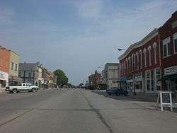 Main street in Eureka (2012) | |
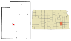 Location within Greenwood County and Kansas | |
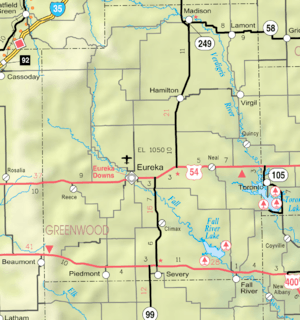 KDOT map of Greenwood County (legend) | |
| Coordinates: 37°49′22″N 96°17′22″W / 37.82278°N 96.28944°WCoordinates: 37°49′22″N 96°17′22″W / 37.82278°N 96.28944°W[1] | |
| Country | United States |
| State | Kansas |
| County | Greenwood |
| Founded | 1857 |
| Platted | 1867 |
| Incorporated | 1870 |
| Named for | Eureka |
| Area[2] | |
| • Total | 2.28 sq mi (5.91 km2) |
| • Land | 2.28 sq mi (5.91 km2) |
| • Water | 0 sq mi (0 km2) |
| Elevation[1] | 1,079 ft (329 m) |
| Population (2010)[3] | |
| • Total | 2,633 |
| • Estimate (2016)[4] | 2,410 |
| • Density | 1,200/sq mi (450/km2) |
| Time zone | UTC-6 (CST) |
| • Summer (DST) | UTC-5 (CDT) |
| ZIP code | 67045 |
| Area code | 620 |
| FIPS code | 20-21800[1][5] |
| GNIS ID | 474640[1] |
| Website |
eurekaks |
Eureka is a city and county seat of Greenwood County, Kansas, United States.[1] As of the 2010 census, the city population was 2,633,[6] the 2015 census estimate declined to 2,450.[7]
History
The first settlement at Eureka was in 1857.[8] The first post office in Eureka was established in August 1858.[9] Eureka was laid out in 1867, and it was incorporated in 1870.[8] The city is named from the Greek expression Eureka, meaning "I have found it".[10]
2016 tornado
An EF2 tornado struck Eureka on July 7, 2016 at 9:45 pm. Over 143 total structures, including at least 50 homes, businesses, a nursing home, and grain elevator were damaged. No people were injured.[11][12][13]
2018 tornado
An EF3 tornado struck Eureka on June 26, 2018 at 7:21 pm (daylight). A total of 175 structures were damaged or destroyed. 78 homes were damaged (12 not livable, 10 totaled), and 8 people were injured.[14]
Geography
Eureka is located at 37°49′22″N 96°17′22″W / 37.82278°N 96.28944°W (37.822745, −96.289583).[15] According to the United States Census Bureau, the city has a total area of 2.28 square miles (5.91 km2), all of it land.[2]
Climate
The climate in this area is characterized by hot, humid summers and generally mild to cool winters. According to the Köppen Climate Classification system, Eureka has a humid subtropical climate, abbreviated "Cfa" on climate maps.[16]
Demographics
| Historical population | |||
|---|---|---|---|
| Census | Pop. | %± | |
| 1880 | 1,127 | — | |
| 1890 | 2,259 | 100.4% | |
| 1900 | 2,091 | −7.4% | |
| 1910 | 2,333 | 11.6% | |
| 1920 | 2,606 | 11.7% | |
| 1930 | 3,698 | 41.9% | |
| 1940 | 3,803 | 2.8% | |
| 1950 | 3,958 | 4.1% | |
| 1960 | 4,055 | 2.5% | |
| 1970 | 3,576 | −11.8% | |
| 1980 | 3,425 | −4.2% | |
| 1990 | 2,974 | −13.2% | |
| 2000 | 2,914 | −2.0% | |
| 2010 | 2,633 | −9.6% | |
| Est. 2016 | 2,410 | [4] | −8.5% |
| U.S. Decennial Census | |||
2010 census
As of the census[3] of 2010, there were 2,633 people, 1,171 households, and 663 families residing in the city. The population density was 1,154.8 inhabitants per square mile (445.9/km2). There were 1,410 housing units at an average density of 618.4 per square mile (238.8/km2). The racial makeup of the city was 95.2% White, 0.2% African American, 0.9% Native American, 0.4% Asian, 1.1% from other races, and 2.2% from two or more races. Hispanic or Latino of any race were 5.3% of the population.
There were 1,171 households of which 27.2% had children under the age of 18 living with them, 41.0% were married couples living together, 10.4% had a female householder with no husband present, 5.2% had a male householder with no wife present, and 43.4% were non-families. 39.3% of all households were made up of individuals and 18.8% had someone living alone who was 65 years of age or older. The average household size was 2.17 and the average family size was 2.86.
The median age in the city was 43.2 years. 23.7% of residents were under the age of 18; 6.9% were between the ages of 18 and 24; 21.5% were from 25 to 44; 25.5% were from 45 to 64; and 22.3% were 65 years of age or older. The gender makeup of the city was 47.9% male and 52.1% female.
2000 census
As of the census[5] of 2000, there were 2,914 people, 1,278 households, and 756 families residing in the city. The population density was 1,490.1 people per square mile (574.0/km²). There were 1,561 housing units at an average density of 798.3 per square mile (307.5/km²). The racial makeup of the city was 96.26% White, 0.14% African American, 0.79% Native American, 0.14% Asian, 0.96% from other races, and 1.72% from two or more races. Hispanic or Latino of any race were 2.64% of the population.
There were 1,278 households out of which 26.1% had children under the age of 18 living with them, 46.2% were married couples living together, 8.8% had a female householder with no husband present, and 40.8% were non-families. 38.1% of all households were made up of individuals and 21.8% had someone living alone who was 65 years of age or older. The average household size was 2.18 and the average family size was 2.85.
In the city, the population was spread out with 23.2% under the age of 18, 7.8% from 18 to 24, 22.4% from 25 to 44, 19.4% from 45 to 64, and 27.3% who were 65 years of age or older. The median age was 42 years. For every 100 females, there were 85.1 males. For every 100 females age 18 and over, there were 78.8 males.
The median income for a household in the city was $26,410, and the median income for a family was $36,667. Males had a median income of $27,066 versus $20,870 for females. The per capita income for the city was $15,142. About 9.0% of families and 14.8% of the population were below the poverty line, including 18.4% of those under age 18 and 12.3% of those age 65 or over.
Transportation
Airport
Eureka Municipal Airport is a city-owned, public-use airport located two nautical miles (4 km) north of the central business district of Eureka.[17]
Area attractions
- Greenwood Hotel, a historic hotel and cattle trading center
- Former Attractions
- Eureka Downs, defunct horse racing facility
- Utopia College, former two-year college founded by Roger Babson
- Fort Montgomery, a frontier military fort
Notable people
- Jim Brothers (1941–2013) – figurative sculptor.
- Charles Errickson (1897–1985) – head football coach at Ottawa University, head football and basketball coach at Washburn University
- John Erickson (1863–1946) – 8th Governor of Montana, United States Senator, practiced law in Eureka.
- Lamon Harkness (1850–1915) – Businessman and Standard Oil heir.
- Fred Jackson (1868–1931) – U.S. Representative from Kansas.
- Kathy Patrick – author, founder of Pulpwood Queens book club.
- Tyrel Reed (1989) – basketball player who played for the University of Kansas.
- Wes Santee (1932–2010) – middle distance runner.
- Bob Whittaker (1939) – U.S. Representative from Kansas 1979 to 1991; born in Eureka.[18]
- John Woods (1911–1950) – United States Army master sergeant, executioner at Nuremberg Trials.
Gallery
- Historic Images of Eureka, Special Photo Collections at Wichita State University Library
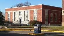 Eureka Post Office (NRHP) (2017)
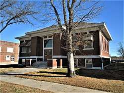 Eureka Carnegie Library (NRHP) (2017)
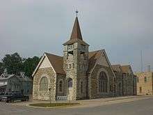 Congregational Church (2012)
 Greenwood Hotel (NRHP) (2012)
_from_NE_2.jpg) Benny's Westside Bar & Grille, formerly Westside Service Station and Riverside Motel (NRHP) (2017)
Benny's Westside Bar & Grille, formerly Westside Service Station and Riverside Motel (NRHP) (2017) Eureka Atchison, Topeka and Santa Fe Railroad Depot (NRHP) (2013)
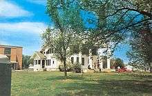 Former Utopia College (1965)
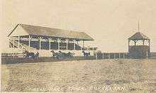 Former Eureka Downs (1910)
See also
References
- 1 2 3 4 5 Geographic Names Information System (GNIS) details for Eureka, Kansas; United States Geological Survey (USGS); October 13, 1978.
- 1 2 "US Gazetteer files 2010". United States Census Bureau. Archived from the original on January 24, 2012. Retrieved 6 July 2012.
- 1 2 "American FactFinder". United States Census Bureau. Retrieved 6 July 2012.
- 1 2 "Population and Housing Unit Estimates". Retrieved June 9, 2017.
- 1 2 "American FactFinder". United States Census Bureau. Archived from the original on September 11, 2013. Retrieved 31 January 2008.
- ↑ "2010 City Population and Housing Occupancy Status". U.S. Census Bureau. Archived from the original on July 21, 2011. Retrieved March 27, 2011.
- ↑ "Annual Estimates of the Resident Population for Incorporated Places: April 1, 2010 to July 1, 2015". Retrieved July 2, 2016.
- 1 2 Blackmar, Frank Wilson (1912). Kansas: A Cyclopedia of State History, Embracing Events, Institutions, Industries, Counties, Cities, Towns, Prominent Persons, Etc. Standard Publishing Company. p. 599.
- ↑ "Kansas Post Offices, 1828–1961 (archive)". Kansas Historical Society. Archived from the original on October 9, 2013. Retrieved June 10, 2014.
- ↑ Gannett, Henry (1905). The Origin of Certain Place Names in the United States. Govt. Print. Off. p. 122.
- ↑ Tornado mangles homes, nursing center in Eureka; The Wichita-Eagle; July 7, 2016.
- ↑ Tornado hits Eureka, homes and businesses hit, search underway; KSN tv; July 7, 2016.
- ↑ Nearly 150 structures damaged in Eureka as tornado cleanup continues; KSN tv; July 9, 2016.
- ↑ "EF-3 tornado hits Eureka, damages 78 homes and injures 8". The Wichita Eagle. June 27, 2018. Archived from the original on June 27, 2018. Retrieved June 27, 2018.
- ↑ "US Gazetteer files: 2010, 2000, and 1990". United States Census Bureau. February 12, 2011. Retrieved 23 April 2011.
- ↑ Climate Summary for Eureka, Kansas
- ↑ FAA Airport Master Record for 13K (Form 5010 PDF). Federal Aviation Administration. Effective May 31, 2012.
- ↑ "WHITTAKER, Robert Russell, (1939 – )". Biographical Directory of the United States Congress. Retrieved October 4, 2012.
Further reading
External links
| Wikimedia Commons has media related to Eureka, Kansas. |
- City
- Official city website
- Overview of Eureka government, League of Kansas Municipalities
- Greenwood County Historical Society Museum
- Eureka Lake
- Schools
- USD 389, local school district
- USD 389 School District Boundary Map, KDOT
- Maps
- Eureka City Map, KDOT
Municipalities and communities of Greenwood County, Kansas, United States | ||
|---|---|---|
| Cities | 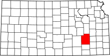 | |
| Unincorporated communities | ||
| Ghost towns | ||
| Townships | ||