Ennery, Val-d'Oise
| Ennery | ||
|---|---|---|
| Commune | ||
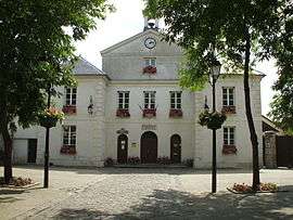 The town hall in Ennery | ||
| ||
 Ennery Location within Île-de-France region  Ennery | ||
| Coordinates: 49°04′31″N 2°06′25″E / 49.0753°N 2.1069°ECoordinates: 49°04′31″N 2°06′25″E / 49.0753°N 2.1069°E | ||
| Country | France | |
| Region | Île-de-France | |
| Department | Val-d'Oise | |
| Arrondissement | Pontoise | |
| Canton | Pontoise | |
| Intercommunality | Vallée du Sausseron | |
| Government | ||
| • Mayor (2001–2008) | Gérard Claudel | |
| Area1 | 7.43 km2 (2.87 sq mi) | |
| Population (2006)2 | 2,159 | |
| • Density | 290/km2 (750/sq mi) | |
| Time zone | UTC+1 (CET) | |
| • Summer (DST) | UTC+2 (CEST) | |
| INSEE/Postal code | 95211 /95300 | |
| Elevation | 32–104 m (105–341 ft) | |
|
1 French Land Register data, which excludes lakes, ponds, glaciers > 1 km2 (0.386 sq mi or 247 acres) and river estuaries. 2 Population without double counting: residents of multiple communes (e.g., students and military personnel) only counted once. | ||
.svg.png)
Ennery is a commune in the Val-d'Oise department in Île-de-France in northern France.
See also
References
- INSEE
- Association of Mayors of the Val d’Oise (in French)
External links
- Official website (in French)
- Mérimée database - Cultural heritage (in French)
- Land use (IAURIF) (in English)
| Wikimedia Commons has media related to Ennery (Val-d'Oise). |
This article is issued from
Wikipedia.
The text is licensed under Creative Commons - Attribution - Sharealike.
Additional terms may apply for the media files.