Emmerich am Rhein
| Emmerich | ||
|---|---|---|
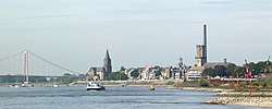 Emmerich am Rhein as seen from the east | ||
| ||
 Emmerich Location of Emmerich within Kleve district 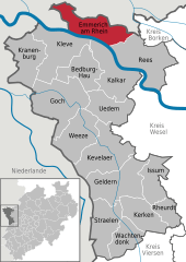  | ||
| Coordinates: 51°50′6″N 6°14′43″E / 51.83500°N 6.24528°ECoordinates: 51°50′6″N 6°14′43″E / 51.83500°N 6.24528°E | ||
| Country | Germany | |
| State | North Rhine-Westphalia | |
| Admin. region | Düsseldorf | |
| District | Kleve | |
| Founded | 700 | |
| Government | ||
| • Mayor | Peter Hinze (SPD) | |
| Area | ||
| • Total | 80.11 km2 (30.93 sq mi) | |
| Elevation | 15 m (49 ft) | |
| Population (2016-12-31)[1] | ||
| • Total | 30,852 | |
| • Density | 390/km2 (1,000/sq mi) | |
| Time zone | CET/CEST (UTC+1/+2) | |
| Postal codes | 46446 | |
| Dialling codes |
0 28 22 0 28 28 (Elten) | |
| Vehicle registration | KLE | |
| Website | www.emmerich.de | |

Emmerich am Rhein meaning Emmerich on the Rhine (Low Rhenish and Dutch: Emmerik) is a town and municipality in the northwest of the German federal state of North Rhine-Westphalia. The town has a harbour and a kay at the Rhine. In terms of local government organization, it is a medium-sized city belonging to the district of Kleve in the administrative region (Regierungsbezirk) of Düsseldorf.
Geography
Emmerich lies on the north bank of the Rhine, just within the German borders; it is only 4 km to the Netherlands to the north and 5 km to the west. Therefore it is the last German town on the Rhine before the river flows into the Netherlands.
Villages belonging to Emmerich am Rhein
The populated places which comprise the municipality of Emmerich am Rhein are Emmerich, Borghees, Dornick, Elten, Hüthum, Klein-Netterden, Leegmeer, Praest, Speelberg and Vrasselt.
Neighboring municipalities and cities
To the north, the municipality of Emmerich borders the Dutch municipalities Montferland and Oude IJsselstreek, both of which are in the Dutch province of Gelderland. To the east, it is bordered by the German city of Rees. To the south, it is bordered by the Rhine, and south of this river, by the German city of Kleve. To the west, it is bordered by the Dutch municipalities of Rijnwaarden and Zevenaar, both of which are also in the Dutch province of Gelderland.
History
Around the year 700 Saint Willibrord founded the mission "Emmerich" in the Utrecht diocese. The oldest documented name is Villa Embrici, which survives from the year 828.
_-_The_Water_Gate_in_Emmerich_am_Rhein.jpg)
The collegiate church St. Martinikirche was constructed in 1040.
On 31 May 1233 Count Otto von Zutphen and Gelder arose to the royalty of the prosperous city with the authorization of the Roman Emperor Frederick II and the German King Henry (VII) Emmerich. Emmerich became a member of the Hanseatic League at the end of the 14th century.
In 1856 the railway section Oberhausen-Arnhem, of the Cologne-Mindener Railway was opened.
Emmerich was 91% destroyed on 7 October 1944[2][3][4] as a strategic bombing target of the Oil Campaign of World War II. In 1949, Elten was annexed by the Netherlands until 1963.
Since 1 February 2001 the city has officially been called Emmerich am Rhein, until then it was simply Emmerich.[5]
On 28 November 2004 the four Catholic congregations of the city (St. Martini, St. Aldegundis, Heilig-Geist and Liebfrauen) combined to form the new city parish St. Christophorus.
Municipality and county reform
As a part of the 1st municipal restructuring program, the municipalities of Borghees, Dornick, Hüthum, Klein-Netterden, Praest and Vrasselt were integrated into the city of Emmerich on 1 July 1969. In the course of the 2nd restructuring program, the municipality of Elten was integrated as well, on 1 January 1975.
Places of interest
Holy Ghost Church This Catholic church was built in 1966 and is especially striking due to its version of the cross made of scrap metal and the Stations of the Cross made of linen. The architectural development during the time of the Second Vatican Council shaped the design of the church.

Rhine Bridge This bridge, which connects Emmerich on the north of the Rhine with Kleve on the south, was opened in 1965, and with a length of 1228 meters and a span of 500 meters it is the longest suspension bridge in Germany. Approximately 500 ships pass underneath it every day.
Rhine Museum. In the Rhine Museum, 130 ship models are exhibited, as well as a radar unit, examples of fish taxidermy, maps of the Rhine, a historic Christophorus figurine and a library of the city’s history. In addition there is a Biber submarine, a one-man U-Boat from World War II and exhibitions regarding shipping on the Rhine, the history of the city and fisheries.
PAN-Art Forum/Poster Museum. The famous poster collection is displayed in the former Lohmann chocolate factory in rotating exhibits.
Transport
Railways
Emmerich station is located about 1 km southeast of the city center on the double-track electrified “Holland Route,” which plays an important role in passenger travel and commercial transport and is therefore treated in the EU as a part of the Trans-European Network in the category “priority projects which should be begun before 2010.” In addition to the ICE International from Amsterdam to Frankfurt am Main, the night train CityNightLine to southern Germany, Austria and to Switzerland travels through here with a stop in Emmerich.
With regards to regional rail transport, the following trains pass through Emmerich, in general every hour:
- the Rhein-Express (RE5) from Emmerich to Koblenz and
- the Regional Train Der Weseler (RB35) from Emmerich to Duisburg, and at rush hour to Düsseldorf.

There is another station located on the same line near Emmerich, the stop Praest, which is only served by the Regional Train Der Weseler (RB 35).
Roads
Emmerich lies on the A3 motorway (known in German as the Bundesautobahn 3), which has the European designation E35. It also lies on the B8 (the Bundesstrasse 8) and the B220.
Inland waterways
- The Rhine
- The Municipal Rhine Harbour of Emmerich

People
- Wilhelm Normann, the inventor of fat hardening by hydrogenation.
- Albrecht Wolters (1822- 1878 in Halle, Saale), German Protestant theologian
- Anton de Waal (1837-1917 in Rome), German Catholic priest, prelate, historian and author
- Friedrich Wilhelm Franz Nippold (1838-1918 in Oberursel), German Protestant theologian
- Ernst Heinrich Göring (1839-1913 in Munich), German jurist, Reichkommissar for German South-West Africa, father of the national socialist politician Hermann Göring
- Ernst Diehl (1874-1947 in Munich), German classical philologist and epigraph
- Karl Scheele (1884-1966), German surgeon
- Eduard Künneke (1885-1953 in Berlin), German operetta composer
- Werner Müller (1907-1990 in Bad Urach), German ethnologist
- Ernst van Aaken (1910-1984 in Schwalmtal-Waldniel), German sports physician and coach
- Rainer Bonhof, (born 1952), former Dutch-German footballer for the German national team, was born in Emmerich.
- Ulrich Surau (born 1952), German footballer
- Charlie Martin (born 1972), German magician
- Alexander Müller (born 1979), German racing driver
- Nico Hülkenberg, (born 1987), Formula 1 racing driver, 2015 24 Hours of Le Mans winner and 2009 GP 2 champion
- Robin Gosens (born 1994), German footballer
Twinned towns
Emmerich am Rhein is twinned with:[6]


References
- ↑ "Amtliche Bevölkerungszahlen" (in German). Landesbetrieb Information und Technik NRW. Retrieved 2018-02-24.
- ↑ Royal Air Force Bomber Command. Campaign Diary October 1944 Archived June 11, 2007, at the Wayback Machine.
- ↑ Friedrich, Jörg: The fire. The bombing of Germany, 1940-1945. Columbia University Press, New York 2008, ISBN 978-0-231-13381-4, p. 115
- ↑ Schnatz, Helmut: Die Zerstörung der deutschen Städte und die Opfer. in: Hessische Landeszentrale für politische Bildung: Der Bombenkrieg und seine Opfer, Polis Nr. 39, Frankfurt am Main 2004 p. 44, PDF
- ↑ Stadtinformation - Daten und Fakten Stadt Emmerich
- ↑ Partnerstädte
Towns and municipalities in Kleve (district) | ||
|---|---|---|