Düsseldorf (region)
| Regierungsbezirk Düsseldorf | |
|---|---|
| Regierungsbezirk | |
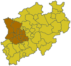 Map of North Rhine-Westphalia highlighting the Regierungsbezirk of Regierungsbezirk Düsseldorf | |
| Country | Germany |
| State | North Rhine-Westphalia |
| Region seat | Düsseldorf |
| Area | |
| • Total | 5,289.81 km2 (2,042.41 sq mi) |
| Population (31 December 2016)[1] | |
| • Total | 5,190,790 |
| • Density | 980/km2 (2,500/sq mi) |
| Website | bezreg-duesseldorf.nrw.de |
Düsseldorf is one of the five Regierungsbezirke of North Rhine-Westphalia, Germany, located in the north-west of the country. It covers the western part of the Ruhr Area, as well as the Niederrheinische Tiefebene, the lower Rhine area. It is the most populated of all German administrative areas of the kind. It is the only area in Germany where the traditional dialects are Low Franconian, rather than Low German or High German.
It was created as a subdivision of the Prussian Rhineland when Prussia reformed its internal administration in 1815. In 1822 the Regierungsbezirk Kleve was incorporated into Regierungbezirk Düsseldorf.
Its highest point is the Brodtberg (378 m).
| Kreise (districts) |
Kreisfreie Städte (district-free towns) |
|---|---|
References
- ↑ "Amtliche Bevölkerungszahlen" (in German). Landesbetrieb Information und Technik NRW. Retrieved 2018-02-24.
External links
Administrative regions (Regierungsbezirk) in North Rhine-Westphalia | |||
|---|---|---|---|
This article is issued from
Wikipedia.
The text is licensed under Creative Commons - Attribution - Sharealike.
Additional terms may apply for the media files.