Straelen
| Straelen | ||
|---|---|---|
 | ||
| ||
 Straelen Location of Straelen within Kleve district 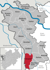  | ||
| Coordinates: 51°27′00″N 06°16′00″E / 51.45000°N 6.26667°ECoordinates: 51°27′00″N 06°16′00″E / 51.45000°N 6.26667°E | ||
| Country | Germany | |
| State | North Rhine-Westphalia | |
| Admin. region | Düsseldorf | |
| District | Kleve | |
| Government | ||
| • Mayor | Jörg Langemeyer (CDU) | |
| Area | ||
| • Total | 74 km2 (29 sq mi) | |
| Elevation | 35 m (115 ft) | |
| Population (2016-12-31)[1] | ||
| • Total | 15,901 | |
| • Density | 210/km2 (560/sq mi) | |
| Time zone | CET/CEST (UTC+1/+2) | |
| Postal codes | 47638 | |
| Dialling codes | 02834 & 02839 | |
| Vehicle registration | KLE | |
| Website | www.straelen.de | |

Straelen (German pronunciation: [ˈʃtʁaːlən]) is a municipality in the district of Cleves, in North Rhine-Westphalia, Germany. It is located near the border with the Netherlands, approx. 10 km north-east of Venlo.
History
![]()
![]()
![]()
![]()
![]()
![]()
![]()
![]()
![]()
![]()
![]()
![]()
![]()
![]()
![]()
![]()
![]()
![]()
Straelen was first mentioned in Latin as Strala in 1063.

References
- ↑ "Amtliche Bevölkerungszahlen" (in German). Landesbetrieb Information und Technik NRW. Retrieved 2018-02-24.
External links
- Official website

Towns and municipalities in Kleve (district) | ||
|---|---|---|
| Authority control |
|---|