Rheurdt
| Rheurdt | ||
|---|---|---|
| ||
 Rheurdt Location of Rheurdt within Kleve district 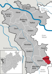  | ||
| Coordinates: 51°28′00″N 06°28′00″E / 51.46667°N 6.46667°ECoordinates: 51°28′00″N 06°28′00″E / 51.46667°N 6.46667°E | ||
| Country | Germany | |
| State | North Rhine-Westphalia | |
| Admin. region | Düsseldorf | |
| District | Kleve | |
| Government | ||
| • Mayor | Klaus Kleinenkuhnen | |
| Area | ||
| • Total | 30 km2 (10 sq mi) | |
| Elevation | 30 m (100 ft) | |
| Population (2016-12-31)[1] | ||
| • Total | 6,673 | |
| • Density | 220/km2 (580/sq mi) | |
| Time zone | CET/CEST (UTC+1/+2) | |
| Postal codes | 47509 | |
| Dialling codes | 0 28 45 / 0 28 33 | |
| Vehicle registration | KLE | |
| Website | www.rheurdt.de | |


Rheurdt, church: Pfarrkirche Sankt Nikolaus
Rheurdt (German pronunciation: [ʁøːɐ̯t]) is a municipality in the district of Cleves, in North Rhine-Westphalia, Germany. It is located approximately 10 km west of Moers.
Towns and municipalities in Kleve (district) | ||
|---|---|---|
References
- ↑ "Amtliche Bevölkerungszahlen" (in German). Landesbetrieb Information und Technik NRW. Retrieved 2018-02-24.
This article is issued from
Wikipedia.
The text is licensed under Creative Commons - Attribution - Sharealike.
Additional terms may apply for the media files.