Gemert-Bakel
| Gemert-Bakel | |||
|---|---|---|---|
| Municipality | |||
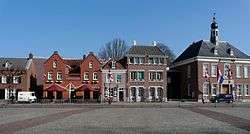 Gemert town centre | |||
| |||
.svg.png) Location in North Brabant | |||
| Coordinates: 51°33′N 5°41′E / 51.550°N 5.683°ECoordinates: 51°33′N 5°41′E / 51.550°N 5.683°E | |||
| Country | Netherlands | ||
| Province | North Brabant | ||
| Established | 1 January 1997[1] | ||
| Government[2] | |||
| • Body | Municipal council | ||
| • Mayor | Michiel van Veen (VVD) | ||
| Area[3] | |||
| • Total | 123.34 km2 (47.62 sq mi) | ||
| • Land | 122.53 km2 (47.31 sq mi) | ||
| • Water | 0.81 km2 (0.31 sq mi) | ||
| Elevation[4] | 15 m (49 ft) | ||
| Population (August 2017)[5] | |||
| • Total | 30,252 | ||
| • Density | 247/km2 (640/sq mi) | ||
| Time zone | UTC+1 (CET) | ||
| • Summer (DST) | UTC+2 (CEST) | ||
| Postcode | 5420–5425, 5760–5764 | ||
| Area code | 0492, 0493 | ||
| Website |
www | ||

Gemert-Bakel (![]()
Geography
Population centres
Topography

Dutch Topographic map of the municipality of Gemert-Bakel, June 2015
Climate
Climate in this area has mild differences between highs and lows, and there is adequate rainfall year-round. The Köppen Climate Classification subtype for this climate is "Cfb". (Marine West Coast Climate/Oceanic climate).[6]
| Climate data for Gemert-Bakel | |||||||||||||
|---|---|---|---|---|---|---|---|---|---|---|---|---|---|
| Month | Jan | Feb | Mar | Apr | May | Jun | Jul | Aug | Sep | Oct | Nov | Dec | Year |
| Average high °C (°F) | 4 (39) |
4 (39) |
9 (49) |
13 (56) |
18 (64) |
21 (69) |
22 (72) |
22 (71) |
19 (66) |
14 (57) |
8 (47) |
6 (43) |
13 (56) |
| Average low °C (°F) | −1 (31) |
−2 (29) |
2 (35) |
4 (39) |
7 (45) |
10 (50) |
13 (55) |
12 (54) |
10 (50) |
7 (44) |
3 (38) |
2 (36) |
6 (42) |
| Average precipitation mm (inches) | 69 (2.7) |
50 (2) |
79 (3.1) |
30 (1.2) |
48 (1.9) |
58 (2.3) |
89 (3.5) |
81 (3.2) |
71 (2.8) |
50 (2) |
48 (1.9) |
61 (2.4) |
734 (28.9) |
| Average precipitation days | 8.8 | 6.3 | 5.8 | 4 | 6 | 6.7 | 7.8 | 8.7 | 8.2 | 7 | 5.4 | 8.8 | 83.5 |
| Source: Weatherbase [7] | |||||||||||||
Castle
In the centre of Gemert stands a castle of which the oldest parts date back to the Late Middle Ages, although it has been rebuilt a couple of times. It was founded by German knights who lived in the castle for several hundred years, however these days it is occupied by monks and nuns. The predecessor of this castle was a motte-and-bailey located further to the west and was discovered in 1995. It is said that the townfounder Diederik van Gemert lived here.
People from Gemert
Humanist Georgius Macropedius is one of the notable people to have been born in Gemert, and a school and park have been named after him.
Trivia
The spoken language is Peellands (an East Brabantian dialect, which is very similar to colloquial Dutch).[8]
References
- ↑ "Gemeentelijke indeling op 1 januari 1997" [Municipal divisions on 1 January 1997]. cbs.nl (in Dutch). CBS. Retrieved 26 May 2014.
- ↑ "Burgemeester" [Mayor] (in Dutch). Gemeente Gemert-Bakel. Archived from the original on 28 May 2014. Retrieved 26 May 2014.
- ↑ "Kerncijfers wijken en buurten" [Key figures for neighbourhoods]. CBS Statline (in Dutch). CBS. 2 July 2013. Retrieved 12 March 2014.
- ↑ "Postcodetool for 5421CV". Actueel Hoogtebestand Nederland (in Dutch). Het Waterschapshuis. Archived from the original on 21 September 2013. Retrieved 26 May 2014.
- ↑ "Bevolkingsontwikkeling; regio per maand" [Population growth; regions per month]. CBS Statline (in Dutch). CBS. 27 October 2017. Retrieved 27 October 2017.
- ↑ Climate Summary for Gemert-Bakel
- ↑ "Weatherbase.com". Weatherbase. 2013. Retrieved on June 3, 2013.
- ↑ Jos & Cor Swanenberg: Taal in stad en land: Oost-Brabants, ISBN 9012090105
External links

- Official website
Places adjacent to Gemert-Bakel | ||||||||||
|---|---|---|---|---|---|---|---|---|---|---|
| ||||||||||
