Misti
| Misti | |
|---|---|
 | |
| Highest point | |
| Elevation | 5,822 m (19,101 ft) [1] |
| Prominence | 1,785 m (5,856 ft) |
| Listing | Ultra |
| Coordinates | 16°17′40″S 71°24′32″W / 16.29444°S 71.40889°WCoordinates: 16°17′40″S 71°24′32″W / 16.29444°S 71.40889°W [1] |
| Geography | |
 Misti Peru | |
| Location | Arequipa, Peru |
| Parent range | Andes |
| Geology | |
| Mountain type | Stratovolcano |
| Volcanic arc/belt | Central Volcanic Zone |
| Last eruption | 1985 |
Misti, also known as Putina[2] or Guagua Putina[3] is a stratovolcano of andesite, dacite and rhyolite[4] located in southern Peru near the city of Arequipa. With its seasonally snow-capped, symmetrical cone, Misti stands at 5,822 metres (19,101 ft) above sea level and lies between mount Chachani (6,075 m or 19,931 ft) and Pichu Pichu volcano (5,669 m or 18,599 ft). Its last eruption was in 1985, 198 years after its previous documented eruption.[1]
Description
Misti has three concentric craters. Active fumaroles, or volcanic gas vents, can be seen in the inner crater.[5] Near the inner crater, six Inca mummies and rare Inca artifacts were found in 1998 during a month-long excavation directed by archaeologists Johan Reinhard and Jose Antonio Chavez. These findings are currently stored at the Museo de Santuarios Andinos in Arequipa.
There are two main climbing routes on the volcano. The Pastores route starts at 3,300 metres (10,800 ft). Usually a camp is made at 4,500 metres (14,800 ft) at Nido de Aguilas. The Aguada Blanca route starts at 4,000 metres (13,100 ft) near the Aguada Blanca reservoir, and a camp is made at 4,800 metres (15,700 ft) at Monte Blanco (the camp is named after Mont Blanc, the summit of which is approximately the same elevation as the camp). Neither climbing routes presents technical difficulties, but both are considered strenuous because of the steep loose sand slopes.
Surrounding area
A long history of eruptions from Misti and its neighbour volcanoes has caused the local soil to be extremely fertile, making the surrounding area one of the most agriculturally productive in Peru.[5] Locals also make extensive use of a white volcanic rock called sillar, which is strong but easily workable.[5] The city of Arequipa has a significant number of buildings constructed with sillar, resulting in the nickname la ciudad blanca, or "the white city".[5]
Gallery
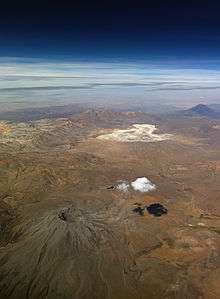 Aerial picture of Ubinas with Misti in the back
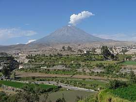
 Misti, as seen from Arequipa´s horse racecourse
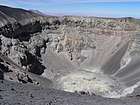 The crater
See also
References
- 1 2 3 "El Misti". Global Volcanism Program. Smithsonian Institution. Retrieved 2008-12-21.
- ↑ Thomas Besom, Of Summits and Sacrifice: An Ethnohistoric Study of Inka Religious Practices, An ethnohistoric study of Inka religious practices, University of Texas press, 2009
- ↑ "Global Volcanism Program | El Misti". volcano.si.edu. Retrieved 2017-08-16.
- ↑ http://gsabulletin.gsapubs.org/content/113/12/1593
- 1 2 3 4 Scheffel, Richard L.; Wernet, Susan J., eds. (1980). Natural Wonders of the World. United States of America: Reader's Digest Association, Inc. p. 251. ISBN 0-89577-087-3.
Further reading
- Reinhard, Johan (2005). The Ice Maiden: Inca Mummies, Mountain Gods, and Sacred Sites in the Andes. Washington, D.C.: National Geographic Society. ISBN 0-7922-6838-5.
External links
- "El Misti Volcano and Arequipa, Peru". Earth Observatory. NASA. 2009-11-02. Retrieved 2016-06-03.
- "El Misti Volcano and the City of Arequipa, Peru". Earth Observatory. NASA. 2001-12-31. Retrieved 2016-06-03.