El Malpais National Conservation Area
| El Malpais National Conservation Area | |
|---|---|
|
IUCN category V (protected landscape/seascape) | |
 El Malpais National Conservation Area | |
 Map of the United States | |
| Location | Cibola County, New Mexico, United States |
| Nearest city | Grants, New Mexico |
| Coordinates | 34°51′32″N 108°01′16″W / 34.859°N 108.021°WCoordinates: 34°51′32″N 108°01′16″W / 34.859°N 108.021°W |
| Area | 263,000 acres (1,060 km2) |
| Established | 1987 |
| Governing body | Bureau of Land Management |
| Website | El Malpais National Conservation Area |
The El Malpais National Conservation Area is a federally protected conservation area in the U.S. state of New Mexico. The El Malpais National Conservation area was established in 1987 and is managed by the Bureau of Land Management as part of the National Landscape Conservation System. The adjoining El Malpais National Monument was established at the same time and is managed by the National Park Service.
The 263,000-acre (1,060 km2) El Malpais NCA includes two wilderness areas — the West Malpais Wilderness[1] and Cebolla Wilderness Area[2] — covering almost 100,000 acres (400 km2).
Features
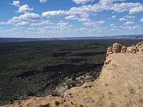
El Malpais translates to "the badlands" in Spanish and is pronounced Mal-(rhymes with wall)-pie-ees. The El Malpais National Conservation Area was established to protect nationally significant geological, archaeological, ecological, cultural, scenic, scientific, and wilderness resources surrounding the Grants Lava Flows.
In addition to the two wilderness areas, the NCA includes dramatic sandstone cliffs, canyons, La Ventana Natural Arch, the Chain of Craters Back Country Byway and the Narrows Picnic Area. There are many opportunities for photography, hiking, camping and wildlife viewing within this unique NCA.
There are two visitor centers that serve the NCA, both off of I-40. El Malpais Visitor Center, operated jointly with the National Park Service, is located on the south side of exit 85. The Bureau of Land Management Ranger Station is located about 8 miles south of exit 89 on State Highway 117.
Cultural landscape
For more than 10,000 years people have interacted with the El Malpais landscape. Historic and prehistoric Cultural landscape sites provide connections to past times. More than mere artifacts, these cultural resources are kept alive by the spiritual and physical presence of contemporary Indian groups, including the Puebloan peoples of Acoma, Laguna and Zuni, and the Ramah Navajo. These tribes continue their ancestral uses of El Malpais including gathering plant materials, paying respect, and renewing ties.
References
- ↑ "West Malpais Wilderness". Retrieved May 1, 2016.
- ↑ "Cebolla Wilderness". Retrieved May 1, 2016.
![]()
External links

- official El Malpais National Conservation Area website
- Cebolla Wilderness Area website