West Malpais Wilderness
| West Malpais Wilderness | |
|---|---|
|
IUCN category Ib (wilderness area) | |
 | |
| Location | Cibola County, New Mexico, United States |
| Nearest city | Grants |
| Coordinates | 34°53′24.6″N 108°09′30.4″W / 34.890167°N 108.158444°WCoordinates: 34°53′24.6″N 108°09′30.4″W / 34.890167°N 108.158444°W |
| Area | 35,940 acres (145.4 km2) |
| Established | 1987 |
| Governing body | United States Bureau of Land Management |
| Website | West Malpais Wilderness |
West Malpais Wilderness is a designated Wilderness Area managed by the U. S. Bureau of Land Management [BLM] located in Cibola County, New Mexico. Established in 1987, the West Malpais Wilderness is located in the El Malpais National Conservation Area, a BLM-managed area that stretches along the western border of the Acoma Indian Reservation SW of Albuquerque. One of two Wilderness Areas in the Conservation Area, the 35,940 acre West Malpais area is contiguous with El Malpais National Monument, a National Park Service unit, and contains a section of the Continental Divide National Scenic Trail.
The Conservation Area
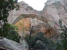
The 231,230 acre El Malpais National Conservation Area is a Bureau of Land Management area established in 2001 to protect “nationally-significant geological, archaeological, ecological, cultural, scenic, scientific, and wilderness resources surrounding the Grants Lava Flows.” The Area includes one primitive campground, several small picnic areas, two Wilderness Areas, and opportunities for hiking, horseback riding, mountain biking, and caving. Most of the lands within the Conservation Area, including the Joe Skeen primitive campground and La Ventana Natural Arch, a popular destination, can be reached via NM 117, SE of Grants. [1]
The Wilderness
Mostly flat, and with elevations averaging 7,200 feet, much of the West Malpais Wilderness consists of large areas of volcanic lava flows. This area of basalt rock is surrounded in the south by open grassland and on the west by piñon and juniper forest. The most popular area of the Wilderness is a 6,700-acre kipuka (a Hawaiian term meaning island of fertile ground) in the northern half of the wilderness known as Hole-In-The-Wall, where an island of ponderosa pine stands among the spreading waves of volcanic rock. Hiking is the most common recreational use of the area, with several trails leading to the Hole-in-the-Wall area. [2] The area has no water sources and like all Wilderness Areas, are closed to all mechanized and motorized vehicles, including mountain bicycles. Trips into the Wilderness require a backcountry permit, which can be obtained from the El Malpais Information Center in Grants, or from the BLM Ranger Station on State Road 117. [3]
Location and Access
Because West Malpais is contiguous with the El Malpais National Monument to the north, the main access to the area is along CR 42, which forms the southern and western border of the Wilderness. The trailhead for hiking into the Hole-in-the-Wall area can be reached via the eastern end of CR 42, which begins at NM 70, approximately 27 miles south of I-40. Visitors can also reach the Wilderness from the western terminus of CR 42, which begins at NM 53, 18 miles SW of I-40. A section of the Continental Divide National Scenic Trail runs through the southern half of the Wilderness Area, and can be accessed by a trailhead on CR 42, 22 miles south of N.M. 53.[3]
See also
External links
References
- ↑ "Programs: National Conservation Lands: New Mexico: El Malpais National Conservation Area | BUREAU OF LAND MANAGEMENT". Blm.gov. 2001-01-07. Retrieved 2017-06-11.
- ↑ "Wilderness.net - West Malpais Wilderness - General Information". Wilderness.net.
- 1 2 "Programs: National Conservation Lands: Wilderness: New Mexico: West Malpais Wilderness | BUREAU OF LAND MANAGEMENT". Blm.gov. Retrieved 2017-06-11.