East Stroudsburg, Pennsylvania
| Borough of East Stroudsburg US | |
|---|---|
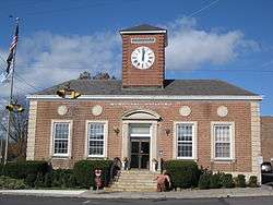 East Stroudsburg's borough hall | |
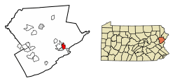 Location of East Stroudsburg in Monroe County, Pennsylvania. | |
 East Stroudsburg Location of East Stroudsburg in Pennsylvania  East Stroudsburg East Stroudsburg (the US) | |
| Coordinates: 41°00′05″N 75°10′48″W / 41.00139°N 75.18000°WCoordinates: 41°00′05″N 75°10′48″W / 41.00139°N 75.18000°W | |
| Country | United States |
| State | Pennsylvania |
| County | Monroe |
| Founded | 1738 |
| Area[1] | |
| • City | 2.86 sq mi (7.41 km2) |
| • Land | 2.84 sq mi (7.37 km2) |
| • Water | 0.02 sq mi (0.04 km2) |
| Elevation | 466 ft (142 m) |
| Population (2010) | |
| • City | 9,840 |
| • Estimate (2016)[2] | 10,189 |
| • Density | 3,582.63/sq mi (1,383.17/km2) |
| • Metro | 176,567 µSA |
| Time zone | UTC-5 (EST) |
| • Summer (DST) | UTC-4 (EDT) |
| ZIP Codes | 18301-18302 |
| Area code(s) | 570 |
| FIPS code | 42-21872 |
| Website |
www |
East Stroudsburg is a borough in Monroe County, Pennsylvania, United States. It is located in the Poconos region of the state. Originally known as "Dansbury," East Stroudsburg was renamed for geographic reasons when the Delaware, Lackawanna, and Western Railroad opened a station in town. It lies east of Stroudsburg and is more populous than that town. East Stroudsburg is the largest municipality in Monroe County and in the East Stroudsburg, PA Metropolitan Statistical Area[3] as designated by the Office of Management and Budget based on data from the 2010 US Census.
Geography
East Stroudsburg is located at 41°0′5″N 75°10′48″W / 41.00139°N 75.18000°W (41.001442, -75.180111).[4] According to the United States Census Bureau, the borough has a total area of 2.9 square miles (7.5 km2), all of it land. When traveling west on Interstate 80, East Stroudsburg is the second town from the NJ-PA border on exit 309.
Demographics
| Historical population | |||
|---|---|---|---|
| Census | Pop. | %± | |
| 1880 | 1,162 | — | |
| 1890 | 1,819 | 56.5% | |
| 1900 | 2,648 | 45.6% | |
| 1910 | 3,330 | 25.8% | |
| 1920 | 4,855 | 45.8% | |
| 1930 | 6,099 | 25.6% | |
| 1940 | 6,404 | 5.0% | |
| 1950 | 7,274 | 13.6% | |
| 1960 | 7,674 | 5.5% | |
| 1970 | 7,894 | 2.9% | |
| 1980 | 8,039 | 1.8% | |
| 1990 | 8,781 | 9.2% | |
| 2000 | 9,888 | 12.6% | |
| 2010 | 9,840 | −0.5% | |
| Est. 2016 | 10,189 | [2] | 3.5% |
| Sources:[5][6][7] | |||
As of the 2010 United States Census, there were 9,840 people residing in the borough. The racial makeup of the borough was 73.2% White, 10.0% Black, 0.1% Native American, 2.4% Asian, 0.3% from some other race and 2.0% from two or more races. 11.8% were Hispanic or Latino of any race.
History
The area of Stroudsburg was first permanently settled in 1738, when James Monroe received a warrant of 600 acres in Bucks County, now Monroe County along the east bank of the Analomink or Smithfield Creek; now named Brodhead Creek. An additional warrant for 150 acres on the west bank was given to Brodhead in 1750. Brodhead, a judge, was friendly with the local Indians, as well as with the Moravian missionaries who came to the area from Bethlehem, Pennsylvania.
The East Stroudsburg Armory and East Stroudsburg Station are listed on the National Register of Historic Places.[8]
Education
High school
Public
Private
University
Sports
Pocono Snowis an American soccer team based in East Stroudsburg, Pennsylvania, United States. Founded in 2008, the team plays in National Premier Soccer League, a national amateur league at the fourth tier of the American Soccer Pyramid, in the Eastern Keystone Division. The team plays its home games at Eiler-Martin Stadium on the campus of East Stroudsburg University, where they have played since 2009. The team's colors are orange, blue, and white.
Health system
Lehigh Valley Hospital-Pocono is a member of the Lehigh Valley Health Network-Pocono that manages five healthcare subsidiaries to collectively provide services to residents and visitors of Monroe County and surrounding counties in Pennsylvania and New Jersey. Pocono Medical Center began as General Hospital, and was founded in East Stroudsburg on Courtland Street in 1915; it became Lehigh Valley Hospital-Pocono in 2017.
Transportation
Airport
Stroudsburg-Pocono Airport is located near East Stroudsburg, in Smithfield Township, Monroe County, Pennsylvania. Stroudsburg-Pocono Airport serves East Stroudsburg and Monroe County and is owned by Robert Strenz. The paved runway extends for 3087 feet. The facility is at an elevation of 480 feet. The airport offers activities such as the Sky's the Limit Skydiving Center and a golf driving range.
Transit
The Monroe County Transit Authority, sometimes known as the Pocono Pony, serves Monroe County with five bus routes. Two of those routes, the Red and Yellow routes, serve East Stroudsburg. The Red route connects the central business district with adjacent Stroudsburg and Pocono Medical Center. The Yellow Route serves the Northern and Eastern portions of the borough, connecting them with the Stroud Mall, and the Marshall's Creek, PA area.[9]
Railway
East Stroudsburg station formerly served East Stroudsburg, but the last Erie Lackawanna Railway passenger train stopped there January, 1970. There are plans for the New Jersey Transit to run through and reopen this station.[10] Most of this project however, is currently not funded. Only the MOS (Minimum Operable Segment) of the project is being built so far, from where the Eastern end of the Lackawanna Cut-Off separates from the former Lackawanna RR main line at Port Morris Jct. to Andover, NJ. The track Eastward from East Stroudsburg to Slateford Junction is still in service and used by the Delaware-Lackawanna Railroad three times a week both to service a paper plant at Minisink Hills and interchange freight with Norfolk Southern at Slateford Jct. Heading West from East Stroudsburg the former Delaware, Lackawanna and Western (Lackawanna) double-track mainline still has a usable single track through to Scranton. The Delaware Lackawanna Railroad provides local freight service over this segment, and passenger excursions from Steamtown, USA (located in Scranton) are run several times a year to East Stroudsburg and to the Delaware Water Gap.
Pennsylvania Northeast Regional Rail Authority Project
Rail transportation plays an important part in the history of the borough and continues to have an impact today. The Pennsylvania Northeast Regional Rail Authority is a bi-county creation of both Lackawanna County and Monroe County to oversee the use of common rail freight lines in northeastern Pennsylvania, including one formerly owned by Conrail running from Scranton, through East Stroudsburg towards New Jersey, and the New York City market. There is an effort to re-establish rail passenger service via New Jersey Transit between Scranton and Hoboken, New Jersey by way of the Lackawanna Cut-Off, with connecting service into Manhattan. The first physical work of this project began in 2011.[11] Grants have been committed to bridge restoration to ensure the restoration of train movement.[12]
Media
The Pocono Record is the newspaper for Monroe County. Its coverage area centers on Stroudsburg and East Stroudsburg and includes the area's many small communities. The newspaper also covers parts of Pike, Lackawanna, Wayne and Carbon counties as well as areas of western New Jersey.
Radio
WESS at (90.3 FM) broadcasts from the Borough of East Stroudsburg as a service of East Stroudsburg University. Students and Faculty of the University provide programing often, and the station rebroadcasts BBC world service when live DJs are not available.
WSBG (93.5 FM) is a radio station broadcasting a soft adult contemporary format. Licensed to Stroudsburg, the station serves the Greater Stroudsburg area. Currently owned by iHeart Radio.
WRTI as repeated by station WRTY (91.1 FM) from Jackson Township - Temple University News, Jazz, and NPR
WXPJ at (91.9 FM) as broadcast from Hackettstown, NJ from Centenary College - independent programing and music, NPR
WHCY at (106.3 FM) is a radio station broadcasting a Contemporary Hit Radio format. It is owned by iHeart Radio.
WKRF at 107.9 FM is a radio station simulcasting a Contemporary Hit Radio format from WKRZ-FM (98.5-Freeland/Wilkes-Barre/Scranton).
Notable people
- Charlie Brenneman, professional UFC MMA fighter
- Keir Dillon, professional snowboarder, Burton Snowboards
- Bob Dorough, jazz pianist and composer of many famous Schoolhouse Rock! songs
- Francis Dunnery, musician, singer-songwriter and record producer
- Norman J. Kansfield, former President of New Brunswick Theological Seminary
- Lenny Kaye, legendary guitarist, member of Patti Smith Group
- Nellie McKay, singer-songwriter, actor, former stand-up comedian
- James Mungro, retired NFL player, Indianapolis Colts
- Nastasia Scott, 4th place, America's Next Top Model, Cycle 19
- Shelby Starner, singer-songwriter and musician
- Jimmy Terwilliger, football's 2005 Harlon Hill Trophy winner
- Phil Woods, jazz musician and compose, co-founder of famous annual Celebration of the Arts Festival
- Brian Xanders, executive with NFL's Los Angeles Rams, Denver Broncos
Historical sites
- East Stroudsburg Railroad Station (Date Listed: June 27, 1980) is an restored train station built in 1864 by the Delaware, Lackawanna and Western Railroad. The station served as the local stop for both East Stroudsburg and Stroudsburg, Pennsylvania. The depot, known locally as the Dansbury Depot for the original town name of Dansbury for Daniel Brodhead, is located at 5 S. Kistler St Street in downtown East Stroudsburg. Passenger service ended in January 1970 with the discontinuance of the Hoboken-Chicago Lake Cities, the last long-distance passenger train operated by DL&W successor Erie Lackawanna. The depot houses historical information and is used for a community center. Music on Mondays at Dansbury Depot and various festivals are held throughout the year. It was restored with community grants from the R. Dale and Frances Hughes Foundation, The East Stroudsburg Savings Foundation, and a Monroe County Hotel Tax Grant.
- East Stroudsburg Armory (Date Listed: May 9, 1991) is located on Washington Street in downtown East Stroudsburg.
- Zion Lutheran Church (Date Listed: November 9, 1972) is a historic church built in 1851 in eastern East Stroudsburg.
References
- ↑ "2016 U.S. Gazetteer Files". United States Census Bureau. Retrieved Aug 14, 2017.
- 1 2 "Population and Housing Unit Estimates". Retrieved June 9, 2017.
- ↑ Metropolitan and Micropolitan - Delineation Files - People and Households - U.S. Census Bureau Archived 2013-07-05 at the Wayback Machine.. Census.gov. Retrieved on 2013-08-09.
- ↑ "US Gazetteer files: 2010, 2000, and 1990". United States Census Bureau. 2011-02-12. Retrieved 2011-04-23.
- ↑ "Census of Population and Housing". U.S. Census Bureau. Archived from the original on 12 May 2015. Retrieved 11 December 2013.
- ↑ "American FactFinder". United States Census Bureau. Archived from the original on 2013-09-11. Retrieved 2008-01-31.
- ↑ "Incorporated Places and Minor Civil Divisions Datasets: Subcounty Resident Population Estimates: April 1, 2010 to July 1, 2012". Population Estimates. U.S. Census Bureau. Archived from the original on 17 June 2013. Retrieved 11 December 2013.
- ↑ National Park Service (2010-07-09). "National Register Information System". National Register of Historic Places. National Park Service.
- ↑ Pocono Pony Routes Archived October 5, 2011, at the Wayback Machine.
- ↑ New Jersey Transit. Njtransit.com. Retrieved on 2013-08-09.
- ↑ "New Jersey Transit". Retrieved 27 April 2016.
- ↑ Stacy M. Brown, "Pocono Record," May 17, 2016 http://www.poconorecord.com/news/20160517/grants-keep-poconos-to-new-york-commuter-train-moving
External links
| Wikimedia Commons has media related to East Stroudsburg, Pennsylvania. |

- The EastBurg Community Alliance, a 501c3 organization dedicated to revitalizing downtown East Stroudsburg, PA.
- Borough of East Stroudsburg Official Web Page.
Municipalities and communities of Monroe County, Pennsylvania, United States | ||
|---|---|---|
| Boroughs | 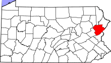 | |
| Townships | ||
| CDPs | ||
| Unincorporated communities |
| |
| Footnotes | ‡This populated place also has portions in an adjacent county | |