Mount Pocono, Pennsylvania
| Borough of Mount Pocono | |
|---|---|
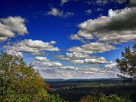 Mount Pocono Knob Lookout, looking east toward Delaware Water Gap. | |
 Location of Mount Pocono in Monroe County, Pennsylvania. | |
 Mount Pocono Location of Mount Pocono in Pennsylvania  Mount Pocono Mount Pocono (the US) | |
| Coordinates: 41°07′23″N 75°21′34″W / 41.12306°N 75.35944°WCoordinates: 41°07′23″N 75°21′34″W / 41.12306°N 75.35944°W | |
| Country | United States |
| State | Pennsylvania |
| County | Monroe |
| Government | |
| • Mayor | Frederick T. Courtright (D)[1] |
| Area[2] | |
| • Total | 3.46 sq mi (8.95 km2) |
| • Land | 3.45 sq mi (8.95 km2) |
| • Water | 0.00 sq mi (0.01 km2) |
| Elevation | 1,988 ft (606 m) |
| Population (2010) | |
| • Total | 3,170 |
| • Estimate (2016)[3] | 3,052 |
| • Density | 883.61/sq mi (341.17/km2) |
| Time zone | UTC-5 (EST) |
| • Summer (DST) | UTC-4 (EDT) |
| ZIP code | 18344 |
| Area code(s) | 570 and 272 |
| FIPS code | 42-51912 |
| Website |
mountpocono-pa |
Mount Pocono is a borough in Monroe County, Pennsylvania, in the United States. It is located nearly centered in the southernmost county of five in the northeast corner that are part of the Poconos Mountains region of the state. The borough serves as a local highway nexus, and sees a lot of tourist traffic making use of resources in the region.
As of the 2010 census, the borough population was 3,170 residents.
Geography
The town of Mount Pocono is located at 41°7′23″N 75°21′34″W / 41.12306°N 75.35944°W (41.123012, −75.359574),[4] and is nearly centered in Monroe County — the most southerly and centered county of the five counties containing portions of the Pocono Mountains of Northeastern Pennsylvania. The region's valleys includes left bank tributaries of the Lehigh River in the southern half, and as the mountain ranges narrow closer to New York, are instead drained by left bank tributaries of the Susquehanna River. To the east, all Poconos ridge lines drain into the Delaware River or right bank tributaries of the Delaware.
According to the United States Census Bureau, the borough has a total area of 3.5 square miles (9.0 km2), all of it land.
Demographics
| Historical population | |||
|---|---|---|---|
| Census | Pop. | %± | |
| 1930 | 466 | — | |
| 1940 | 648 | 39.1% | |
| 1950 | 619 | −4.5% | |
| 1960 | 935 | 51.1% | |
| 1970 | 1,019 | 9.0% | |
| 1980 | 1,237 | 21.4% | |
| 1990 | 1,795 | 45.1% | |
| 2000 | 2,742 | 52.8% | |
| 2010 | 3,170 | 15.6% | |
| Est. 2016 | 3,052 | [3] | −3.7% |
| Sources:[5][6][7] | |||
As of the census[6] of 2010, there were 3,170 people, 1,225 households, and 793 families residing in the borough. The population density was 792.2 people per square mile (306.0/km2). There were 1,417 housing units at an average density of 358.0 per square mile (138.3/km2). The racial makeup of the borough was 58.6% White, 18.6% Black or African American, 0.2% Native American, 2.2% Asian, 0.1% Pacific Islander, 0.2% from other races, and 2.4% from two or more races. Hispanic or Latino of any race were 17.7% of the population.
There were 1,225 households, out of which 32.0% had children under the age of 18 living with them, 43.8% were married couples living together, 16.0% had a female householder with no husband present, and 35.3% were non-families. 20.9% of all households were made up of individuals, and 29.6% had someone living alone who was 65 years of age or older. The average household size was 2.58 and the average family size was 3.22.
In the borough the population was spread out, with 25.5% under the age of 18, and 14.8% who were 65 years of age or older. The median age was 39.0 years.
Public education
Clear Run Elementary Center is an elementary school, grades k through 2 located in Tobyhanna, Pennsylvania. It was first opened in 1997 with the name of Pocono Mountain Elementary Center. The school changed its name to Clear Run to better reflect their local environment with Clear Run Creek behind the school. Clear Run originated with grades k through 6, but over the years it became k through 5, then ultimately split into two separate schools: Clear Run Elementary, grades k through 2 and Clear Run Intermediate, grades 3 to 6. Clear Run Intermediate was built right across the street in 2007.
The school’s mascot is a panther and their colors are blue and gray. They chose their mascot because the vast woodlands and wetlands which surround the school were once home to panthers. In the gym there is a huge panther in the middle of the floor. Clear Run also had a huge panther teddy bear that was passed around from classmate to classmate based on good behavior. Students with the panther were allowed special privileges to carry around the bear everywhere that day and to sit on the stage part of the cafeteria, with four friends.
The schools colors were chosen to resemble the colors of the common panther. The school has over 800 students that attend grades k through 2 for "Pocono Mountain School District is the largest, most diverse school district in northeast Pennsylvania".
Clear Run is an environmental school where the teachers take care of the students’ lives. On an everyday basis students and teachers create bonds where help is never far. The school is also very multi-cultural. As the schools says "All of the backgrounds and experiences that the students bring to our school make us a "melting pot." Clear Run for many years has had successful outcomes and statistics show that students that first enroll in Pocono Mountain Distinct usually graduate from it.
Transportation
Railroad
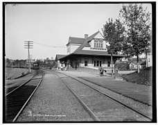
The main line of the Delaware, Lackawanna & Western Railroad passed through the southern end of the borough, providing access from New York City via the terminal at Hoboken, New Jersey. A passenger station was built at the crossing of Pennsylvania Route 611 in 1886. Most of the station was demolished in 1937 when the highway was widened. Regular passenger service to the borough ended in 1965.[8] The D., L. & W. tracks now carry freight trains of the Delaware-Lackawanna Railroad and an occasional excursion train from Steamtown National Historic Site.[9]
Bus
The Monroe County Transit Authority (MCTA) serves Monroe County with five bus routes. The Authority's Blue Route serves Mount Pocono's Main Street (Pocono Blvd.) with northbound service to Tobyhanna and southbound service to Tannersville and the Stroud Mall. Connections to other MCTA routes are provided at the Stroud Mall.[10] Martz Trailways and Greyhound Lines provide intercity bus service to Mount Pocono at the Martz Expeess bus station, with Martz Trailways connecting Mount Pocono with the Port Authority Bus Terminal in New York City and Greyhound Lines connecting Mount Pocono with the Philadelphia Greyhound Terminal in Philadelphia and Scranton.[11][12]
Air
Pocono Mountains Municipal Airport is located two miles north of the borough.
History
Early 19th-century settlers used the area for lumbering. The "New Mount Pocono" post office was established in 1848. The town's name was changed in 1864 to "Forks", because of its five-way intersection where Pennsylvania Route 611 and Pennsylvania Route 940 cross and Pennsylvania Route 196 begins. The name was changed again in 1886 to "Mount Pocono". The Delaware, Lackawanna & Western Railroad provided transportation from New York City and Philadelphia. Mount Pocono quickly developed as a summer resort, advertising clean mountain air, spring water, luxury hotels and excellent fishing.[13] The boom times lasted into the mid-20th century. Most of the resort hotels burned or closed, and passenger service to the town ended in 1965.
Mount Airy Lodge grew into an 895-room mega-resort. In the mid- and late-20th century it was a popular honeymoon destination, famous for its heart-shaped bathtubs.[14] It closed in 2001, and was demolished. Casino gambling in Pennsylvania became legal in 2004. Mount Airy Casino Resort was built on the Mount Airy Lodge's lakeside site, and opened in 2007.[15]
Resort hotels
- Pine Hill Lodge (c. 1875, still in business).[16]
- Pocono Mountain House (1878, burned 1973), 250 guest rooms.[17]
- Princess Poconita Resort (1880). Now Whispering Hills Motel.[18]
- Pocohasset House (demolished 1938), 100 guest rooms.
- Ontwood Resort (c. 1890s, burned 1979), 150 guest rooms.
- Mount Pleasant House (burned 1968), 150 guests.[19]
- Mount Airy Lodge (1898, closed 2001, demolished).[20] At its peak in the 1960s, the hotel had 895 guest rooms.
- Montanesca Hotel (1901, burned 1911), 125 guest rooms.
- The Meadowside (burned 1926).
- Hawthorne Inn (1909, demolished).[21]
- Strickland's Mountain Inn (c. 1900, demolished 2007).[22] Began as The Elvin, sold to Strickland in 1945.
- Devonshire Pines (1912, demolished), 200 guest rooms.
- The Belmont (burned 1963).
Currently, Mount Pocono serves as the commercial center for the northern part of Monroe County. Stores from national and regional chains such as Lowe's, Walmart, Weis Markets, and others are in the Borough. Local businesses include the Casino Theatre, the Village Trader, the Pioneer Diner. Many businesses are members of the Mount Pocono Association (formerly, the Mount Pocono Business Association).[23]
 Mount Pocono Station (1886, demolished 1937), circa 1905.
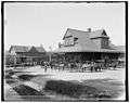
 Montanesca Hotel (1901, burned 1911).
 Pocono Summit Station, in 1988.
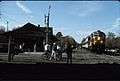 Mount Pocono Station, in 1991.
See also
References
| Wikimedia Commons has media related to Mount Pocono, Pennsylvania. |
- ↑ Pierce, David (30 August 2013). "Borough council picks mayor to fill vacancy". Pocono Record. Retrieved 21 September 2015.
Fred Courtright, the only Democrat who served on Mount Pocono Borough Council, has been appointed mayor by his GOP colleagues, filling the vacancy created by Republican Rich Dorkoski's resignation.
- ↑ "2016 U.S. Gazetteer Files". United States Census Bureau. Retrieved Aug 14, 2017.
- 1 2 "Population and Housing Unit Estimates". Retrieved June 9, 2017.
- ↑ "US Gazetteer files: 2010, 2000, and 1990". United States Census Bureau. 2011-02-12. Retrieved 2011-04-23.
- ↑ "Census of Population and Housing". U.S. Census Bureau. Retrieved 11 December 2013.
- 1 2 "American FactFinder". United States Census Bureau. Retrieved 2015-03-16.
- ↑ "Incorporated Places and Minor Civil Divisions Datasets: Subcounty Resident Population Estimates: April 1, 2010 to July 1, 2012". Population Estimates. U.S. Census Bureau. Archived from the original on 17 June 2013. Retrieved 11 December 2013.
- ↑ Mount Pocono Borough website
- ↑ Alan Sweeney, Journey along the Delaware, Lackawanna and Western Railroad (Tribute Books, 2007), p. 193.
- ↑ http://www.gomcta.com/schedules.htm
- ↑ "Daily Passenger Service Schedules" (PDF). Martz Group. Retrieved October 16, 2017.
- ↑ "Mount Pocono Pennsylvania Bus Station". Greyhound Lines. Retrieved October 17, 2017.
- ↑ "Many New Yorkers at Mount Pocono – Trout being sought", The New York Times, June 15, 1902.
- ↑ "The thrills are over at Mount Airy Lodge", The New York Times, October 31, 2001.
- ↑ Mount Airy Casino Resort
- ↑ Pine Hill Lodge from Explore PA History.
- ↑ Pocono Haven from CardCow.
- ↑ Whispering Hills Motel from Explore PA History.
- ↑ Mount Pleasant House from CardCow.
- ↑ Mount Airy Lodge from CardCow.
- ↑ Hawthorne Inn and cottages from CardCow.
- ↑ Strickland's Mountain Inn from CardCow.
- ↑ http://mtpoconoassn.com/
Municipalities and communities of Monroe County, Pennsylvania, United States | ||
|---|---|---|
| Boroughs | 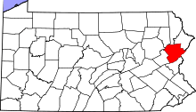 | |
| Townships | ||
| CDPs | ||
| Unincorporated communities |
| |
| Footnotes | ‡This populated place also has portions in an adjacent county | |