Sun Valley, Pennsylvania
| Sun Valley, Pennsylvania | |
|---|---|
| Census-designated place | |
 Sun Valley  Sun Valley | |
| Coordinates: 40°58′55″N 75°27′58″W / 40.98194°N 75.46611°WCoordinates: 40°58′55″N 75°27′58″W / 40.98194°N 75.46611°W | |
| Country | United States |
| State | Pennsylvania |
| County | Monroe |
| Township | Chestnuthill |
| Elevation | 1,184 ft (361 m) |
| Population (2010)[1] | |
| • Total | 2,399 |
| Time zone | UTC-5 (Eastern (EST)) |
| • Summer (DST) | UTC-4 (EDT) |
| ZIP code | 18330 |
| Area code(s) | 570 and 272 |
| GNIS feature ID | 1189060[2] |
Sun Valley is a census-designated place in NW Chestnuthill Township, Monroe County, Pennsylvania on the west side of Route 115 and the south flank of Pohopoco Mountain. The Pohopoco Creek starts in Sun Valley and flows south to Gilbert then west to Beltzville Lake and the Lehigh River. New Jersey Camp Jaycee for people with special needs is located in the CDP, which uses the Effort zip code of 18330. As of the 2010 census the population was 2,399 residents.
References
- ↑ "American FactFinder". United States Census Bureau. Retrieved 2011-05-14.
- ↑ "Sun Valley". Geographic Names Information System. United States Geological Survey.
External links
Places adjacent to Sun Valley, Pennsylvania | ||||||||||
|---|---|---|---|---|---|---|---|---|---|---|
| ||||||||||
Municipalities and communities of Monroe County, Pennsylvania, United States | ||
|---|---|---|
| Boroughs | 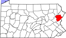 | |
| Townships | ||
| CDPs | ||
| Unincorporated communities |
| |
| Footnotes | ‡This populated place also has portions in an adjacent county | |
This article is issued from
Wikipedia.
The text is licensed under Creative Commons - Attribution - Sharealike.
Additional terms may apply for the media files.