Dushanbe
| Dushanbe Душанбе | ||
|---|---|---|
 .jpg)  _%D0%9E%D1%81%D0%BE%D1%80%D1%85%D0%BE%D0%BD%D0%B0%D0%B8_%D0%BC%D0%B8%D0%BB%D0%BB%D0%B8.jpg)  | ||
| ||
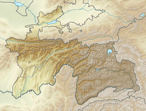 Dushanbe Location of Dushanbe in Tajikistan 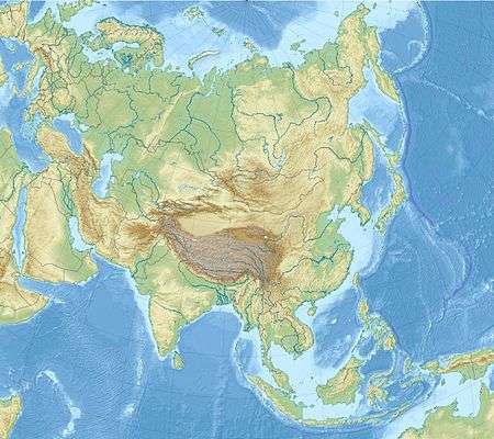 Dushanbe Dushanbe (Asia) | ||
| Coordinates: 38°32′12″N 68°46′48″E / 38.53667°N 68.78000°ECoordinates: 38°32′12″N 68°46′48″E / 38.53667°N 68.78000°E | ||
| Country |
| |
| Government | ||
| • Mayor | Rustam Emomali | |
| Area | ||
| • City | 124.6 km2 (48.1 sq mi) | |
| Elevation | 706 m (2,316 ft) | |
| Population (2014)[1] | ||
| • City | 778,500 | |
| • Density | 6,200/km2 (16,000/sq mi) | |
| • Metro | 1,051,200 | |
| Time zone | UTC+5 (Tajikistan Time) | |
| • Summer (DST) | UTC+5 (Tajikistan Time) | |
| Website |
www | |

Dushanbe (Tajik: Душанбе, IPA: [duʃænˈbe]) is the capital and largest city of Tajikistan. Dushanbe means Monday in the Tajik language.[2][3] It was named this way because it grew from a village that originally had a popular market on Mondays. As of 2016, Dushanbe had a population of 802,700.
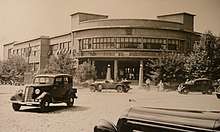
Historically a small village, Dushanbe was made the capital of the Tajik Autonomous Soviet Socialist Republic in 1924. Until 1929, the city was known in Russian as Dyushambe (Russian: Дюшамбе, Dyushambe), and from 1929 to 1961 as Stalinabad (Tajik: Сталинобод, Stalinobod) which was named after Joseph Stalin.
History
Situated at the confluence of two rivers, Varzob and Kofarnihon, Dushanbe is the capital of Tajikistan. Although archaeological remnants dating to the 5th century BC have been discovered in the area, there is little to suggest that Dushanbe was more than a small village until the early 20th century.
The first written mention of the village of Dushanbe occurred in 1676. It was at the crossroads, where a large bazaar occurred on Mondays, hence the name Dushanbe-Bazar (Tajik: Душанбе Бозор, Dushanbe Bozor)[4] from Dushanbe, which means Monday in the Persian language,[2][3] literally – the second day (du) after Saturday (shambe – ultimately from Hebrew Shabbat – שבת, probably through Byzantine Greek σάμβατον). In the village, there were more than 500 households and a population of about 8,000 people.
By 1826, the town was called Dushanbe Qurghan (Tajik: Душанбе Қурғон, Dushanbe Qurghon, with the suffix qurƣon from Turkic qurğan, meaning "fortress") Russified as Dyushambe (Дюшамбе). The first map showing Dyushambe was drafted in 1875. At that time, the town was a fortress on a steep bank on the left bank of the Varzob River with 10,000 residents.
In 1920, the last Emir of Bukhara briefly took refuge in Dyushambe after being overthrown by the Bolshevik revolution. He fled to Afghanistan after the Red Army conquered the area the next year.[5] At the beginning of 1922, the town was taken by Basmachi troops led Enver Pasha, but on 14 July 1922 again came under the power of the Bolsheviks and was proclaimed the capital of the Tajik Autonomous Soviet Socialist Republic as a part of the Uzbek Soviet Socialist Republic in 1924.
A Tajik Soviet Socialist Republic separate from the Uzbek SSR was created in 1929, and its capital Dyushambe was renamed Stalinabad (Russian: Сталинабад; Tajik: Сталинобод Stalinobod) for Joseph Stalin on 16 October 1929. In the years that followed, the city developed at a rapid pace.[6]
The Soviets transformed the area into a centre for cotton and silk production, and tens of thousands of people relocated to the city. The population also increased with thousands of Tajiks migrating to Tajikistan following the transfer of Bukhara and Samarkand to the Uzbek SSR as part of national delimitation in Central Asia.[7]
On 10 November 1961, Stalinabad was renamed Dushanbe, the name it retains to this day.
Severe rioting occurred in February 1990, after it was rumored that the Soviet government planned to relocate tens of thousands of Armenian refugees to Tajikistan. The Dushanbe riots were primarily fueled by concerns about housing shortages for the Tajik population, but they coincided with a wave of nationalist unrest that swept Transcaucasia and other Central Asian states during the twilight of Mikhail Gorbachev's rule.[8]
In January 2017, Rustam Emomali, current President Emomali Rahmon's son, was appointed Mayor of Dushanbe, a move which is seen by some analysts as a step to reaching the top of the government.[9]
Geography
Climate
Dushanbe features a Mediterranean climate (Köppen: Csa),[10] with strong continental climate influences (Köppen: Dsa).[10] The summers are hot and dry and the winters are chilly, but not very cold. The climate is damper than other Central Asian capitals, with an average annual rainfall over 500 millimetres (20 in) as moist air is funnelled by the surrounding valley during the winter and spring. Winters are not as cold as further north owing to the shielding of the city by mountains from extremely cold air from Siberia. January 2008 was particularly cold, and the temperature dropped to −22 °C (−8 °F).[11]
| Climate data for Dushanbe (1961–1990, extremes 1951–2012) | |||||||||||||
|---|---|---|---|---|---|---|---|---|---|---|---|---|---|
| Month | Jan | Feb | Mar | Apr | May | Jun | Jul | Aug | Sep | Oct | Nov | Dec | Year |
| Record high °C (°F) | 21.6 (70.9) |
23.1 (73.6) |
30.6 (87.1) |
35.6 (96.1) |
38.8 (101.8) |
43.0 (109.4) |
43.3 (109.9) |
45.0 (113) |
40.6 (105.1) |
36.8 (98.2) |
31.7 (89.1) |
24.3 (75.7) |
45.0 (113) |
| Average high °C (°F) | 7.9 (46.2) |
10.2 (50.4) |
15.2 (59.4) |
22.1 (71.8) |
27.0 (80.6) |
33.1 (91.6) |
35.8 (96.4) |
34.3 (93.7) |
30.7 (87.3) |
24.2 (75.6) |
17.1 (62.8) |
10.8 (51.4) |
22.4 (72.3) |
| Daily mean °C (°F) | 2.1 (35.8) |
3.8 (38.8) |
9.2 (48.6) |
15.4 (59.7) |
20.0 (68) |
25.3 (77.5) |
27.1 (80.8) |
24.9 (76.8) |
20.1 (68.2) |
14.3 (57.7) |
8.9 (48) |
4.8 (40.6) |
14.7 (58.5) |
| Average low °C (°F) | −2.0 (28.4) |
−0.2 (31.6) |
4.2 (39.6) |
9.3 (48.7) |
13.0 (55.4) |
16.5 (61.7) |
17.9 (64.2) |
15.9 (60.6) |
11.1 (52) |
6.7 (44.1) |
3.5 (38.3) |
0.8 (33.4) |
8.2 (46.8) |
| Record low °C (°F) | −26.6 (−15.9) |
−17.3 (0.9) |
−13.4 (7.9) |
−7.8 (18) |
1.2 (34.2) |
8.4 (47.1) |
10.9 (51.6) |
8.1 (46.6) |
1.9 (35.4) |
−4.4 (24.1) |
−13.5 (7.7) |
−19.5 (−3.1) |
−26.6 (−15.9) |
| Average precipitation mm (inches) | 66.3 (2.61) |
75.4 (2.969) |
107.5 (4.232) |
105.0 (4.134) |
66.0 (2.598) |
5.5 (0.217) |
3.2 (0.126) |
0.5 (0.02) |
3.1 (0.122) |
30.6 (1.205) |
44.7 (1.76) |
59.8 (2.354) |
567.6 (22.346) |
| Average precipitation days (≥ 1.0 mm) | 8.5 | 9.1 | 13.4 | 9.8 | 7.8 | 1.5 | 0.7 | 0.1 | 0.8 | 3.7 | 5.3 | 8.1 | 68.8 |
| Average relative humidity (%) | 69 | 67 | 65 | 63 | 57 | 42 | 41 | 44 | 44 | 56 | 63 | 69 | 57 |
| Mean monthly sunshine hours | 120 | 121 | 156 | 198 | 281 | 337 | 352 | 338 | 289 | 224 | 164 | 119 | 2,699 |
| Source #1: Deutscher Wetterdienst[12] | |||||||||||||
| Source #2: NOAA (sun, 1961–1990)[13] | |||||||||||||
Districts
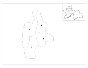
Dushanbe is divided into the following districts:
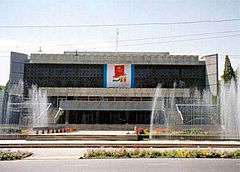
Main sights
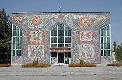
- Tajikistan National Museum (Tajik Unified Museum)
- Vahdat Palace
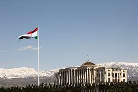
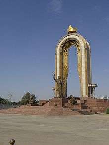
- Dushanbe Flagpole—It is the second tallest free-standing flagpole in the world, at a height of 165 metres (541 feet),[14]
- Dushanbe Zoo
- Gurminj Museum of Musical Instruments (Gurminj Museum)
Demographics
The population of Dushanbe:
- in 1987 was about 796,000 and was made up of ethnic Tajiks (75%), Uzbeks (10%), ethnic Russians (3%), and others (12%);
- in 2011 was about 679,400 and was made up of ethnic Tajiks (c. 83.4%), Uzbeks (9.1%), Russians (5.1%), and others (2.4%).
| Year | Population |
|---|---|
| 1926 | 6,000 |
| 1936 | 83,000 |
| 1956 | 227,000 |
| 1971 | 388,000 |
| 1987 | 796,000[15] |
| 1991 | 582,000 |
| 2002 | 579,000 |
| 2006 | 661,000 |
| 2008 | 679,400[16] |
| 2014 | 779,000 |
| 2015 | 788,700[17] |
| 2016 | 802,700[18] |
Economy and infrastructure
Tajik Air has its head office on the grounds of Dushanbe Airport in Dushanbe.[19] Somon Air has its head office in Dushanbe.[20]
Transport
The city is served by Dushanbe International Airport which as of April 2015, had regularly scheduled flights to major cities in Russia, Central Asia, as well as Delhi, Dubai, Frankfurt, Istanbul, Kabul, and Ürümqi amongst others. Tajikistan's principal railways are in the southern region and connect Dushanbe with the industrial areas of the Gissar and Vakhsh valleys and with Uzbekistan, Turkmenistan, Kazakhstan and Russia.[21]
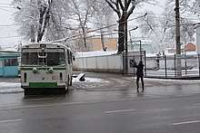
The Dushanbe trolleybus system operates public buses in the city. Automobiles are the main form of transportation in the country and as of 2014 many highway and tunnel construction projects are underway or have recently been completed. Major projects include rehabilitation of the Dushanbe – Chanak (Uzbek border), Dushanbe – Kulma (Chinese border), Kurgan-Tube – Nizhny Pyanj (Afghan border) highways and construction of tunnels under the mountain passes of Anzob, Shakhristan, Shar-Shar[22] and Chormazak.[23]
Education

A number of educational facilities are based in Dushanbe:
International relations
Twin towns – Sister cities


See also
References
- ↑ Population of the Republic of Tajikistan as of 1 January, State Statistical Committee, Dushanbe, 2012 (in Russian)
- 1 2 Dushanbe in Persian language Archived 31 January 2016 at the Wayback Machine.
- 1 2 D. Saimaddinov, S. D. Kholmatova, and S. Karimov, Tajik-Russian Dictionary, Academy of Sciences of the Republic of Tajikistan, Rudaki Institute of Language and Literature, Scientific Center for Persian-Tajik Culture, Dushanbe, 2006.
- ↑ Dushanbe in Dictionary of Geographic Names (in Russian)
- ↑ "The Last Khan". 8 March 2016. Retrieved 18 January 2018.
- 1 2 "Regions: Dushanbe & Surroundings". Official Website of the Tourism Authority of Tajikistan. Committee of Youth Affairs, Sports and Tourism. Archived from the original on 22 November 2012. Retrieved 10 May 2013.
- ↑ "Dushanbe: History". Lonely Planet. Retrieved 10 May 2013.
- ↑ Ethnic rioting in Dushanbe, New York Times, 13 February 1990. Retrieved 18 October 2008
- ↑ "Tajikistan: regime eternalization completed?". The Politicon. The Politicon. 26 January 2017. Retrieved 26 January 2017.
- 1 2 Updated Asian map of the Köppen climate classification system
- ↑ Tajikistan: Citizens Ponder Bleak Future Amid Harsh Winter | Eurasianet.Org
- ↑ "Klimatafel von Duschanbe / Tadschikistan" (PDF). Baseline climate means (1961–1990) from stations all over the world (in German). Deutscher Wetterdienst. Retrieved 18 February 2016.
- ↑ "Dushanbe Climate Normals 1961–1990". National Oceanic and Atmospheric Administration. Retrieved 18 February 2016.
- ↑ "Tallest unsupported flagpole". Guinness World Records. 24 May 2011. Retrieved 14 December 2011.
- ↑ Genesis 1987, USSR
- ↑ Population of the Republic of Tajikistan as of 1 January, State Statistical Committee, Dushanbe, 2008 (Russian)
- ↑ “TAJIKISTAN”. City Population. Retrieved 2015.01.01
- ↑ "Шумораи аҳолии Ҷумҳурии Тоҷикистон то 1 январи соли 2016 Ахбороти Агентии омори назди Президенти Ҷумҳурии Тоҷикистон" (PDF). Archived from the original (PDF) on 10 August 2017. Retrieved 22 July 2017.
- ↑ "Directory: World Airlines." Flight International. 30 March-5 April 2004. 78. "Titov Street 31/2, Dushanbe Airport, Dushanbe, 734006, Tajikistan."
- ↑ "Contacts Archived 29 January 2013 at the Wayback Machine.." Somon Air. Retrieved on 4 December 2010. "Contacts: 40, Titova Str. Dushanbe, Tajikistan, 734012." Address in Tajik : "734012, Таджикистан, Душанбе, ул. Титова, 40" "Archived copy". Archived from the original on 29 January 2013. Retrieved 2010-12-04.
- ↑ Migrant Express Part 1: Good-bye Dushanbe, https://www.youtube.com/watch?v=BBSardpSH0E
- ↑ Shar-Shar auto tunnel links Tajikistan to China, The 2.3 km (1 mi) Shar-Shar car tunnel linking Tajikistan and China opened to traffic on Aug. 30., Siyavush Mekhtan, 2009-09-03, http://centralasiaonline.com/en_GB/articles/caii/features/2009/09/03/feature-06
- ↑ Chormaghzak Tunnel renamed Khatlon Tunnel and Shar-Shar Tunnel renamed Ozodi Tunnel, 12/02/2014 15:49, Payrav Chorshanbiyev, http://news.tj/en/news/chormaghzak-tunnel-renamed-khatlon-tunnel-and-shar-shar-tunnel-renamed-ozodi-tunnel
- ↑ "Twin-cities of Azerbaijan". Azerbaijans.com. Retrieved 2013-08-09.
- ↑ "Twin towns and Sister cities of Minsk [via WaybackMachine.com]" (in Russian). The department of protocol and international relations of Minsk City Executive Committee. Archived from the original on 2 May 2013. Retrieved 2013-07-21.
External links
| Wikimedia Commons has media related to Dushanbe. |
- Pictures of Dushanbe
- Dushanbe pictures through eyes of westerner
- Tajik Web Gateway
- Boulder-Dushanbe Sister Cities
- www.dushanbeairport.com – Dushanbe International Airport unofficial website (English)
- Dushanbe – TimeLapse
