Clare, South Australia
| Clare South Australia | |||||||||||||||
|---|---|---|---|---|---|---|---|---|---|---|---|---|---|---|---|
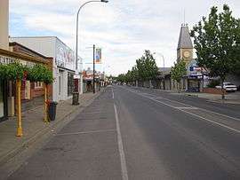 Main North Road, looking north (Note the former town hall on the right side of main street) | |||||||||||||||
 Clare | |||||||||||||||
| Coordinates | 33°50′0″S 138°36′0″E / 33.83333°S 138.60000°ECoordinates: 33°50′0″S 138°36′0″E / 33.83333°S 138.60000°E | ||||||||||||||
| Population | 3,278 (2011 census)[1] (2011 Census) | ||||||||||||||
| Established | 1842 | ||||||||||||||
| Postcode(s) | 5453 | ||||||||||||||
| Elevation | 392 m (1,286 ft) | ||||||||||||||
| Location | |||||||||||||||
| LGA(s) | District Council of Clare and Gilbert Valleys | ||||||||||||||
| Region | Yorke and Mid North [2] | ||||||||||||||
| State electorate(s) | Frome | ||||||||||||||
| Federal Division(s) | Wakefield | ||||||||||||||
| |||||||||||||||
The town of Clare (postcode 5453) is located in South Australia in the Mid North region, 136 km north of Adelaide. It gives its name to the Clare Valley wine and tourist region.
History
The first European to explore the district was John Hill, who in April 1839 discovered and named the Wakefield River and Hutt River. In early 1840 the first European settlers arrived in the district, led by John Horrocks. The town itself was established in 1842 by Edward Burton Gleeson, and named after his ancestral home of County Clare in Ireland,[3] although the town was first named Inchiquin after Gleeson's property. Lake Inchiquin is now the name of a reservoir located to the north of the town, near the golf club. The layout of the town's road system was apparently designed by a draughtsman in Adelaide, without any knowledge of the local geography. There are several roads in Clare that end abruptly at a cliff face, only to continue again at the top of the cliff.
The District Council of Clare was established in 1853 and was joined in 1868 by a corporate municipality, the Corporation of Clare. The corporate town seceded from the district council to provide dedicated local government to the township but re-amalgamated with the district council in 1969.
A railway line was built from Riverton to Clare in 1919 and on to Spalding in 1922. It closed in 1974 and the tracks were removed in the 1980s after damage caused by the Ash Wednesday fires of 1983. The alignment now carries the Riesling Trail walking and cycling trail.
In 1997 Clare and the surrounding district became a part of the much larger District Council of Clare and Gilbert Valleys for the purpose of local governance.
The town today
As one of the larger towns in the region, Clare is an administrative and service centre for the surrounding area. It has two supermarkets, many other specialty stores, two public and two private schools, three hotels, two motels, a caravan park and showground.
Clare has become recognised for its 'experiences', including the Riesling Trail walking and cycling route from 9 km north of Clare to Auburn (25 km), on the former railway alignment, so named as it weaves past vinyards and wineries, and continuing to Riverton as the Rattler Trail. The Clare Valley wine region continues within the same line of hills as the famous Barossa Valley, and also produces some excellent wine.
Governance
Clare is governed at the local level by the District Council of Clare and Gilbert Valleys. Clare lies in the state electoral district of Frome and the federal electoral division of Division of Wakefield.
Geography/climate
Clare is situated on the eponymous Clare Valley along the path of the Hutt River, about 10 km (6.2 mi) west of the Camels Hump Range and 3.5 km (2.2 mi) west of Stony Range. The Skilly Hills rise to the south-west and the Bungaree Hills rise to the north-west.
| Climate data for Clare | |||||||||||||
|---|---|---|---|---|---|---|---|---|---|---|---|---|---|
| Month | Jan | Feb | Mar | Apr | May | Jun | Jul | Aug | Sep | Oct | Nov | Dec | Year |
| Record high °C (°F) | 43.7 (110.7) |
43.6 (110.5) |
38.7 (101.7) |
36.3 (97.3) |
28.7 (83.7) |
24.2 (75.6) |
22.5 (72.5) |
26.7 (80.1) |
31.4 (88.5) |
35.6 (96.1) |
40.6 (105.1) |
41.7 (107.1) |
43.7 (110.7) |
| Average high °C (°F) | 30.3 (86.5) |
29.8 (85.6) |
26.2 (79.2) |
21.7 (71.1) |
17.2 (63) |
13.5 (56.3) |
12.8 (55) |
14.2 (57.6) |
17.3 (63.1) |
21.1 (70) |
25.1 (77.2) |
27.5 (81.5) |
21.4 (70.5) |
| Average low °C (°F) | 14.9 (58.8) |
15.0 (59) |
12.2 (54) |
9.1 (48.4) |
6.6 (43.9) |
4.9 (40.8) |
4.1 (39.4) |
4.4 (39.9) |
6.2 (43.2) |
7.9 (46.2) |
10.9 (51.6) |
12.6 (54.7) |
9.1 (48.4) |
| Record low °C (°F) | 5.0 (41) |
6.2 (43.2) |
1.4 (34.5) |
−1.0 (30.2) |
−3.7 (25.3) |
−5.0 (23) |
−3.7 (25.3) |
−3.3 (26.1) |
−2.3 (27.9) |
0.1 (32.2) |
0.1 (32.2) |
3.0 (37.4) |
−5.0 (23) |
| Average rainfall mm (inches) | 23.6 (0.929) |
25.3 (0.996) |
24.8 (0.976) |
39.5 (1.555) |
52.9 (2.083) |
66.7 (2.626) |
68.0 (2.677) |
65.9 (2.594) |
61.6 (2.425) |
44.4 (1.748) |
36.5 (1.437) |
37.9 (1.492) |
555.6 (21.874) |
| Average precipitation days | 5.0 | 4.3 | 5.4 | 7.7 | 11.6 | 14.6 | 17.3 | 16.2 | 12.5 | 8.8 | 7.6 | 6.8 | 117.8 |
| Average afternoon relative humidity (%) | 28 | 29 | 34 | 42 | 56 | 68 | 69 | 63 | 58 | 45 | 36 | 31 | 47 |
| Source: Bureau of Meteorology[4] | |||||||||||||
Notable residents
- Adey, William James[5]
- Bell, Peter Albany[6]
- Fryar, Albert
- Riley Knight
- Luke Dunstan
- Hawker, Charles Allan[7]
See also
References
- ↑ Australian Bureau of Statistics (31 October 2012). "Clare (State Suburb)". 2011 Census QuickStats. Retrieved 20 April 2014.

- ↑ "Yorke and Mid North SA Government region" (PDF). The Government of South Australia. Retrieved 10 October 2014.
- ↑ Rodney Cockburn (1984) [1908]. What's in a name? Nomenclature of South Australia. Fergusson Publications.
- ↑ "CLARE HIGH SCHOOL". Climate statistics for Australian locations. Bureau of Meteorology. June 2018. Retrieved 11 June 2018.
- ↑ Condon, Brian. Adey, William James (1874–1956). Canberra: National Centre of Biography, Australian National University.
- ↑ Tamblyn, M. Bell, Peter Albany (1871–1957). Canberra: National Centre of Biography, Australian National University.
- ↑ Dissel, Dirk Van. Hawker, Charles Allan (1894–1938). Canberra: National Centre of Biography, Australian National University.
External links
- Manning, Geoffrey. "Place Names: Clare". Manning Index of South Australian History. State Library of South Australia. Retrieved 9 August 2017.
- "Clare Regional History Group". Retrieved 9 August 2017.