District Township, Berks County, Pennsylvania
| District Township | |
|---|---|
| Township | |
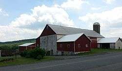 Farm in Landis Store, District Township | |
 District Township Location of District Township in Pennsylvania  District Township District Township (the US) | |
| Coordinates: 40°25′57″N 75°39′44″W / 40.43250°N 75.66222°WCoordinates: 40°25′57″N 75°39′44″W / 40.43250°N 75.66222°W | |
| Country | United States |
| State | Pennsylvania |
| County | Berks |
| Area[1] | |
| • Total | 11.61 sq mi (30.06 km2) |
| • Land | 11.58 sq mi (29.99 km2) |
| • Water | 0.03 sq mi (0.07 km2) |
| Elevation | 938 ft (286 m) |
| Population (2010) | |
| • Total | 1,337 |
| • Estimate (2016)[2] | 1,404 |
| • Density | 121.24/sq mi (46.81/km2) |
| Time zone | UTC-5 (EST) |
| • Summer (DST) | UTC-4 (EDT) |
| ZIP codes | 18011, 18062, 19504, 19512, 19539 |
| Area code(s) | 610 |
| FIPS code | 42-011-19312 |
| Website |
www |
District Township is a township in eastern Berks County, Pennsylvania, United States. The population was 1,337 at the 2010 census.
District Township was founded in 1759.[3]
Geography
According to the United States Census Bureau, the township has a total area of 11.6 square miles (30 km2), all of it land. It is drained by the Schuylkill River via the Manatawny Creek and the Perkiomen Creek via the West Branch Perkiomen Creek, which starts in the township. District Township is located in the South Mountains, and its elevations range from over 600 feet to over 1,000 feet. Its only two villages are Fredericksville and Landis Store.
Adjacent townships
- Longswamp Township (north)
- Hereford Township (east)
- Washington Township (southeast)
- Pike Township (south)
- Rockland Township (west)
Demographics
As of the census[4] of 2000, there were 1,449 people, 522 households, and 416 families residing in the township. The population density was 124.4 people per square mile (48.0/km²). There were 548 housing units at an average density of 47.0/sq mi (18.2/km²). The racial makeup of the township was 99.03% White, 0.41% African American, 0.21% Native American, 0.07% Asian, 0.14% from other races, and 0.14% from two or more races. Hispanic or Latino of any race were 0.41% of the population.
There were 522 households, out of which 36.4% had children under the age of 18 living with them, 70.9% were married couples living together, 5.6% had a female householder with no husband present, and 20.3% were non-families. 16.5% of all households were made up of individuals, and 6.9% had someone living alone who was 65 years of age or older. The average household size was 2.78 and the average family size was 3.12.
| Historical population | |||
|---|---|---|---|
| Census | Pop. | %± | |
| 1980 | 1,094 | — | |
| 1990 | 1,211 | 10.7% | |
| 2000 | 1,449 | 19.7% | |
| 2010 | 1,337 | −7.7% | |
| Est. 2016 | 1,404 | [2] | 5.0% |
| Source: US Census Bureau | |||
In the township the population was spread out, with 26.6% under the age of 18, 6.2% from 18 to 24, 29.6% from 25 to 44, 28.8% from 45 to 64, and 8.8% who were 65 years of age or older. The median age was 38 years. For every 100 females, there were 101.8 males. For every 100 females age 18 and over, there were 100.4 males.
The median income for a household in the township was $53,233, and the median income for a family was $58,158. Males had a median income of $42,404 versus $30,556 for females. The per capita income for the township was $21,663. About 4.1% of families and 3.5% of the population were below the poverty line, including 3.2% of those under age 18 and 6.7% of those age 65 or over.
Government and politics
Legislators
- State Representative Doug Reichley, Republican, 134th district
- State Senator Judy Schwank, Democrat, 11th district
- US Representative Jim Gerlach, Republican, 6th district
Board of supervisors
- Bruce B. Latshaw, chairman
- Ed Overberger, vice-chairman
- Leonard Robb
Transportation
The main roads in District Township include Bitting Road, Conrad Road, Forgedale Road/Baldy Hill Road, Huff Church Road, Landis Store Road, Long Lane, and Oysterdale Road.
References
- ↑ "2016 U.S. Gazetteer Files". United States Census Bureau. Retrieved Aug 13, 2017.
- 1 2 "Population and Housing Unit Estimates". Retrieved June 9, 2017.
- ↑ Moser, Nick (May 5, 1956). "District Township". Reading Eagle. p. 44. Retrieved 2 December 2015.
- ↑ "American FactFinder". United States Census Bureau. Archived from the original on 2013-09-11. Retrieved 2008-01-31.