Desolation Canyon
| Desolation Canyon | |
|---|---|
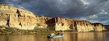
.jpg) Desolation Canyon and the Green River, August 2013 | |
| Location | Green River in Carbon, Emery, Grand, and Uintah counties in Eastern Utah, United States |
| Floor elevation | 4,318 feet (1,316 m)[1] |
| Long-axis direction | North-South |
| Geology | |
| Type | River valley |
| Geography | |
| Bounded by |
East Tavaputs Plateau (eastern) West Tavaputs Plateau (western) |
| Coordinates | 39°25′00″N 110°00′40″W / 39.41667°N 110.01111°WCoordinates: 39°25′00″N 110°00′40″W / 39.41667°N 110.01111°W |
| Population centers | None (hence the name) |
| Traversed by | None |
| Watercourses | Green River |
|
Desolation Canyon | |
 Desolation Canyon Location of Desolation Canyon within Utah  Desolation Canyon Desolation Canyon (the US) | |
| Location | Green River in Carbon, Emery, Grand, and Uintah counties in Eastern Utah, United States |
| Nearest city | East Carbon, Utah |
| Coordinates | 39°25′00″N 110°00′40″W / 39.41667°N 110.01111°W |
| NRHP reference # | 68000057 |
| Significant dates | |
| Added to NRHP | November 24, 1968[2] |
| Designated NHL | November 24, 1968[3] |
Desolation Canyon[1] is a remote canyon on the Green River in the eastern Utah, United States that is listed on the National Register of Historic Places (NRHP). It is said to be one of the most remote areas in the lower 48.[4]
Description
The canyon begins in southwestern Uintah County and then meanders roughly south to along (and becomes) the county line between Uintah and Carbon counties (including the entire eastern border of Carbon County). Continuing its southernly meanders it then becomes the county line between Emery and Grand counties, until it reaches its mouth in the Roan Cliffs. (The Green River continues flowing south through Gray Canyon.) The canyon is situated between the West Tavaputs Plateau on the west and the East Tavaputs Plateau on the east. At its deepest point, a relief of over 5,000 feet (1,500 m) exists from river level to the unseen rim of the Tavaputs Plateau.[5]
History
Over the last few thousand years, different groups of humans have occupied the area and left their traces behind. Fremont and Ute pictographs and petroglyphs are abundant in Desolation Canyon and its numerous tributary canyons, such as Nine Mile and Range Creek. Fremont granaries, as well as several abandoned homesteaders' ranches, testify to the agricultural potential of riparian alluvial fans, which are larger in Desolation Canyon than in any other canyon of the Colorado - Green river system.
The canyon was traversed by John Wesley Powell in 1869 as part of an expedition that was sponsored by the Smithsonian Institution. Originally homesteaded by the Seamount family in 1914[5], Rock Creek Ranch is still used as a horse pasture by the ranches' contemporary owners, which makes it the last property in the canyon still commercially in use. Desolation Canyon was added to the NRHP and declared a National Historic Landmark in 1968 as part of the centennial celebration of the Powell expedition.[3][6]
Recreation
During the Spring, Summer, and Fall months, many boaters each year make the 83 miles (134 km) trip through Desolation and Gray canyons from Sand Wash to Swasey's Rapid, just above the city of Green River. This section is managed by the Price office of the Bureau of Land Management, which issues permits. An additional permit must be obtained to camp or hike on the eastern side of the river, which is part of the Uintah and Ouray Indian Reservation for most of the canyon's length. As of Spring 2015, the Utes are no longer offering permits to non-tribal members. Over 60 named class two and three rapids challenge boaters, and the gradual increase in size and difficulty of rapids make it an ideal place for beginner to intermediate boaters to develop their skills. At high water (over 20,000 cubic feet per second [570 m3/s]), Joe Hutch Canyon Rapid (Cow Swim) approaches a class IV difficulty. Rapids in the canyon are big enough to swamp an open canoe at any water level.
See also
- List of canyons and gorges in Utah
- List of National Historic Landmarks in Utah
- National Register of Historic Places listings in Carbon County, Utah
- National Register of Historic Places listings in Emery County, Utah
- National Register of Historic Places listings in Grand County, Utah
- National Register of Historic Places listings in Uintah County, Utah
References
- 1 2 "Desolation Canyon". Geographic Names Information System. United States Geological Survey.
- ↑ National Park Service (2007-01-23). "National Register Information System". National Register of Historic Places. National Park Service.
- 1 2 "Desolation Canyon". National Historic Landmark summary listing. National Park Service. Retrieved 2 Apr 2008.
- ↑ Smart, Tom (25 Jan 2007). "Desolation Canyon: Horseback adventure turns into frightening journey". Deseret News. Salt Lake City: Deseret Digital Media. Retrieved 27 Jan 2018.
- 1 2 Orme, Terry (5 Aug 2004). "Rock Creek's hidden ranch". The Salt Lake Tribune. Salt Lake City: Huntsman Family Investments, LLC. Retrieved 27 Jan 2018.
- ↑ "Desolation Gray - Green River Permit, UT". recreation.gov.
External links
| Wikimedia Commons has media related to Desolation Canyon. |
- Desolation & Gray canyons river information on blm.gov
- Desolation Canyon River Access, Rapids and Points of Interest at RiverBrain
Colorado River system | |||||||||
|---|---|---|---|---|---|---|---|---|---|
| Jurisdictions |
|     | |||||||
| Canyons |
| ||||||||
| Natural features |
| ||||||||
| Tributaries | |||||||||
| Engineering |
| ||||||||
| Designated areas | |||||||||
| Related topics | |||||||||
| Topics | |
|---|---|
| Lists by states |
|
| Lists by insular areas | |
| Lists by associated states | |
| Other areas | |
| |