Deep Space Climate Observatory
|
Artist's rendering of DSCOVR | |||||||||||||
| Names | Triana | ||||||||||||
|---|---|---|---|---|---|---|---|---|---|---|---|---|---|
| Mission type | Solar observation | ||||||||||||
| Operator | NASA / NOAA | ||||||||||||
| COSPAR ID | 2015-007A | ||||||||||||
| SATCAT no. | 40390 | ||||||||||||
| Website |
www | ||||||||||||
| Mission duration |
Planned: 5 years[1] Elapsed: 3 years, 8 months, 4 days | ||||||||||||
| Spacecraft properties | |||||||||||||
| Launch mass | 570 kg (1,257 lb)[2] | ||||||||||||
| Dimensions | Undeployed: 1.4 × 1.8 m (54 × 72 in)[2] | ||||||||||||
| Power | 600 W | ||||||||||||
| Start of mission | |||||||||||||
| Launch date | February 11, 2015, 23:03:02 UTC | ||||||||||||
| Rocket | Falcon 9 v1.1 | ||||||||||||
| Launch site | Cape Canaveral SLC-40 | ||||||||||||
| Contractor | SpaceX | ||||||||||||
| Orbital parameters | |||||||||||||
| Reference system | Heliocentric | ||||||||||||
| Regime | L1 point[1] | ||||||||||||
| |||||||||||||
|
| |||||||||||||
Deep Space Climate Observatory (DSCOVR; formerly known as Triana, unofficially known as GoreSat[3]) is a NOAA space weather and Earth observation satellite. It was launched by SpaceX on a Falcon 9 launch vehicle on February 11, 2015, from Cape Canaveral.[4]
It was originally developed as a NASA satellite proposed in 1998 by then-Vice President Al Gore for the purpose of Earth observation. It is in a Lissajous orbit at the Sun–Earth L1 Lagrangian point, 1.5 million km (930 thousand mi) from Earth, to monitor variable solar wind condition, provide early warning of approaching coronal mass ejections and observe phenomena on Earth, including changes in ozone, aerosols, dust and volcanic ash, cloud height, vegetation cover and climate. At this location it has a continuous view of the Sun and of the sunlit side of the Earth. The satellite is orbiting the Sun–Earth L1 point in a six-month period, with a spacecraft–Earth–Sun angle varying from 4 to 15 degrees.[5][6] It takes full-Earth pictures about every two hours and is able to process them faster than other Earth observation satellites.[7]
DSCOVR started orbiting around L1 by June 8, 2015, just over 100 days after launch.[8] After the spacecraft arrived on site and entered its operational phase, NASA began releasing near-real time images of Earth through the EPIC instrument's website.[9]
History
Originally known as Triana, named after Rodrigo de Triana, the first of Columbus's crew to sight land in the Americas, the satellite's original purpose was to provide a near-continuous view of the entire Earth and make that live image available via the Internet. Al Gore hoped not only to advance science with these images, but also to raise awareness of the Earth itself, updating the influential Blue Marble photograph taken by Apollo 17.[10] In addition to an imaging camera, a radiometer would take the first direct measurements of how much sunlight is reflected and emitted from the whole Earth (albedo). This data could constitute a barometer for the process of global warming. The scientific goals expanded to measure the amount of solar energy reaching Earth, cloud patterns, weather systems, monitor the health of Earth's vegetation, and track the amount of UV light reaching the surface through the ozone layer.
In 1999, NASA's Inspector General reported that "the basic concept of the Triana mission was not peer reviewed", and "Triana's added science may not represent the best expenditure of NASA's limited science funding".[11] The Bush Administration put the project on hold shortly after George W. Bush's inauguration.[12] Members of the U.S. Congress asked the National Academy of Sciences whether the project was worthwhile. The resulting report, released March 2000, stated that the mission was "strong and scientifically vital".[13]
Triana was removed from its original launch opportunity on STS-107 (the ill-fated Columbia mission in 2003). The $100 million satellite remained in storage for the duration of the Bush administration. In November 2008 the satellite was removed from storage and began recertification for a possible launch on board a Delta II or a Falcon 9.[14][15] Al Gore used part of his book Our Choice (2009) as an attempt to revive debate on the DSCOVR payload. The book mentions legislative efforts by senators Barbara Mikulski and Bill Nelson to get the satellite launched.[16] NASA renamed the satellite Deep Space Climate Observatory (DSCOVR), in an attempt to regain support for the project. In February 2011, the Obama administration attempted to secure funding to re-purpose the DSCOVR spacecraft as a solar observatory to replace the aging Advanced Composition Explorer (ACE) spacecraft.[17]
In September 2013 NASA cleared DSCOVR to proceed to the implementation phase targeting an early 2015 launch,[18] which had been announced in December 2012 as launching on a SpaceX Falcon 9 rocket.[19] NASA Goddard Space Flight Center is providing management and systems engineering to the mission.
In the 2017 documentary An Inconvenient Sequel: Truth to Power, Al Gore speaks of the history of the DSCOVR satellite and its relation to climate change.[20]
Spacecraft

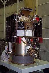
DSCOVR is built on the SMEX-Lite spacecraft bus and has a launch mass of approximately 570 kg (1,257 lb). The main science instrument sets are the Sun-observing Plasma Magnetometer (PlasMag) and the Earth-observing NIST Advanced Radiometer (NISTAR) and Earth Polychromatic Imaging Camera (EPIC). DSCOVR has two deployable solar arrays, a propulsion module, boom, and antenna.[21]
Instruments
PlasMag
The Plasma-Magnetometer (PlasMag) measures solar wind for space weather predictions. It has three instruments:[22]
- Magnetometer measures magnetic field.
- Faraday cup measures positively charged particles.
- Electrostatic analyzer measures electrons.
EPIC
The Earth Polychromatic Imaging Camera (EPIC) takes images of the sunlit side of Earth for various Earth science monitoring purposes in 10 different channels from ultraviolet to near-infrared. Ozone and aerosol levels are monitored along with cloud dynamics, properties of the land, and vegetations.[25]
EPIC has an aperture diameter of 30.5 cm (12 in), a focal ratio of 9.38, a field of view of 0.61°, and an angular sampling resolution of 1.07 arcseconds. Earth's apparent diameter varies from 0.45° to 0.53° full width. Exposure time for each of the 10 narrowband channels (317, 325, 340, 388, 443, 552, 680, 688, 764, and 779 nm) is about 40 ms. The camera produces 2048 × 2048 pixel images, but to increase the number of downloadable images to 10 per hour the resolution is averaged to 1024 × 1024 on board. The final resolution is 25 km/pixel (16 mi/pixel).[25]
NISTAR
National Institute of Standards and Technology Advanced Radiometer (NISTAR) measures irradiance of the sunlit face of the Earth. This data is to be used to study changes in Earth's radiation budget caused by natural and human activities.[26] The radiometer measures in four channels:
- For total radiation in ultraviolet, visible and infrared in the range 0.2–100 µm
- For reflected solar radiation in ultraviolet, visible and near-infrared in the range 0.2–4 µm
- For reflected solar radiation in infrared in the range 0.7–4 µm
- For calibration purposes in the range 0.3–1 µm
Launch
The launch provider SpaceX successfully launched DSCOVR on February 11, 2015, following two scrubbed launches.
Launch attempt history
| Attempt | Planned | Result | Turnaround | Reason | Decision point | Weather go (%) | Notes |
|---|---|---|---|---|---|---|---|
| 1 | 8 Feb 2015, 11:10:00 pm | Scrubbed | — | Technical | (T02:30:00) | >90 | Range issues: tracking,[27] first-stage video transmitter issues noted |
| 2 | 10 Feb 2015, 11:04:49 pm | Scrubbed | 1 day, 23 hours, 55 minutes | Weather | 80 | Upper-level winds at the launch pad exceeded 100 knots (190 km/h; 120 mph) at 25,000 feet (7,600 m) | |
| 3 | 11 Feb 2015, 11:03:32 pm | Success | 0 days, 23 hours, 59 minutes | >90 |
Post-launch flight test
SpaceX planned to conduct a test flight where they would attempt to bring the first stage back through the atmosphere and land the expended first stage on a 90-by-50-meter (300 ft × 160 ft) floating landing platform.[28][29] Relative to earlier tests, the first-stage return on DSCOVR was much more challenging, especially in atmospheric reentry due to the deep-space nature of the Earth–Sun L1 launch trajectory for DSCOVR. SpaceX expected deceleration-force loads to be twice as high and rocket heating to quadruple over the reentry conditions on Falcon 9 Flight 14.[30] Before the launch, the drone ship was in ocean surface conditions that made the barge landing infeasible. Therefore, the landing platform attempt was called off, and the first stage made an over-water soft landing instead. This continued the collection of returnable first-stage test data on all the earlier phases of the flight test and added data on stage survival following a high-speed, high-load atmospheric entry.[31]
Operation
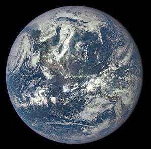
On July 6, 2015, DSCOVR returned its first publicly released view of the entire sunlit side of Earth from 1,475,207 km (916,651 mi) away, taken by the EPIC instrument. EPIC provides a daily series of Earth images, enabling the first-time study of daily variations over the entire globe. The images, available 12 to 36 hours after they are made, have been posted to a dedicated web page since September 2015.[23][24]
DSCOVR was placed in operation at the L1 Lagrangian point to monitor the Sun, because the constant stream of particles from the Sun (the solar wind) reaches L1 about 60 minutes before reaching Earth. DSCOVR will usually be able to provide a 15- to 60-minute warning before a surge of particles and magnetic field, from a coronal mass ejection (CME) reaches Earth and creates a geomagnetic storm. DSCOVR data will also be used to improve predictions of the impact locations of a geomagnetic storm to be able to take preventative action. Electronic technologies such as satellites in geosynchronous orbit are at risk of unplanned disruptions without warnings from DSCOVR and other monitoring satellites at L1.[32]
On July 16–17, 2015, DSCOVR took a series of images showing the Moon engaged in a transit of Earth. The images were taken between 19:50 and 00:45 UTC. The animation was composed of monochrome images taken in different color filters at 30-second intervals for each frame, resulting in a slight color fringing for the Moon in each finished frame. Due to its position at Sun–Earth L1, DSCOVR will always see the Moon illuminated and will always see its far side when it passes in front of Earth.[33]
On October 19, 2015, NASA opened a new website to host near-live "Blue Marble" images taken by EPIC of Earth.[9] At least twelve images are released each day at regular intervals, showcasing the Earth as it rotates on its axis.[34] The resolution of the images ranges from 10 to 15 km per pixel (6.2 to 9.4 mi/pixel), and the short exposure times renders points of starlight invisible.[34]
Animations

.gif)

See also
References
- 1 2 "NOAA Satellite and Information Service: Deep Space Climate Observatory (DSCOVR)" (PDF). NOAA. Archived from the original (PDF) on February 9, 2015. Retrieved March 14, 2015.
- 1 2 "DSCOVR: Deep Space Climate Observatory" (PDF). NOAA. January 2015. Archived from the original (PDF) on April 2, 2015. Retrieved March 14, 2015.
- ↑ Mellow, Craig (August 2014). "Al Gore's Satellite". Air & Space/Smithsonian. Retrieved December 12, 2014.
- ↑ Boyle, Alan (February 10, 2015). "SpaceX Scrubs Falcon 9's DSCOVR Launch (Again) Due to Winds". NBC News. Retrieved February 15, 2015.
- ↑ "DSCOVR Mission Hosts Two NASA Earth-Observing Instruments". NOAA. October 21, 2014. Retrieved February 9, 2015.
- ↑ Clark, Stephen (June 7, 2015). "DSCOVR space weather sentinel reaches finish line". Spaceflight Now. Retrieved June 10, 2015.
- ↑ Phillips, Ari (February 4, 2015). "A Sneak Peek at NASA's New Satellite That has Been 16 Years in the Making". ThinkProgress.
- ↑ "Nation's first operational satellite in deep space reaches final orbit". NOAA. June 8, 2015. Archived from the original on June 8, 2015. Retrieved June 8, 2015.
- 1 2 "DSCOVR: EPIC – Earth Polychromatic Imaging Camera". NASA. Retrieved October 19, 2015.
- ↑ Leary, Warren (June 1, 1999). "Politics Keeps a Satellite Earthbound". The New York Times. Retrieved July 24, 2009.
- ↑ "Assessment of the Triana Mission, G-99-013, Final Report" (PDF). Office of Inspector General. NASA. September 10, 1999. Archived from the original (PDF) on March 20, 2009. Retrieved February 7, 2009.
- ↑ Donahue, Bill (April 7, 2011). "Who killed the Deep Space Climate Observatory?". Popular Science. Retrieved December 12, 2014.
- ↑ "NASA's Triana Mission Scientific Evaluation Completed". Earth Observatory. NASA. March 8, 2000. Archived from the original on October 11, 2008. Retrieved February 3, 2008.
- ↑ Clark, Stephen (March 2, 2009). "Mothballed satellite sits in warehouse, waits for new life". Spaceflight Now. Retrieved March 2, 2009.
- ↑ "Triana/DSCOVR Spacecraft Successfully Revived from Mothballs". NASA. February 15, 2009. Archived from the original on June 12, 2009. Retrieved September 7, 2009.
- ↑ Gore, Al (2009). "Chapter 17". Our Choice. Rodale. ISBN 978-1-59486-734-7.
- ↑ Clark, Stephen (February 21, 2011). "NOAA taps DSCOVR satellite for space weather mission". Spaceflight Now. Archived from the original on February 24, 2011.
- ↑ Leslie, John (September 10, 2013). "DSCOVR Mission Moves Forward to 2015 Launch". NASA/NOAA. Retrieved September 10, 2013.
- ↑ "Spacex awarded two EELV-class missions from the United States Air Force" (Press release). SpaceX. December 5, 2012. Retrieved December 12, 2014.
- ↑ Adams, Sam (January 20, 2017). "Film review: Is Al Gore's An Inconvenient Sequel worthwhile?". BBC. Retrieved May 30, 2018.
- ↑ "Spacecraft and Instruments". NOAA. Archived from the original on February 9, 2015. Retrieved February 10, 2015.
- ↑ "NOAA Satellite and Information Service: Deep Space Climate Observatory (DSCOVR): Plasma-Magnetometer (PlasMag)" (PDF). NOAA. Archived from the original (PDF) on February 10, 2015. Retrieved February 10, 2015.
- 1 2 Northon, Karen (July 20, 2015). "NASA Captures "EPIC" Earth Image". NASA. Retrieved July 21, 2015.
- 1 2 "DSCOVR: EPIC". NASA. July 6, 2015. Retrieved February 26, 2018.
- 1 2 "NOAA Satellite and Information Service: Deep Space Climate Observatory (DSCOVR): Enhanced Polychromatic Imaging Camera (EPIC)" (PDF). NOAA. January 14, 2015. Archived from the original (PDF) on February 10, 2015. Retrieved February 10, 2015.
- ↑ "NOAA Satellite and Information Service: Deep Space Climate Observatory (DSCOVR): National Institute of Standards & Technology Advanced Radiometer (NISTAR)" (PDF). NOAA. Archived from the original (PDF) on April 22, 2015. Retrieved February 10, 2015.
- ↑ Cresswell, Miriam (February 8, 2015). "SpaceX DISCOVR launch scrubbed". Space Alabama. WAAY-TV. Archived from the original on February 11, 2015. Retrieved April 2, 2015.
- ↑ Bergin, Chris (December 17, 2014). "SpaceX confirms CRS-5 launch slip to January 6". NASA Spaceflight. Retrieved December 24, 2014.
- ↑ Graham, William (February 8, 2015). "SpaceX Falcon 9 ready for DSCOVR mission". NASA Spaceflight. Retrieved February 8, 2015.
- ↑ Musk, Elon (February 8, 2015). "Rocket reentry will be much tougher..." Twitter.com. Retrieved February 8, 2015.
- ↑ Wall, Mike (February 11, 2015). "SpaceX Won't Try Rocket Landing on Drone Ship After Satellite Launch Today". Space.com. Retrieved March 20, 2015.
- ↑ "DSCOVR: Deep Space Climate Observatory". NOAA. Retrieved July 22, 2015.
- ↑ Clark, Stephen (August 5, 2015). "Watch the moon transit the Earth". Spaceflight Now. Retrieved August 6, 2015.
- 1 2 Clark, Stephen (October 19, 2015). "NASA to post new 'blue marble' pictures every day". Spaceflight Now. Retrieved October 19, 2015.
External links
| Wikimedia Commons has media related to DSCOVR. |
- DSCOVR website at NOAA.gov
- DSCOVR at eoPortal.org
- EPIC global images at NASA.gov
Further reading
- National Research Council (March 2000). Review of Scientific Aspects of the NASA Triana Mission: Letter Report. Washington, D.C.: National Academies Press.
- Harris, Melissa (July 15, 2001). "Politics Puts $100 Million Satellite On Ice". Orlando Sentinel.
- Park, Robert L. (January 15, 2006). "Scorched Earth". The New York Times. Opinion Editorial.
- Rebuttal: Pielke Jr., Roger A. (January 15, 2006). "Re-Politicizing Triana". Center for Science and Technology Policy Research.
- Donahue, Bill (April 6, 2011). "Who Killed The Deep Space Climate Observatory?". Popular Science.
- Doody, Dave (July 28, 2015). "DSCOVR's Halo". The Planetary Society.
Falcon rocket launches | |||||||||||
|---|---|---|---|---|---|---|---|---|---|---|---|
| Falcon rocket family | |||||||||||
| Falcon 1 missions |
| ||||||||||
| Falcon 9 missions |
| ||||||||||
| Falcon Heavy missions | |||||||||||
| |||||||||||
| ||
| Politics |
|  |
| Environment | ||
| Technology | ||
| Recognition | ||
| Books | ||
| Family |
| |
| ||