The Blue Marble

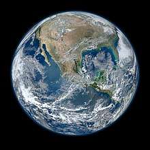
The Blue Marble is an image of planet Earth taken on December 7, 1972, by the crew of the Apollo 17 spacecraft at a distance of about 29,000 kilometers (18,000 miles) from the surface.[1][2][3] It is one of the most reproduced images in human history.[4][5]
The image with the official NASA designation AS17-148-22727[6] reproduces the view of the Earth as seen by the Apollo crew traveling toward the Moon. The translunar coast photograph extends from the Mediterranean Sea to Antarctica. This was the first time the Apollo trajectory made it possible to photograph the south polar ice cap, despite the Southern Hemisphere being heavily covered in clouds. In addition to the Arabian Peninsula and Madagascar, almost the entire coastline of Africa is clearly visible. The Asian mainland is on the horizon.
The name has also been applied by NASA to a 2012 series of image data sets covering the entire globe at relatively high resolution, created by carefully sifting through satellite-captured sequences taken over time, to eliminate as much cloud cover as possible from the collated set of images.
The photograph
The photograph, taken by astronauts on December 7, 1972, at 05:39 a.m. EST (10:39 UTC), is one of the most widely distributed photographic images in existence.[5] The image is one of the few to show an almost fully illuminated Earth as the astronauts had the Sun behind them when they took the image. To the astronauts, the slightly gibbous Earth had the appearance and size of a glass marble, hence the name. It has been mostly shown with Antarctica at the bottom, although the actual view the astronauts had was with Antarctica on top.
History

The photograph was taken about 5 hours and 6 minutes after launch of the Apollo 17 mission,[7] and about 1 hour 54 minutes after the spacecraft left its parking orbit around Earth, to begin its trajectory to the Moon.[8] The time of Apollo 17's launch, 12:33 a.m. EST, meant that Africa was in daylight during the early hours of the spacecraft's flight. With the December solstice approaching, Antarctica was also illuminated.
The 1972 Tamil Nadu cyclone can be seen in the top right of the image. This storm had brought flooding and high winds to the Indian state of Tamil Nadu on December 5, two days before the photograph was taken.[9]
The photograph's official NASA designation is AS17-148-22727. NASA photograph AS17-148-22726, taken just before and nearly identical to 22727, is also used as a full-Earth image.[7][10]
The photographer used a 70-millimeter Hasselblad camera with an 80-millimeter Zeiss lens.[11][12] NASA credits the image to the entire Apollo 17 crew—Eugene Cernan, Ronald Evans and Jack Schmitt—all of whom took photographs during the mission with the on-board Hasselblad, although evidence examined after the mission suggests that Jack Schmitt was the photographer.[5]
All Apollo flights were heavily scheduled down to the minute. At the time this photo was taken, none of the astronauts was scheduled to do so. Thus this photo was taken quickly in a stolen moment. The astronaut who took the picture was weightless, and the continents were hard to see, and he took the photo quickly, which explains why he held the camera upside down compared to the north up orientation of all maps. If every photo on this roll of film is printed, and all of the photos on the roll of film are oriented the same way, then when viewed in sequence, to put feet down and heads up, this photo will have the south pole up, breaking the map convention.[7]
Apollo 17 was the last manned lunar mission. No human since has been far enough from Earth to photograph a whole-Earth image such as The Blue Marble, but whole-Earth images have been taken by many unmanned spacecraft missions.[13]
The Blue Marble was not the first clear image taken of an illuminated face of Earth, since similar shots from the ATS-3 satellite had already been made as early as 1967.[14] The Apollo 17 image, however, released during a surge in environmental activism during the 1970s, became a symbol of the environmental movement, as a depiction of Earth's frailty, vulnerability, and isolation amid the vast expanse of space.[4] NASA archivist Mike Gentry has speculated that The Blue Marble is among the most widely distributed images in human history.[5]
Subsequent Blue Marble images
Subsequent similar images of Earth (including composites at much higher resolution) have also been termed Blue Marble images, and the phrase "blue marble" (as well as the picture itself) is frequently used, as in the Earth flag by environmental activist organizations or companies attempting to promote an environmentally conscious image. There has also been a children's television program called Big Blue Marble. Poet-diplomat Abhay K has penned an Earth Anthem inspired by the blue marble which contains "all the peoples and the nations of the world, one for all, all for one, united we unfurl the blue marble flag".[15]
Imaging series 2001–2004


In 2002, NASA released an extensive set of satellite-captured imagery, including prepared images suitable for direct human viewing, as well as complete sets suitable for use in preparing further works.[17] At the time, 1 km/pixel was the most detailed imagery available for free, and permitted for reuse[18] without a need for extensive preparatory work to eliminate cloud cover and conceal missing data, or to parse specialized data formats. The data also included a similarly manually assembled cloud-cover and night-lights image sets, at lower resolutions.
A subsequent release was made in 2005, named Blue Marble Next Generation.[19] This series of photo mosaics was produced with the aid of automated image-sifting upon images from NASA's Earth Observatory, which enabled the inclusion of a complete, cloud-free globe for each month from January to December 2004, at even higher resolution (500 m/pixel).[20] The original release of a single-image set covering the entire globe could not reflect the extent of seasonal snow-and-vegetative cover across both hemispheres, but this newer release closely modeled the changes of the seasons.
A number of interactive viewers for these data have also been released, among them a music visualization for the PS3 that is based on the texture data.[21][22]
Blue Marble 2012
On January 25, 2012, NASA released a composite image of the western hemisphere of Earth entitled Blue Marble 2012. The picture logged over 3.1 million views on the Flickr image hosting website within the first week of release.[23] On February 2, 2012, NASA released a companion to this new Blue Marble, showing a composite image of the eastern hemisphere from data obtained on January 23, 2012.[24]
The picture is composed of data obtained by the Visible/Infrared Imager Radiometer Suite (VIIRS) instrument on board the Suomi NPP satellite on January 4, 2012.[24][25] The data was obtained from six orbits of the Earth by the Suomi NPP over an eight-hour period.[24] The image was created using a near-sided perspective projection with the viewing point placed 2100 km above 20° North by 100° West. This projection results in a very wide-angle presentation such as one might get with a fish-eye lens, and it does not include the whole hemisphere.
Black Marble 2012

On December 5, 2012, NASA released a nighttime view of Earth called Black Marble[26] during an annual meeting of Earth scientists held by the American Geophysical Union in San Francisco.[27] The images display all the human and natural matter that glows and can be detected from space.[28] The data was acquired by the Suomi NPP satellite in April and October 2012 and then mapped over existing Blue Marble imagery of Earth to provide a realistic view of the planet.[29] The Suomi NPP satellite completed 312 orbits and gathered 2.5 terabytes of data to get a clear shot of every parcel of the Earth’s land surface. Named for satellite meteorology pioneer Verner Suomi, the satellite flies over any given point on Earth’s surface twice each day and flies 512 miles (824 km) above the surface in a polar orbit.[30]
The nighttime views were obtained with the new satellite's "day-night band" of the Visible Infrared Imaging Radiometer Suite (VIIRS), which detects light in a range of wavelengths from green to near-infrared, and uses filtering techniques to observe dim signals such as city lights, gas flares, auroras, wildfires, and reflected moonlight. Auroras, fires, and other stray light have been removed in the case of the Black Marble images to emphasize the city lights.[29] The images have been used to study the spatial distribution of economic activity, to select sites for astronomical observatories, and to monitor human activities around protected areas.[29]
DSCOVR
On July 21, 2015, NASA released a new Blue Marble photograph taken by a U.S. Deep Space Climate Observatory (DSCOVR), a solar weather and Earth observation satellite which was launched in February 2015 and will provide a near-continuous view of the entire sunlit-side of the Earth. The image was taken on July 6, 2015.[31] The photograph, of the Western Hemisphere, is centered over Central America. The Western United States, Mexico and the Caribbean are visible, but much of South America is hidden beneath cloud cover. Greenland can be seen at the upper edge of the image.
The EPIC science team plans to upload 13 new color images per day on their website. The color balance has been adjusted to approximate an image that could be seen with the average human eye. In addition to images, scientific information will be uploaded as it becomes available after in-flight calibration is complete. The science information will be ozone and aerosol amounts, cloud reflectivity, cloud height, and vegetation information. The EPIC instrument views the Earth from sunrise in the west to sunset in the east 12 to 13 times per day as the Earth rotates at 15 degrees of longitude per hour. Clearly visible are storms forming over the Atlantic and Pacific Oceans, major slowly moving "cloud rivers", dust aerosol plumes from Africa, the sun's reflection in the oceans, ship exhaust tracks in the clouds, rivers and lakes, and the variegated land surface patterns especially in the African deserts. The spatial resolution of the color images is about 10 km, and the resolution of the science products will be about 20 km. Once every three months, lunar images are obtained that are the same as those viewed from Earth during our full Moon. On occasion, the other side of the Moon will appear in the Earth images as the Moon crosses in front of the Earth.
See also
- Earth Anthem, an anthem by poet-diplomat Abhay K featuring the sentence "United we unfurl Blue Marble Flag".
- Earthrise, another widely reproduced picture of the Earth, which was taken in 1968, aboard Apollo 8.
- Flag of the Earth, a proposal for which features the Blue Marble photo.
- Himawari 8 and 9, geostationary satellites that produce an image of the Earth's full face every 10 minutes in the daytime
- Pale Blue Dot, an image of the Earth taken by Voyager 1.
- Stewart Brand, author who, in 1966, lobbied NASA to release a then-rumored satellite photograph of the entire Earth.
- The Day the Earth Smiled
- Whole Earth Catalog, an eclectic catalog compiled by Brand which was inspired in part by photographs of the Earth as a globe.
References
- ↑ "Apollo 17 PAO Mission Commentary Transcript" (PDF). NASA. 2001. p. 106. Retrieved May 11, 2017.
SC: You're loud and clear, Bob, and could you give us our distance from the Earth? ... CAPCOM: 18 100, Fido says.
- ↑ "Visible Earth:The Blue Marble from Apollo 17". Nasa.gov. NASA. Retrieved 10 December 2017.
- ↑ "Apollo 17 30th Anniversary: Antarctica Zoom-out". Scientific Visualization Studio. NASA. November 21, 2002. Retrieved May 11, 2017.
- 1 2 Petsko, Gregory A (2011). "The blue marble". Genome Biology. 12 (4): 112. doi:10.1186/gb-2011-12-4-112.
- 1 2 3 4 "Apollo 17: The Blue Marble". ehartwell.com. April 25, 2007. Archived from the original on January 9, 2008. Retrieved January 18, 2008.
- ↑ "Apollo Imagery". NASA. November 1, 2012. Retrieved January 6, 2018.
- 1 2 3 4 Reinert, Al (12 April 2011). "The Blue Marble Shot: Our First Complete Photograph of Earth". The Atlantic. Retrieved 1 August 2018.
- ↑ "Apollo 17 Image Library". Apollo 17 Multimedia. NASA. Retrieved April 29, 2007.
- ↑ "History of Past Cyclones". Indian Meteorological Department. Archived from the original on September 25, 2014. Retrieved September 16, 2011.
- ↑ "Worth a thousand worlds". Geek Trivia. TechRepublic. December 6, 2005. Archived from the original on April 13, 2008. Retrieved June 23, 2007.
- ↑ https://history.nasa.gov/alsj/a11/a11-hass.html
- ↑ NASA Mapping Sciences Branch (May 1974). Apollo 17 Index: 70 mm, 35 mm, and 16 mm Photographs. pp. 88. PDF.
- ↑ "Apollo 17 (AS-512) The Last Manned Lunar Landing". National Air and Space Museum - Smithsonian Institution. Retrieved Jan 30, 2018.
- ↑ "ATS-III Image Collection – Images of the Earth taken from November 1967 till March 1969". Schwerdtfeger Library – ATS-III. Retrieved July 1, 2015.
- ↑ An Anthem for the Earth The Kathmandu Post, May 25, 2013
- ↑ Also see interactive SVG map from January to December 2004 on wiki commons
- ↑ "Blue Marble : Feature Articles". Earthobservatory.nasa.gov. October 13, 2005. Retrieved December 7, 2009.
- ↑ Christoph Hormann (May 30, 2007). "Christoph's page — Earth — early renders". Imagico.de. Retrieved December 7, 2009.
- ↑ Blue Marble Next Generation Project
- ↑ Blue Marble Next Generation at NASA's Earth Observatory
- ↑ Gamasutra – Special: Q-Games On PS3's 'Gaia' Music Visualizer
- ↑ Blue Marble Next Generation : Feature Articles on Earthobservatory.nasa.gov
- ↑ Kuring, Norman. "Most Amazing High Definition Image of Earth — Blue Marble 2012". NASA. Retrieved February 12, 2012.
- 1 2 3 NASA. "VIIRS Eastern Hemisphere Image — Behind the Scenes". NASA. Retrieved February 12, 2012.
- ↑ Kuring, Normar. "Blue Marble". NASA. Retrieved February 12, 2012.
- 1 2 "NASA-NOAA Satellite Reveals New Views of Earth at Night". NASA. Retrieved December 9, 2012.
- ↑ "NASA Photos Show 'Black Marble' Earth at Night". ABC News. December 5, 2012. Retrieved December 9, 2012.
- ↑ Samenow, Jason (December 5, 2012). "Satellites unveil Black Marble and spy on the moon". The Washington Post. Retrieved December 9, 2012.
- 1 2 3 "Black Marble – Americas". NASA. Flickr. Retrieved December 9, 2012.
- ↑ "'Black Marble' images shine light upon a sleeping world". The Washington Post. December 5, 2012. Retrieved December 9, 2012.
- ↑ Lendino, Jamie. "Humanity gets a new Blue Marble photo of Earth — and it's stunning". Extreme Tech. Retrieved July 23, 2015.
External links
| Wikimedia Commons has media related to The Blue Marble. |
- NASA history of Blue Marble image releases
1972 photograph
- A short list of places in which the image has been used.
- Apollo Image Atlas Photos from magazine NN of the 70 mm Hasselblad camera used on Apollo 17 (includes the Blue Marble photo and similar photographs)
- Apollo 17 in Real-time - Blue Marble photo taken The exact moment the Blue Marble photo was taken in the context of the rest of the Apollo 17 mission.
21st century NASA composite images
- Blue Marble (2002)
- Blue Marble Mapserver Web interface for viewing small sections of the above
- Blue Marble: Next Generation (2005; one picture per month)
- Blue Marble Navigator Web interface for viewing local sections of the above, incl. links to other such interfaces, download sites etc.
- Blue Marble: Next Generation in NASA World Wind
- Wired: New Satellite Takes Spectacular High-Res Image of Earth with link to 2012 Composite in Super High Resolution.
- "Earth at Night 2012: It’s the end of the night as you know it; you’ll see fine." from Michael Carlowicz at December 5, 2012 NASA Earth Observatory site with various links around the 2012 Black Marble images
| Policy and history |
| |||||
|---|---|---|---|---|---|---|
| Robotic programs |
| |||||
| Human spaceflight programs |
| |||||
| Individual featured missions (human and robotic) | ||||||
| Communications and navigation | ||||||
| NASA lists | ||||||
| NASA images and artwork | ||||||
| ||||||