Darreh Shahr County
| Darreh Shahr County شهرستان درهشهر | |
|---|---|
| County | |
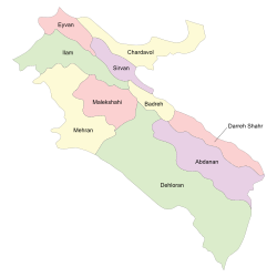 Counties of Ilam Province | |
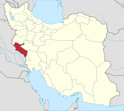 Location of Ilam Province in Iran | |
| Coordinates: 33°08′N 47°22′E / 33.133°N 47.367°ECoordinates: 33°08′N 47°22′E / 33.133°N 47.367°E | |
| Country |
|
| Province | Ilam Province |
| Capital | Darreh Shahr |
| Bakhsh (Districts) | Central District, Badreh District, Majin District |
| Population (2006) | |
| • Total | 56,346 |
| Time zone | UTC+3:30 (IRST) |
| • Summer (DST) | UTC+4:30 (IRDT) |
| Website | City's Gubernatorial Portal |
| Darreh Shahr County can be found at GEOnet Names Server, at this link, by opening the Advanced Search box, entering "9205932" in the "Unique Feature Id" form, and clicking on "Search Database". | |
Darreh Shahr County (Persian: شهرستان درهشهر) is a county in Ilam Province in Iran. The capital of the county is Darreh Shahr. At the 2006 census, the county's population was 56,346, in 11,487 families.[1] The county is subdivided into two districts: the Central District and Majin District. The seat of the county is Darreh Shahr.
Language situation
People speak Laki and Luri mostly but all of the residents of Badreh speak Kurdish.
Historical places in Darreh Shahr county
The remains of the Darreh Shahr Ancient City is situated between new city of Darreh Shahr and the Bahman Abad village. Presently, some vestiges of arches, ceilings, dome-shaped ceilings as well as indications of passages, alleys and urban connection network are visible in the texture of the ruins.[2]
Darreh Shahr Fire Temple is a four-arched building which is locally called Taaq. Originally the building was constructed by rubble stone and gypsum, and has recently been repaired.[3]
Gavmishan Bridge is located in the south of Darreh Shahr, in the beginning of a gorge with the same name on the outskirts of Kabir Kuh, is an ancient bridge with three arches that has been recently repaired (as of 2008). Each of its arches is placed at 5.5 m (18 ft) intervals from each other.[4] This Sassanide bridge has been constructed in the confluence of the Seymareh and Kashkan rivers. Although it has been repaired several times during the past, it is almost in a ruined state now.[5]
Sheikh Makan Fort is located 6 kilometers southeast of Darreh Shahr, the ruins of this fort can be seen in the entrance of the village with the same name with 150 years of antiquity. Construction materials indicate that it belongs to the Qajar period. The walls of the fort are delicately made of stone and gypsum. There is also the remains of a watermill.[6]
There are many crevices and caves. One of them is known as the Kulkani Cave. The entrance of the cave is 30 meters long and there is a small pond built of stone and Sarouj (plaster of lime and ash or sand). In addition, there are 12 other caves similar to the dwellings of pre-historic men. Some vestiges like earthenware pieces and other objects belonging to the mid 1st millennium BC have been discovered in this cave.[6]
Jaber Mausoleum which resembles the Tomb of Daniel in Susa with a northern entrance is 15 m long and 9 m wide with 8 pillars. There is an adytum in its southern wall which is 180 cm high. At the lower part there is an inscription with plaster work and adorned with floral design and sacred verses. This mausoleum is one of the important places of pilgrimage in Darreh Shahr.[7]
Baba Seifedin Mausoleum in located in the north east of Darreh Shahr in the outskirts of a hill known as Chahar Taq. There are two tombs in the mausoleum without any description on the tombstones. There is a small inscription on the top of the entrance door which indicates the date of its repair. The materials of the building are stone, gypsum and brick. There are several trees around the mausoleum which are hundreds of years old.
Tikhan (Tiqan) is located among the agricultural lands in Jamshid Abad village north east of Darreh Shahr. In excavations carried out in its location, 4 levels have been appeared. The earthenware objects obtained in the first floor are simple. Moreover, some flint blades and carved stones have been discovered there as well.[8]
Koozeh Garan Hill is about 5.5 kilometers from Tikhan Hill, and is larger and older than it. Its antiquity dates back to the late 3rd millennium BC., but its first floor relates to the Sassanide period. Some colored and engraved earthenware objects have been discovered in the basement of the building. Certain parts of lower floors had been allocated as a graveyard. The upper graves belong to the Zoroastrian period. It is said that this place was a pottery making vicinity so to speak.[9]
Cham Namesht Bridge is a 18-arch bridge constructed on the Seymareh river 4 kilometers north of Darreh Shahr facing the Chamkalan village. The antiquity of this bridge dates back to the Sassanide period, but it was used till later centuries. The bridge is directly connected to the remains of the Sassanide monuments in Darreh Shahr.[10]
Bahram-e Chobineh Gorge, a narrow and high valley, is one of the most important and strategic points of the region, located in the western side of the Darreh Shahr - Pol Dokhtar road. This gorge, which is also called the Bahram Hunting Ground, contains several historical monuments in its entrance and on the hard rocks like the ruins of a Sassanide castle which is built of stone and gypsum with stone stairs and four connected water reservoirs (Ab Anbar) which are worth seeing.[11]
Imamzadeh Saleh is located in Majeen Graveyard near Darreh Shahr. This quadrangular and two-story building has a pyramid shaped dome. The main tomb is located in the first floor which is totally made up of brick with a herringbone arch. In the second floor, there is a tomb covered with stone, gypsum and earthenware. Its antiquity dates back to the 8th century AH. and needs some repair. Interior plaster works of the Imamzadeh are unique and counted as worthy vestiges of this period.[12]
Flora and fauna
Numerous plant and animal species are found around Darreh Shahr. About 1,000 plant species exist in mountainous regions around the city. Approximately 30% of these species has pharmaceutical and nutritious value.[13] Along the Zagros range, the forest is more impoverished.[14]
References
- ↑ "Census of the Islamic Republic of Iran, 1385 (2006)". Islamic Republic of Iran. Archived from the original (Excel) on 2011-11-11.
- ↑ "Dareh Shahr Ancient City in Dareh Shahr , [Iran Tourism & Touring Organization]". www.itto.org. Retrieved 2017-07-26.
- ↑ "Dareh Shahr Fire Temple in Dareh Shahr , [Iran Tourism & Touring Organization]". www.itto.org. Retrieved 2017-07-26.
- ↑ "Dareh Shahr, the summer capital of Elamites". tehrantimes.com. Tehran, Iran: Tehran Times. 20 April 2013. Retrieved 13 June 2014.
- ↑ "Gavmishan Bridge in Dareh Shahr , [Iran Tourism & Touring Organization]". www.itto.org. Retrieved 2017-07-26.
- 1 2 "Sheikh Makan Fort in Dareh Shahr , [Iran Tourism & Touring Organization]". www.itto.org. Retrieved 2017-07-26.
- ↑ "Jaber Mausoleum in Dareh Shahr , [Iran Tourism & Touring Organization]". www.itto.org. Retrieved 2017-07-26.
- ↑ "Tikhan (Tiqan) Hill in Dareh Shahr , [Iran Tourism & Touring Organization]". www.itto.org. Retrieved 2017-07-26.
- ↑ "Koozeh Garan Hill in Dareh Shahr , [Iran Tourism & Touring Organization]". www.itto.org. Retrieved 2017-07-26.
- ↑ "Jam Namesht Bridge in Dareh Shahr , [Iran Tourism & Touring Organization]". www.itto.org. Retrieved 2017-07-26.
- ↑ "Bahram-e-Choobin Gorge in Dareh Shahr , [Iran Tourism & Touring Organization]". www.itto.org. Retrieved 2017-07-26.
- ↑ "Imamzadeh Saleh in Dareh Shahr , [Iran Tourism & Touring Organization]". www.itto.org. Retrieved 2017-07-26.
- ↑ "سازمان حفاظت محیط زیست -ایلام در یک نگاه". www.doe.ir. Retrieved 2017-07-26.
- ↑ "Western Iran | Ecoregions | WWF". World Wildlife Fund. Retrieved 2017-07-26.
External links
| Wikimedia Commons has media related to Darreh Shahr county. |
- Iran Tourism and Touring Online ( Darreh Shahr Ancient City)
- اطلس گیتاشناسی استانهای ایران [Atlas Gitashenasi Ostanhai Iran] (Gitashenasi Province Atlas of Iran)
| Counties and cities |
|  | ||||||||||||||||||
|---|---|---|---|---|---|---|---|---|---|---|---|---|---|---|---|---|---|---|---|---|
| Sights |
| |||||||||||||||||||
| populated places | ||||||||||||||||||||