Ilam Province
| Ilam Province استان ایلام | |
|---|---|
| Province | |
| Etymology: The ancient pre-Iranic civilization of Elam | |
| Nickname(s): عروس زاگرس (The Bride of Zagros) | |
 Counties of Ilam Province | |
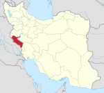
 Location of Ilam Province in Iran | |
| Coordinates: 33°38′18″N 46°25′21″E / 33.6384°N 46.4226°ECoordinates: 33°38′18″N 46°25′21″E / 33.6384°N 46.4226°E | |
| Country |
|
| Region | Region 4 |
| Founded | 1973[1] |
| Capital | Ilam |
| Counties | |
| Government | |
| • Body | Provincial Government |
| • Governor | Qasem Soleimani Dashtaki |
| Area | |
| • Total | 19,086 km2 (7,369 sq mi) |
| [2] | |
| Highest elevation[3] (Kan Seifi Peak) | 3,050 m (10,010 ft) |
| Lowest elevation[4] | 36 m (118 ft) |
| Population (2011)[5] | |
| • Total | 557,599 |
| • Density | 29/km2 (76/sq mi) |
| Time zone | UTC+03:30 (IRST) |
| • Summer (DST) | UTC+04:30 (IRST) |
| Postal code | 69311–69991[6] |
| Area code(s) | +98 84 |
| Vehicle registration | Iran 98[7] |
| Website | Ilam Portal |
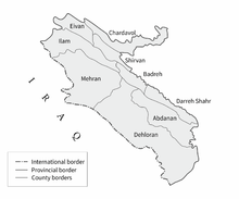
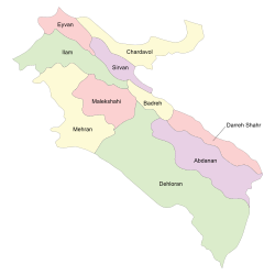
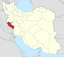
Ilam Province (Persian: استان ایلام) is one of the 31 provinces of Iran. In 2014 it was placed in Region 4.[8] It is in the western part of the country, bordering Iraq. Its provincial center is the city of Ilam. Covering an area of 19,086 square kilometers, it includes Ilam, Mehran, Dehloran, Darreh Shahr, Sarable, Eyvan, Abdanan and Arkwaz cities. Ilam province shares its borders with three neighboring Iranian provinces and Iraq, Khuzestan province in the south, Lurestan province in the east, Kermanshah province in the north, and Iraq in the west with 425 kilometers of common border. The population of the province is approximately 600,000 people (2015 estimate). The counties of Ilam Province are Eyvan County, Chardavol County, Sirvan County, Ilam County, Malekshahi County, Mehran County, Badreh County, Darreh Shahr County, Abdanan County & Dehloran County.
Geography and climate
Ilam province covers an area of 19,086 km2 (7,369 sq mi), about 4.1 percent of the country.[9]
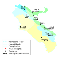
The northwest-southeast alignment of Zagros Mountains forms the terrain of the area. The two important mountain ridges are Kabir Kuh and Dinar Kuh. Being located in the western-most part of Zagross Mountains gives the province its special landscape including deserts in the western counties of Mehran and Dehloran bordering Iraq which feature very hot summers and mild winters and very low precipitations and the mountainous regions of east like Abdanan and Darreh Shahr which are milder and receive higher precipitations, mostly in form of rain, although snow is not rare. The northern region of Ilam, due to its altitude, experiences cold winters and mild summers and receives the highest amount of precipitation in the province. The variety of land is one of the main reasons nomads are prevalent in the area.[9]
People and culture
Ilam is inhabited by various people, with Kurds in the majority with 79.6%, followed by Lurs with 10.7%, Laks (6.1%), Persians (1.8%) and Arabs (1.8%)[10] [11] . In Abdanan, Dehloran, and Mehran the majority of residents speak in Kurdish and Luri respectively. In Darreh Shahr, the majority of residents speak in Laki and Lurish, and there are also some tribes of Lurs such as Shuhans, Seleyverzis and Kaydkhordeh living in the southern and eastern parts of the province. The north is mostly inhabited by Kurdish tribes who speak two dialects: Kalhuri and Feyli.[11] The majority are Feyli, such as those of Khezel, Arkawâzi, Beyrey (Ali Sherwan) and Malek Shahi .[11][12] Almost all residents in Ilam province are Shi'a Muslims.[12]
History
Limited archaeological studies and discoveries indicate 6,000 years of tribal residence in Ilam. Historical evidence indicates that Ilam province was part of the ancient Elamite Empire. In some of the epigraphs left from Sumerian history, this territory was called Alam, Alamo, or Alamto meaning the high lands where the sun rises. In October 2018, officials announced that dozens of historical objects dating back to 1,200 years ago have been discovered during archaeological excavations in the village of Sarab-e Kalan.[13]
The name "Pahla" was also used for the area include Ilam province by the early Muslim geographer until the 13th century, after which when Lurs from Luristan captured the Kurdish populated regions of Ilam (old names: masbazan and Pahlah)[14] and part of Kermanshah provinces the name "Luristan or Pushtkooh" gradually came to replace it. Due to the name of Luristan or Pushtkooh, the Kurdish population in Pushtkooh are called Lur wrongly (Luri speakers can be easily distinguished from feyli Kurdish speakers due to the obvious differences between feyli Kurdish dialect and Luri). Arabic texts recorded the name as "Fahla" or "Bahla", (note: the Arabic language lacks the phoneme /p/). Subsequently, "Fahla" evolved to 'Faila' and 'Faili' -- the modern name of the Pahli Kurds. It is worthy to note that still a small town called 'Pahla' exist in the south of the major city of Ilam, Iran and occupied by Pahli Kurds.[15]'.It was also part of the Achaemenid Empire. Existence of numerous historical vestiges in Ilam province belonging to the Sassanid period indicates the specific importance of the region in that time. In this period Ilam province was divided into two regions, Mehrjankadak in the eastern part and Mâsabazân at the western part.Kurdish tribes governed the region from the late 11th century till the early 13th century. .In the 1930 division of Iran, Ilam became a part of Lorestan, Kermanshah and Khuzestan provinces, only later becoming a province by itself.
Ilam today

During the Iran–Iraq War, Ilam province suffered heavily and Iraq's intense bombings left no economic infrastructure for the province. Ilam thus remains one of Iran's more undeveloped provinces. Ilam's unemployment rate was 19.9% in 2003.
Only in recent years has the central government began investing in advanced industries like Petrochemical facilities, with Japanese help, in Ilam. Ilam also has a bright future in the tourist sector, with 174 historical sites listed under Iran's Cultural Heritage Organization, though it also remains undeveloped.
Colleges and universities
Ilam province contains the following universities:
- Ilam University of Medical Sciences
- University of Ilam
- Islamic Azad University of Ilam
- Payame noor University of Ilam
Attractions
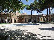
- Imamzadehs: These are shrines mostly from the Middle Ages: Imamzadeh Ali Saleh, Imamzadeh Seyd mammad Abed, Imamzadeh Seyd Akbar, Imamzadeh Seyd Fakhreddin, Imamzadeh Seyd Nasereddin, Imamzadeh Ibrahim, Imamzadeh Abbas, Imamzadeh Abdullah, Imamzadeh Pir Muhammad, Imamzadeh Baba Seifuddin, Imamzadeh Mehdi Saleh, Imamzadeh Ibrahim Qetal, Imamzadeh Seyd Hasan, Imamzadeh Seyd Salaheddin Muhammad, Imamzadeh Haji Bakhtiar, Imamzadeh Haji Hazer, Imamzadeh Jabir.
- Fire Temples (10 in total): These are Zoroastrian shrines from the Sassanid era, now in ruins: Siyahgol Iwan, Chahar Taghi in Darreh Shahr.
- Mansions, forts, and castles (90 in total): Ghal'eh Vali (Qajar era), Posht Ghal'eh Chowar, Ghal'eh Paghela Chekarbuli, Ghal'eh Falahati (Qajar era),Ghal'eh Ghiran (Achaemenid era), Shiagh castle in Dehloran (Sassanid era), Ismail Khan fort, Sam castle (late Parthian era), Pur Ashraf castle, Mir Gholam Hashemi ghal'eh, Posht Ghal'eh Abdanan (Sassanid), Konjancham fort, Shirin and Farhad Iwan in Mehran (Parthian era), Hezar Dar Castle (Sassanid), Sheikh Makan Fort (Sassanid), Zeinal Fort.
- Bridges from Sassanid era (5 in total).
- Numerous archeological sites (Teppes) and ruins from Sassanid era and earlier (224 in total).
- Ancient reliefs scattered across the province (8 in total).
- Ancient urban settlement ruins (22 in total).
- Springs, caves (like the cave of Zinegan), siahgave Abdanan twin lakes, Ilam dam lake , 3 protected natural habitats, and provincial parks.
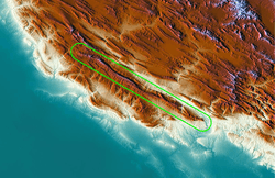
- Tar Spring, in Dehloran.
Tar Spring, Dragon Blood
One of the most interesting things to be found near the city Dehloran is a natural liquid tar spring.[16] Iranians used to use this tar to render ships and roofs waterproof about 3000 years ago. This black spring is located in a natural protected area named Abgarm. Interesting things around this area include mineral water springs, native trees, and bat caves with rare species of bats.
The road to the Black Spring is near city Dehloran and leads to the Abgarm natural protected area. A sign guides visitors to the spring via a narrow road. The last few hundred meters of the road is not suitable for vehicles and requires a short walk to reach to the spring. Visitors will notice the smell of tar as they approach. The spring’s diameter is about 9 meters and hot water full of liquid tar particles flows out of it. There is a fence to protect animals from going nearby and get trapped in the tar.
According to myths told by the native people, this tar spring was the blood of a dragon that was killed by the Iranian hero, Esfandiar.[16]
Notable people
- Darioush Rezaeinejad, nuclear energy scientist, born in Abdanan (Ilam)
See also
References
- ↑ "تاریخچه استان ایلام". تبیان (in Persian). موسسه فرهنگی و اطلاع رسانی تبیان. 14 January 2004. Retrieved 18 September 2015.
- ↑ "اقلیم استان ایلام". پورتال سازمان هواشناسی کشور (in Persian). سازمان هواشناسی کشور. Retrieved 17 September 2015.
- ↑ "قله "کان صیفی" ایلام در هوای برفی فتح شد" (in Persian). Ilam Press. Ilam Press. January 10, 2015. Retrieved 17 September 2015.
- ↑ Google Earth Pro V 7.1.5.1557. Mehran County, Iran. 32° 58’ 53.80”N, 46° 05’ 47.61”E, Eye alt 1760 meters: US Dept of State Geographer. Google 2015. Cnes/Spot Image 2015. December 22, 2002. Archived from the original on September 8, 2010. Retrieved September 18, 2015.
- ↑ Selected Findings of National Population and Housing Census 2011 Archived 2013-05-31 at the Wayback Machine.
- ↑ "کدپستی ۵ رقمی مناطق استان ایلام". سامانه پیامک برتر (in Persian). سامانه پیامک برتر. Archived from the original on 31 August 2015. Retrieved 18 September 2015.
- ↑ "راهنمای کامل شماره پلاک خودرو به تفکیک شهر و استان". Setareh (in Persian). مجله اینترنتی ستاره. May 17, 2015. Retrieved 17 September 2015.
- ↑ "همشهری آنلاین-استانهای کشور به ۵ منطقه تقسیم شدند (Provinces were divided into five regions)". Hamshahri Online (in Persian). 22 June 2014. Archived from the original on 23 June 2014.
- 1 2 "اقلیم استان ایلام". Iran Meteorological Organization.
- ↑ "On Language Distribution in Ilam Province, Iran". Iranian Studies. 48: 835–850. doi:10.1080/00210862.2014.913423.
- 1 2 3 "On Language Distribution in Ilam Province, Iran". Iranian Studies. 48: 835–850. doi:10.1080/00210862.2014.913423.
- 1 2 LookLex Encyclopaedia, retrieved 1 February 2008
- ↑ https://ifpnews.com/exclusive/1200-year-old-relics-discovered-in-irans-ilam-province/
- ↑ http://rch.ac.ir/home
- ↑ Feyli Kurds
- 1 2 "Ilam". ilam.rmto.ir. Retrieved 26 June 2013.
External links
| Wikimedia Commons has media related to Ilam Province. |
- (in Persian) Ilam Province Department of Education
- (in Persian) Ilam Picture Gallery
- Hamid-Reza Hosseini, Shush at the foot of Louvre (Shush dar dāman-e Louvre), in Persian, jadidonline.com, 10 March 2009.
Audio slideshow (6 min 31 sec). - "Images and photos Dehloran - Ilam Ostan". viewphotos.org.
Places adjacent to Ilam Province | |
|---|---|
| Counties and cities |
|  | ||||||||||||||||||
|---|---|---|---|---|---|---|---|---|---|---|---|---|---|---|---|---|---|---|---|---|
| Sights |
| |||||||||||||||||||
| populated places | ||||||||||||||||||||