Darreh Shahr
| Darreh Shahr درهشهر | |
|---|---|
| City | |
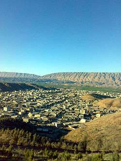 City view to the North | |
 Location in the Ilam province | |
 Darreh Shahr Location in Iran | |
| Coordinates: 33°08′23″N 47°22′34″E / 33.13972°N 47.37611°ECoordinates: 33°08′23″N 47°22′34″E / 33.13972°N 47.37611°E | |
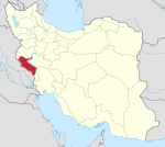
| Country |
|
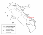
| Province | Ilam |
| County | Darreh Shahr |
| District | Central |
| Neighborhoods |
List
|
| Government | |
| • Governor | Aliakbar Shafizadeh[1] |
| • Mayor | Abbas Derikvand[2] |
| • City Council | Abdol Karam-khodaei[3] |
| Area | |
| • City | 3.05 km2 (1.18 sq mi) |
| Elevation | 660 m (2,170 ft) |
| Highest elevation | 695 m (2,280 ft) |
| Lowest elevation | 635 m (2,083 ft) |
| Population (2016 Census) | |
| • Urban | 21,900 [4] |
| Linguistics[5] | |
| • Language(s) | Persian, Kurdish |
| • Dialect(s) | Lori, Laki |
| Time zone | UTC+03:30 (IRST) |
| • Summer (DST) | UTC+04:30 (IRDT) |
| Postal code | 69611 to 69691 |
| Area code(s) | +98 84 3522 |
| ISO 3166 code | IR-05 |
| Vehicle registration | ٩٨ ط |
| Website | Darreh Shahr Government Office |
Darreh Shahr (Persian: درهشهر)[6] is an Iranian city, capital of Darreh Shahr County, located in the south-eastern part of Ilam Province, in the northern side of Kabir Kuh ranges. As the only city in the county, the 2011 census recorded a population of 24,961, making it the second-largest city in the province.[7] The ruins of the Darreh Shahr Ancient City is located in the south of city. The Darreh Shahr river flows through the city and into the Seymareh river.
The original settlement is believed by many historians to be the summer capital of Elam dynasty which thrived on Sassanid Empire era.[8]
History
In ancient times, Elamites governed the Lorestan mountains and constructed several strong buildings. Darreh Shahr was the first Elamite city attacked and destroyed by Assyrians in addition to the massacre of people. In Seymareh Valley the remains of the Sassanid monuments are still present; hence Darreh Shahr might have been a thriving city in the Sassanid and the Parthian periods. Furthermore, some foreign experts call the unearthed city as the second and lost capital of the Seleucids while some Iranian archaeologists believe that the monuments are part of the state of Sirvan. Referencing some resources and texts, Darreh Shahr may be the same as Mehr Jaan Ghazagh, Saabzaan, Seymareh or the city of Khosrau II in the late Sassanid period completely leveled to earth from an earthquake in the years 248 and 344 A.H.[9]
Despite the fact that there is no strong and reliable evidence to show the first time human being settled in this are, most historians believe that Madakto Ancient City as a city in Sassanid era and because of its proximity to Ctesiphon was in fact a summer capital for kings in that era. Historians also believe the city was founded by Khosrau II. The great and impregnable fortress in east of Ctesiphon mountains that Khosrau II built to protect his family when threatened is believed to be in Darreh Shahr as well.[10]
Hormozan, a ruling king of Sassanid era was from Mehrgan Kade. The city gained its popularity again in Islamic era and was known as Seymareh.[11] There are several archaeological sites round the city that are clear evidences of the importance of this city in ancient times: Bahram Choobin Gorge, Darreh Shahr Fire Temple, Gavmishan Bridge, Jam Namesht Bridge, Koozeh Garan Hill, Majeen Ancient City, Majeen Gorge, Sassanid Bridge, Sheikh Makan Fort and Tikhan Hill.
Darreh Shahr was officially declared a county in 1343 SH (1964-1965). The county has two districts, Central and Majeen. Darreh Shahr is in the Central district.[12] In
The name of the city comes from 'Darreh' (Persian: درّه) meaning 'valley' and 'Shahr' (Persian: شهر) meaning 'city'.
Geography
| Darreh Shahr | ||||||||||||||||||||||||||||||||||||||||||||||||||||||||||||
|---|---|---|---|---|---|---|---|---|---|---|---|---|---|---|---|---|---|---|---|---|---|---|---|---|---|---|---|---|---|---|---|---|---|---|---|---|---|---|---|---|---|---|---|---|---|---|---|---|---|---|---|---|---|---|---|---|---|---|---|---|
| Climate chart (explanation) | ||||||||||||||||||||||||||||||||||||||||||||||||||||||||||||
| ||||||||||||||||||||||||||||||||||||||||||||||||||||||||||||
| ||||||||||||||||||||||||||||||||||||||||||||||||||||||||||||
Darreh Shahr is situated at the transition zone between Kabir Kuh foothills and Seymareh River and alongside Darreh Shahr River which flows from Sarab-e Darreh Shahr to Seymareh river through the town. The town lies within the foothills of eastern side of Kabir Kuh. Its average elevation is 660 m (2,170 ft) above sea level. The city covers a land of about 3.5 km2 (1.4 sq mi).
Climate
Darreh Shahr experiences mild winters and very hot summers.[13] Due to being in Subtropical high pressure zone, Ilam province including Darreh Shahr experiences a relatively static thermal condition but proximity to large deserts like Arabian Desert and Iraqi Desert brings several heat waves in summers. However, Mediterranean and Sudan low pressure air masses bring intense precipitation and thundershowers in winters. The long-term average annual precipitation is about 402 mm (15.8 in).[14][15]
| Climate data for Darreh Shahr | |||||||||||||
|---|---|---|---|---|---|---|---|---|---|---|---|---|---|
| Month | Jan | Feb | Mar | Apr | May | Jun | Jul | Aug | Sep | Oct | Nov | Dec | Year |
| Record high °C (°F) | 20.8 (69.4) |
25.6 (78.1) |
29.6 (85.3) |
34.4 (93.9) |
42.2 (108) |
46.6 (115.9) |
49 (120) |
48.8 (119.8) |
46.6 (115.9) |
38.4 (101.1) |
30.2 (86.4) |
25.6 (78.1) |
49 (120) |
| Average high °C (°F) | 9.9 (49.8) |
12.1 (53.8) |
17.0 (62.6) |
22.7 (72.9) |
28.2 (82.8) |
35.2 (95.4) |
39.0 (102.2) |
39.1 (102.4) |
33.9 (93) |
26.8 (80.2) |
18.2 (64.8) |
11.9 (53.4) |
21.2 (70.2) |
| Daily mean °C (°F) | 9.0 (48.2) |
10.5 (50.9) |
14.8 (58.6) |
20.8 (69.4) |
28.1 (82.6) |
35.6 (96.1) |
38.4 (101.1) |
37.1 (98.8) |
32.3 (90.1) |
24.0 (75.2) |
13.2 (55.8) |
10.4 (50.7) |
22.85 (73.13) |
| Average low °C (°F) | −1.2 (29.8) |
1.1 (34) |
4.1 (39.4) |
7.9 (46.2) |
11.8 (53.2) |
16.0 (60.8) |
19.9 (67.8) |
20.1 (68.2) |
14.2 (57.6) |
9.9 (49.8) |
5.0 (41) |
1.1 (34) |
9.05 (48.29) |
| Record low °C (°F) | −4.4 (24.1) |
−3.4 (25.9) |
0.8 (33.4) |
−2.6 (27.3) |
8.8 (47.8) |
10.8 (51.4) |
20.0 (68) |
21.6 (70.9) |
12.0 (53.6) |
6.0 (42.8) |
−1.4 (29.5) |
−3.2 (26.2) |
−4.4 (24.1) |
| Average precipitation mm (inches) | 69.5 (2.736) |
72.0 (2.835) |
49.2 (1.937) |
55.9 (2.201) |
11.4 (0.449) |
0.2 (0.008) |
0.1 (0.004) |
0.1 (0.004) |
1.0 (0.039) |
25.5 (1.004) |
56.9 (2.24) |
60.2 (2.37) |
402 (15.827) |
| Average precipitation days (≥ 1.0 mm) | 9. | 9.4 | 10.1 | 8.7 | 3.9 | 0.4 | 0.3 | 0.1 | 0.0 | 3.1 | 6.3 | 8.2 | 59.5 |
| Average relative humidity (%) | 59 | 66 | 55 | 37 | 34 | 20 | 21 | 23 | 27 | 31 | 63 | 67 | 42 |
| Mean monthly sunshine hours | 188.9 | 178.8 | 187.5 | 224.6 | 260.4 | 316.4 | 313.8 | 323.1 | 262.9 | 286.9 | 199.8 | 224.5 | 2,967.6 |
| Source: I.R. of Iran Meteorological Organization | |||||||||||||
Parks
There are four parks in and around the city:
- Laleh Park is a very small park located on Imam Khomeini Blvd, yet it is the oldest in the city established before the Iranian Revolution.
- Shahrdari Park, is a 2.75 hectares green space on Imam Hossein Str.
- Kowsar Forest Park is a 60-hectare man-made forest of Eucalyptus trees on the eastern hillsides of the city.
- Sarab is located 5 km out of the city and is built around the Sarab Spring which provides the drinking water for the city and nearby communities.[16]
Economy
Darreh Shahr economy is mainly based on agriculture, orchards and ranching. Water for agriculture purposes is supplied from wells, springs and the Seymareh river. Agricultural products include: wheat, barley, cucumber, cantaloupe, honeydew, watermelon, legume, corn, fodder, rice, sesame, vegetables, pomegranate, grapes, and fig.[17]
Darreh Shahr Industrial Park is located 11 km (6.8 mi) out of the city along the Darreh Shahr-Pol-e Dokhtar road.There are still 17 small industries in the park.[18]
Handicraft is the main industry in Ilam province included Darreh Shahr.[8] "Ilam carpet is one of the most distinguished carpets of our country." Alikhani, head of Iranian National Carpet Company said addressing the head of Ilam Industry, Mine and Trade Organization.[19]
"Ilam includes top provinces in terms of the number of weavers. Its carpet is of optimum condition that is going to be developed more than ever by more protection."[19] "Ilam carpet has a historic precedence and favorable capacities." Head of Ilam Industry, Mine and Trade Organization said.[19]
The main handicraft products are hand-made rugs and carpets. Darreh Shahr county has about 2,000 active weavers and they annually create about 1,200 m2 (13,000 sq ft) rugs and hand-made carpets.[20]
Culture
Darreh Shahr is known as the tourism center of Ilam province[21] due to a wealth of nearby historical attraction and its rather warm climate in spring which brought as many as 244,000 tourists in spring of 2016.[22]
Darreh Shahr also hosts the only archaeological museum in the Ilam province. The Darreh Shahr Museum is located on Imam Khomeini Blvd between the Darreh Shahr Ancient City entrance and the Darreh Shahr Public Library. Most of the articles in the Darreh Shahr Museum belong to Parthian Empire, Sasanian Empire, 1st millennium BCE and the Islamic era.[23]
Historical Attractions
The most prominent attractions in and around the city are:
Darreh Shahr Ancient City is located in south-eastern part of the present Darreh Shahr. It is among the largest historical sites in Ilam province. It is about 200 acres and is one of the first places registered on National Historical Places of Iran. It belongs to Sassanids era. There are remains of buildings, walls, fortresses and bazaars in the area. Walls mostly consist of stone, concrete and plaster. based on the shape of buildings, materials and earthenware in and around the area, Darreh Shahr Ancient City belongs to late Sassanid era.[24] It is believed that the city was destroyed on 334 AH (945-946) due to a catastrophic earthquake.[24]
Darreh Shahr Fire Temple is a four-arched building which is locally called Taaq (Persian: تاق). The building was originally constructed by rubble stone and gypsum, and has recently been repaired.[25]
Transportation
Darreh Shahr Terminal is the main passengers terminal. It provides daily services to Pol Dokhtar, Dezful, Andimeshk, Abdanan and Ilam by taxi. In the past services were generally provided by minibuses. Darreh Shahr Bus Terminal provides daily services to major cities such as Tehran, Isfahan, Ahvaz.
The city has no inland navigable waterways. A disused small tarmac airstrip exists in the south of the city. It was used by agricultural aircraft, nowadays it is mostly used by people who want to learn driving.
The city is connected to neighboring towns, Ilam, Pol Dokhtar and Abdanan by three main roads. The Darreh Shahr–Ilam route has undergone development projects. Since the beginning of the project about 62 km (39 mi) have been turned into 2+1 highway with reversible lane. The state government has spent $21M so far and it requires $35M more to finish the project.[26]
Kabir Kuh Tunnel is a long road tunnel under the Kabir Kuh range connecting the two sides of the range. It is going to serve as main route to border crossings of Mehran, Dehloran and the holy sites in Iraq which are of importance to the Iranian government. As of June 2016, 2,400 m (7,900 ft) in total has been dug of the main tunnel mainly from the west side. The tunnel is ultimately going to be 4,800 m (15,700 ft) in length. It is in fact the longest under-development road tunnel in Iran.[27][28][29][30]
Sports
Darreh Shahr has offered many great athletes over time in a variety of sports such as the Martial arts, Wrestling, Volleyball, Football, Boxing and Athletics.
In TKD, the most renowned figures are, Seyed Ali Seydi and Jalal Yari with silver and bronze medals in national taekwondo competitions and many gold medals at provincial level. According to Ilam Province Taekwondo Board, Seyed Ali Seyedi and Jalal Yari are the 1st and 3rd best trainers in the province.[31]
There are many sports schools in the city:
Education
Darreh Shahr County Education Administration supervises all the schools in the county including Darreh Shahr itself.
Universities:
- Islamic Azad University of Darreh Shahr[34]
- University of Applied Science and Technology of Darreh Shahr[35]
- Payame Noor University of Darreh Shahr[36]
High schools in the city are as follows:[37]
- Shahid Motahari Public Boys'
- Bagher-al Olum Public Boys'
- Hazrat Zeinab Public Girls'
- Fatemieh Public Girls'
- Imam Khomeini Private Boys'
- Tohid Private Boys'
- Mobtakeran Private Boys'
- Shayesteghan Private Girls'
References
- ↑ "اولین فرماندار بومی در شهرستان دره شهر منصوب شد". www.dana.ir. Retrieved 2017-08-20.
- ↑ "شهردار دره شهر منصوب شد | پایگاه خبری تحلیلی ایلام بیدار". ilamebidar.ir. Retrieved 2017-08-20.
- ↑ "اعضای شورای شهر دره شهر مشخص شدند". خبرگزاری مهر | اخبار ایران و جهان | Mehr News Agency (in Persian). 2017-05-20. Retrieved 2017-08-20.
- ↑ https://www.amar.org.ir/english
- ↑ "جاذبه های شهرستان دره شهر". Retrieved 29 July 2013.
- ↑ Darreh Shahr can be found at GEOnet Names Server, at this link, by opening the Advanced Search box, entering "-3059816" in the "Unique Feature Id" form, and clicking on "Search Database".
- ↑ 1390, سرشماری عمومی نفوس و مسکن. "سرشماری عمومی نفوس و مسکن 1390 > نفوس و مسکن > سرشماری 1385 > نتایج سرشماری 85 > جداول منتخب 85". liveweb.archive.org (in Persian). Archived from the original on 2012-11-15. Retrieved 2017-07-26.
- 1 2 اطلس ایران وجهان. "دانستنیها ی تاریخ وجغرافیایی ایران وجهان".
- ↑ "Dareh Shahr, the summer capital of Elamites". tehrantimes.com. Tehran, Iran: Tehran Times. 20 April 2013. Retrieved 13 June 2014.
- ↑ Rawlinson, Sir Henry (1839). "Notes on a March from Zoháb, at the Foot of Zagros, along the Mountains to Khúzistán (Susiana), and from Thence Through the Province of Luristan to Kirmánsháh, in the Year 1836". The Journal of the Royal Geographical Society. 9. Retrieved 25 July 2013.
- ↑ ایزدپناه, حمید (1998). تاریخ جغرافیایی واجتماعی لرستان (مقدمه ای بر آثار باستانی وتاریخی لرستان). انجمن آثار و مفاخر ملی آیران.
- ↑ "آشنایی با شهرستان دره شهر". فرمانداری دره شهر. Retrieved 27 July 2013.
- ↑ "اقلیم استان ایلام". Retrieved 26 July 2013.
- ↑ http://www.ilammet.ir/geo.asp
- ↑ گزارش بارندگی ۲۴ ساعت گذشته ایستگاه های هواشناسی استان (PDF). ilammet.ir/ (in Persian). اداره کل هواشناسی استان ایلام. 2014. p. 1. Retrieved 6 June 2014.
- ↑ "دره شهر گنجینه ای گمشده در اعماق تاریخ - پارک های دره شهر". shahrema.blogfa.com. Retrieved 2017-08-20.
- ↑ "جاذبه هاش شهرستان دره شهر". Retrieved 26 July 2013.
- ↑ "شهرک صنعتی دره شهر". Retrieved 26 July 2013.
- 1 2 3 Administrator. "Ilam Carpet, One of the Most Distinguished Carpets".
- ↑ ".:: www.ilamToday.com .::. ايلام امروز ::".
- ↑ سیما, IRIB NEWS AGENCY | خبرگزاری صدا و. "دره شهر قطب گردشگری ایلام". IRIB NEWS AGENCY | خبرگزاری صدا و سیما (in Persian). Retrieved 2017-08-18.
- ↑ "تنگه بهرام چوبین دره شهر پذیرای بیشترین گردشگر در تعطیلات نوروزی". خبرگزاری جمهوری اسلامی (in Persian). Retrieved 2017-08-18.
- ↑ "استقبال گردشگران نوروزی از تنها موزه باستان شناسی استان ایلام در دره شهر". خبرگزاری جمهوری اسلامی (in Persian). Retrieved 2017-08-18.
- 1 2 "اماکن زیارتی، تفریحی و جاذبه های گردشگری درهشهر". Retrieved 27 July 2013.
- ↑ "Dareh Shahr tourism attractions". Iran Tourism & Touring Online. Iran Tourism & Touring Online Website. Retrieved 28 July 2013.
- ↑ "استاندار ايلام از پروژه هاي راهسازي ايلام- دره شهر بازدید کرد". ilamefarda. ilamefarda.ir. Retrieved 27 December 2013.
- ↑ روابطعمومي ادارهكل راه و شهرسازي استان ايلام. "200 متر از تونل كبيركوه در مسير آبدانان- دره شهر استان ايلام حفاري شد". I.R. of Iran Road Maintenance and Transportation Organization website. Retrieved 27 December 2013.
- ↑ از سر گرفته شدن عملیات اجرایی تونل کبیرکوه. yjc.ir (in Persian). 9 April 2014. Retrieved 6 June 2014.
- ↑ "تونل کبیرکوه دومین مسیر تردد به عتبات عالیات". خبر مرکز ایلام (in Persian). IRIB Ilam. Retrieved 17 September 2015.
- ↑ "حفاری ۲۴۰۰ متری تونل کبیرکوه آبدانان/نیاز ۱۲۰۰ میلیاردی پروژه". خبرگزاری مهر | اخبار ایران و جهان | Mehr News Agency (in Persian). 2016-06-07. Retrieved 2017-07-26.
- ↑ "برترین مربیان استان ایلام معرفی شدند | فدراسیون تکواندو". www.iritf.org.ir. Retrieved 2017-08-25.
- 1 2 3 "مدارس فوتبال دره شهر-استان ایلام". مدرسه نیوز - مرجع نمونه سوال مدرسه (in Persian). Retrieved 2017-08-24.
- 1 2 "سایت حامیان تکواندو دره شهر". tkdssn.blogfa.com. Retrieved 2017-08-24.
- ↑ "دانشگاه آزاد اسلامی واحد دره شهر – دانشگاه آزاد اسلامی واحد دره شهر". iau-dar.ac.ir (in Persian). Retrieved 2017-07-26.
- ↑ "مرکز آموزش عالی علمی کاربردی دره شهر". مرکز آموزش عالی علمی کاربردی دره شهر. Retrieved 2017-07-26.
- ↑ "پورتال دانشگاه پیام نور-دره شهر-ایلام". dareh.ilam.pnu.ac.ir. Retrieved 2017-07-26.
- ↑ "اسامی دبیرستان های متوسطه دوم شهرستان دره شهر - فـــلـــســــفـــه". d-babaeian.persianblog.ir. Retrieved 2017-07-26.
External links
| Wikimedia Commons has media related to Darreh Shahr. |
| Counties and cities |
|  | ||||||||||||||||||
|---|---|---|---|---|---|---|---|---|---|---|---|---|---|---|---|---|---|---|---|---|
| Sights |
| |||||||||||||||||||
| populated places | ||||||||||||||||||||