Cunit
| Cunit, Baix Penedès | |||
|---|---|---|---|
| Municipality | |||
 | |||
| |||
 Location of Cunit within Baix Penedès, Catalonia. | |||
 Cunit, Baix Penedès Location in Catalonia | |||
| Coordinates: 41°11′54″N 1°38′26″E / 41.19833°N 1.64056°ECoordinates: 41°11′54″N 1°38′26″E / 41.19833°N 1.64056°E | |||
| Country | Spain | ||
| Government | |||
| • mayor | Montserrat Carreras García (2015)[1] | ||
| Area[2] | |||
| • Total | 9.7 km2 (3.7 sq mi) | ||
| Elevation | 10 m (30 ft) | ||
| Population (2014)[1] | |||
| • Total | 11,989 | ||
| • Density | 1,200/km2 (3,200/sq mi) | ||
| Postal code | 43881 | ||
| Area code(s) | 977 | ||
| Website |
cunit | ||


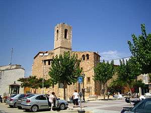
Cunit is a coastal town on the Golden Coast (Costa Daurada in Catalan) in the Baix Penedès region part of the province of Tarragona in Catalonia, Spain. It is on the northeast coast of Spain on the Mediterranean Sea.
Location and site
It is located in the district of Baix Penedès and the province of Tarragona but is included in the third crown of the Urban Region of Barcelona. Bordered by Segur de Calafell (location of the municipality of Calafell), in the same area, as well as Cubelles in the district of Garraf and Castellet i la Gornal in the region of Alt Penedès, both from the province of Barcelona.
History, culture and art
Cunit origins date back to prehistoric times, with archaeological remains found dating back to 3700 BC.
First settlers
The first settlers are documented in a total of six well-documented sources.
This is a large and dispersed settlement. It is similar to neighbouring coastal settlements of the Baix Penedès which used to trade a great deal with punicobusitans traders. A relationship that no doubt had its own weight in the transformation of the habits and customs of the early settlers.
Land
Architectural heritage and Edificio Los Diamantes
Demographics
The 1590, although the town had been almost depopulated by the incursions of the Saracen pirates and Turkey (1581), the Mas of Vilaseca remained populated. There are also references to a fishing settlement on the beach, documented in 1638 in 1670, residents from time immemorial were licensed to fish on Sundays and religious holidays, on payment of a stipend of one tenth of the catch to the local parish.
From 1960, Cunit began to become a summer vacation centre for the BarcelonaMetropolitan Area. At the same time, it started to become a major residential area of the Golden Coast
Climate
Mediterranean climate provides mild winters and hot summers.
| Climate data for Cunit | |||||||||||||
|---|---|---|---|---|---|---|---|---|---|---|---|---|---|
| Month | Jan | Feb | Mar | Apr | May | Jun | Jul | Aug | Sep | Oct | Nov | Dec | Year |
| Average high °F (°C) | 62.8 (17.1) |
67.6 (19.8) |
72.1 (22.3) |
73.8 (23.2) |
81 (27.2) |
82.6 (28.1) |
89.2 (31.8) |
90.3 (32.4) |
84.7 (29.3) |
79.9 (26.6) |
73.8 (23.2) |
67.5 (19.7) |
77.1 (25.1) |
| Average low °F (°C) | 35.1 (1.7) |
34.9 (1.6) |
37.2 (2.9) |
43 (6.1) |
53.2 (11.8) |
54 (12.2) |
65.5 (18.6) |
63.3 (17.4) |
56.5 (13.6) |
55.6 (13.1) |
45.7 (7.6) |
36.9 (2.7) |
48.4 (9.1) |
| Average precipitation inches (mm) | 5.252 (133.4) |
0.181 (4.6) |
0.26 (6.6) |
0.252 (6.4) |
0.677 (17.2) |
0.079 (2.0) |
0.055 (1.4) |
1.22 (31.0) |
3.874 (98.4) |
1.48 (37.6) |
0.236 (6.0) |
1.268 (32.2) |
14.834 (376.8) |
| Source: Darrera[3] | |||||||||||||
Environment
Beaches
One of the main attractions of the town are the 2 and a half kilometers of sandy beaches in the form of golden beaches, protected by seven longitudinal breakwaters and four in the form of islands. These breakwaters had to be built in the early 1980s due to construction of the reservoir of Foix and the ports of Cubelles (to the north) and Segur de Calafell (to the south) which caused a disruption of the morphodynamic equilibrium, the effect being a visible loss of the beaches. Since 1997 it has been receiving the award of blue flag given by the European Foundation for Environmental Education.[4]
Coast management
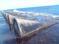

The concentration of large environmental infrastructure on the territory and the coast, as the future Cubelles marina,[5][6] the existence of a combined cycle thermal plant, the location of a desalination plant [7] has opened a debate that includes a beach protection enhancement project developed for the Spanish Coastal Authority following guidelines for littoral enhancement set by the Ministry of the Environment's coastal zone management plan. This long stretch of beach constitutes probably the most important asset of the Municipality of Cunit which relies on tourism as the main income source. The coastal front development combined with beach erosion in the 1980s resulted in beach protection with detached breakwaters creating a series of pocket beaches. Despite to the strong armouring of the coast, erosion problems are still evident and critical at some points of the coast, as well as flooding. On the other hand, the existing structures represent also a hazardous condition for swimmers. As a result, a critical analysis of the existing structures has been overtaken, which together with detailed analysis of the coastal processes, have allowed to provide a new solution, replacing the hard structures with soft protection.
Currently awaiting to receive the report on the management of beaches commissioned the University of Cantabria to adopt a solution to the coastal areas of Cunit.
Seabed
World Wide Fund for Nature proposes to town for inclusion in the official lists of Site of Community Importance for the maritime grasslands described as Posidonia oceanica.
References
- 1 2 "Ajuntament de Cunit". Generalitat of Catalonia. Retrieved 2015-11-13.
- ↑ "El municipi en xifres: Cunit". Statistical Institute of Catalonia. Retrieved 2015-11-23.
- ↑ Weather averages of Cunit Metereologic Station 2006
- ↑ Blue Flag Marina
- ↑ Official project
- ↑ http://www.ereventos.com/02_proyectos/proyecto.jsp?id_proyecto=220 Cubelles marina
- ↑ Desalination Plant
External links
- Government data pages (in Catalan)
Places adjacent to Cunit | |
|---|---|
Municipalities of Baix Penedès | ||
|---|---|---|