El Pla de Santa Maria
| El Pla de Santa Maria | |||
|---|---|---|---|
| Municipality | |||
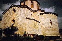 St. Ramon's church | |||
| |||
 El Pla de Santa Maria Location in Catalonia | |||
| Coordinates: 41°21′45″N 1°17′29″E / 41.36250°N 1.29139°E | |||
| Country |
| ||
| Community |
| ||
| Province | Tarragona | ||
| Comarca | Alt Camp | ||
| Government | |||
| • Mayor | Mateu Montserrat Miquel (2015)[1] | ||
| Area[2] | |||
| • Total | 35.0 km2 (13.5 sq mi) | ||
| Elevation | 381 m (1,250 ft) | ||
| Population (2014)[1] | |||
| • Total | 2,344 | ||
| • Density | 67/km2 (170/sq mi) | ||
| Demonym(s) | Planenc | ||
| Website |
www | ||

El Pla de Santa Maria is a municipality in the comarca of the Alt Camp in Catalonia, Spain. It is situated at the foot of the Miramar range. The municipality is served the A-2 autopista and is linked to Valls by the T-200 road.
References
- 1 2 "Ajuntament del Pla de Santa Maria". Generalitat of Catalonia. Retrieved 2015-11-13.
- ↑ "El municipi en xifres: El Pla de Santa Maria". Statistical Institute of Catalonia. Retrieved 2015-11-23.
External links
- Official website (in Catalan)
- Government data pages (in Catalan)
Places adjacent to El Pla de Santa Maria | ||||||||||
|---|---|---|---|---|---|---|---|---|---|---|
| ||||||||||
Municipalities of Alt Camp | ||
|---|---|---|
This article is issued from
Wikipedia.
The text is licensed under Creative Commons - Attribution - Sharealike.
Additional terms may apply for the media files.