Garcia, Tarragona
| Garcia | ||
|---|---|---|
| Municipality | ||
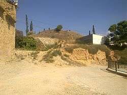 Garcia castle | ||
| ||
 Garcia Location in Catalonia | ||
| Coordinates: 41°8′19″N 0°39′5″E / 41.13861°N 0.65139°ECoordinates: 41°8′19″N 0°39′5″E / 41.13861°N 0.65139°E | ||
| Country |
| |
| Community |
| |
| Province | Tarragona | |
| Comarca | Ribera d'Ebre | |
| Government | ||
| • mayor | Blanca López Quiñones (2015)[1] | |
| Area[2] | ||
| • Total | 52.4 km2 (20.2 sq mi) | |
| Elevation | 73 m (240 ft) | |
| Population (2014)[1] | ||
| • Total | 559 | |
| • Density | 11/km2 (28/sq mi) | |
| Demonym(s) | Garcià, garciana | |
| Website |
www | |

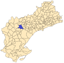
Garcia is a Spanish municipality in the Catalan comarca of Ribera d'Ebre, whose territory extends over both sides of the Ebre river.
History and archaeology
Garcia has been a site of human occupation at least since ancient Iberian times.[3]
The area was reconquered from the Moors in 1153, by count Ramon Berenguer IV of Barcelona. In medieval times the town was part of the Barony of Entença.
According to an 1156 document by which Ramon Berenguer IV ceded the territory to the Poblet Monastery, Garcia was linked to neighboring El Molar town. This situation ended in the 19th century.
Economy
Traditionally, the predominant activity has always been agriculture. On the irrigated land, vegetables and fruit trees are grown, while on the unirrigated terrain, vines, hazelnuts and olives are cultivated. Pigs and chickens are also reared.
References
- 1 2 "Ajuntament de Garcia". Generalitat of Catalonia. Retrieved 2015-11-13.
- ↑ "El municipi en xifres: Garcia". Statistical Institute of Catalonia. Retrieved 2015-11-23.
- ↑ Portal de Garcia
External links
| Wikimedia Commons has media related to Garcia. |
- Garcia Town Hall webpage
- Government data pages (in Catalan)
Places adjacent to Garcia, Tarragona | |
|---|---|
Municipalities of Ribera d'Ebre | ||
|---|---|---|