Császártöltés
| Császártöltés Tschaasartet/Kaiserdamm | |
|---|---|
 Császártöltés Tschaasartet/Kaiserdamm | |
| Coordinates: 46°25′N 19°11′E / 46.417°N 19.183°E | |
| Country |
|
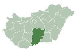
| County | Bács-Kiskun |
| Area | |
| • Total | 82.06 km2 (31.68 sq mi) |
| Population (2005) | |
| • Total | 2,662 |
| • Density | 32.43/km2 (84.0/sq mi) |
| Time zone | UTC+1 (CET) |
| • Summer (DST) | UTC+2 (CEST) |
| Postal code | 6239 |
| Area code(s) | 78 |
Császártöltés is a village in Bács-Kiskun county, in the Southern Great Plain region of southern Hungary.
Croats in Hungary call this village Tetiš or Tuotiš.[1] Germans in Hungary call this village Tschasartet or Kaiserdamm.
Geography
It covers an area of 82.06 km2 (32 sq mi) and has a population of 2,662 people (2005).
References
- ↑ (in Croatian) "Folia onomastica croatica 14/2005". (462 KB) Živko Mandić: Hrvatska imena naseljenih mjesta u Madžarskoj,

This article is issued from
Wikipedia.
The text is licensed under Creative Commons - Attribution - Sharealike.
Additional terms may apply for the media files.