Bácsszőlős
| Bácsszőlős | |
|---|---|
 Bácsszőlős Bácsszőlős | |
| Coordinates: 46°09′00″N 19°27′00″E / 46.1500°N 19.4500°E | |
| Country |
|
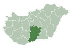
| County | Bács-Kiskun |
| Area | |
| • Total | 38.83 km2 (14.99 sq mi) |
| Population (2005) | |
| • Total | 412 |
| • Density | 10.61/km2 (27.5/sq mi) |
| Time zone | UTC+1 (CET) |
| • Summer (DST) | UTC+2 (CEST) |
| Postal code | 6425 |
| Area code(s) | 79 |
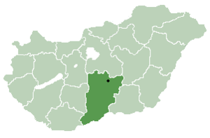
Location of Bács-Kiskun
county in Hungary
Bácsszőlős (Croatian: Prlković, also Perleković and Crvena šuma[1]) is a village and municipality in Bács-Kiskun county, in the Southern Great Plain region of southern Hungary.
Geography
It covers an area of 38.83 km2 (15 sq mi) and has a population of 412 people (2005).
Trivia
2006, this village won the county award for the best decorated village (with flowers).[2]
References
- ↑ Živko Mandić: Hrvatska imena naseljenih mjesta u Mađarskoj, Folia onomastica croatica 14, 2005 (in Croatian)
- ↑ "Hrvatski glasnik br. 40/2006" (PDF). Archived from the original (PDF) on 2007-06-06. (1.37 MB) Cvjetno naselje (in Croatian)
External links
- Bácsszőlős Önkormányzatának honlapja (in Hungarian)
Coordinates: 46°09′N 19°27′E / 46.150°N 19.450°E
This article is issued from
Wikipedia.
The text is licensed under Creative Commons - Attribution - Sharealike.
Additional terms may apply for the media files.