Columbine, Colorado
| Columbine, Colorado | |
|---|---|
| Census-designated place | |
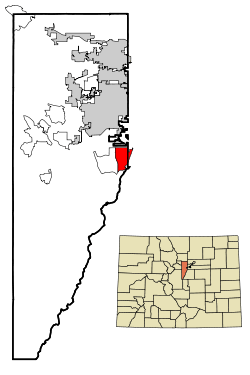 Location in Jefferson County and the state of Colorado | |
| Coordinates: 39°35′16″N 105°4′10″W / 39.58778°N 105.06944°WCoordinates: 39°35′16″N 105°4′10″W / 39.58778°N 105.06944°W | |
| Country | United States |
| State | Colorado |
| Counties | Arapahoe, Jefferson |
| Government | |
| • Type | unincorporated community |
| Area | |
| • Total | 6.78 sq mi (17.55 km2) |
| • Land | 6.65 sq mi (17.22 km2) |
| • Water | 0.13 sq mi (0.33 km2) |
| Elevation[1] | 5,538 ft (1,688 m) |
| Population (2010) | |
| • Total | 24,280 |
| • Density | 3,651/sq mi (1,409.6/km2) |
| Time zone | UTC-7 (MST) |
| • Summer (DST) | UTC-6 (MDT) |
| ZIP Code | 80128 |
| Area code(s) | Both 303 and 720 |
| FIPS code | 08-16110 |
| GNIS feature ID | 1867080 |
Columbine is a census-designated place (CDP) in Arapahoe and Jefferson counties in the U.S. state of Colorado. Located mostly in Jefferson County, it lies immediately west of Littleton.
The population was 24,280 at the 2010 census.[2] Columbine High School, made infamous by the Columbine High School massacre, is located in the community. The ZIP codes for the community are 80123 and 80128.[3]
Geography
Columbine is located on the eastern edge of Jefferson County at 39°35′16″N 105°04′10″W / 39.58778°N 105.06944°W (39.587887, -105.069332),[4] with a small portion extending east into Arapahoe County. Columbine is bordered to the east by Littleton and Columbine Valley, and to the west by Ken Caryl. The Denver city limits are 0.3 miles (0.48 km) north of the northern border of Columbine, and to the south the community extends as far as the Chatfield Reservoir dam.
According to the United States Census Bureau, the Columbine CDP has a total area of 6.78 square miles (17.55 km2), of which 6.65 square miles (17.22 km2) are land and 0.13 square miles (0.33 km2), or 1.86%, are water.[2]
Demographics
| Historical population | |||
|---|---|---|---|
| Census | Pop. | %± | |
| 1980 | 23,523 | — | |
| 1990 | 23,969 | 1.9% | |
| 2000 | 24,095 | 0.5% | |
| 2010 | 24,280 | 0.8% | |
| U.S. Decennial Census[5] | |||
As of the census[6] of 2000, there were 24,095 people, 8,656 households, and 6,933 families residing in the CDP. The population density was 3,629.6 people per square mile (1,401.1/km²). There were 8,800 housing units at an average density of 1,325.6 per square mile (511.7/km²). The racial makeup of the CDP was 94.82% White, 0.47% African American, 0.40% Native American, 1.16% Asian, 0.12% Pacific Islander, 1.57% from other races, and 1.46% from two or more races. Hispanic or Latino of any race were 5.58% of the population.
There were 8,656 households out of which 38.1% had children under the age of 18 living with them, 69.7% were married couples living together, 7.3% had a female householder with no husband present, and 19.9% were non-families. 15.8% of all households were made up of individuals and 3.9% had someone living alone who was 65 years of age or older. The average household size was 2.77 and the average family size was 3.11.
In the CDP, the population was spread out with 27.0% under the age of 18, 6.5% from 18 to 24, 28.0% from 25 to 44, 29.3% from 45 to 64, and 9.2% who were 65 years of age or older. The median age was 39 years. For every 100 females, there were 99.6 males. For every 100 females age 18 and over, there were 96.3 males.
The median income for a household in the CDP was $71,319, and the median income for a family was $77,866 (these figures had risen to $78,203 and $88,515 respectively as of a 2007 estimate[7]). Males had a median income of $51,300 versus $35,713 for females. The per capita income for the CDP was $28,471. About 1.6% of families and 2.0% of the population were below the poverty line, including 2.7% of those under age 18 and 2.2% of those age 65 or over.
See also
References
- ↑ "US Board on Geographic Names". United States Geological Survey. 2007-10-25. Retrieved 2008-01-31.
- 1 2 "Geographic Identifiers: 2010 Census Summary File 1 (G001): Columbine CDP, Colorado". American Factfinder. U.S. Census Bureau. Retrieved April 25, 2018.
- ↑ Columbine, CO: city-data.com
- ↑ "US Gazetteer files: 2010, 2000, and 1990". United States Census Bureau. 2011-02-12. Retrieved 2011-04-23.
- ↑ "Census of Population and Housing". Census.gov. Retrieved June 4, 2016.
- ↑ "American FactFinder". United States Census Bureau. Archived from the original on 2013-09-11. Retrieved 2008-01-31.
- ↑ Columbine CDP, CO: American Community Survey
External links
Municipalities and communities of Arapahoe County, Colorado, United States | ||
|---|---|---|
| Cities | 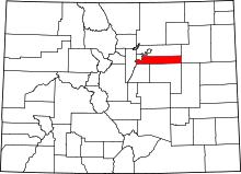 | |
| Towns | ||
| CDPs | ||
| Footnotes | ‡This populated place also has portions in an adjacent county or counties | |
Municipalities and communities of Jefferson County, Colorado, United States | ||
|---|---|---|
| Cities | 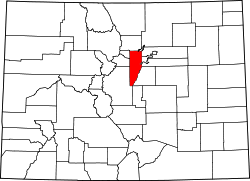 | |
| Towns | ||
| CDPs | ||
| Unincorporated communities | ||
| Ghost town | ||
| Footnotes | ‡This populated place also has portions in an adjacent county or counties | |