Colebrookdale Township, Berks County, Pennsylvania
| Colebrookdale Township | |
|---|---|
| Township | |
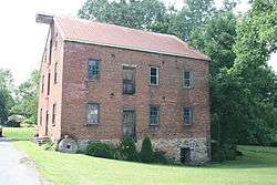 Nicholas Johnson Mill, built 1861 | |
 Location of Colebrookdale Township in Berks County | |
 Colebrookdale Township Location of Colebrookdale Township in Pennsylvania  Colebrookdale Township Colebrookdale Township (the US) | |
| Coordinates: 40°20′30″N 75°37′19″W / 40.34167°N 75.62194°WCoordinates: 40°20′30″N 75°37′19″W / 40.34167°N 75.62194°W | |
| Country | United States |
| State | Pennsylvania |
| County | Berks |
| Area[1] | |
| • Total | 8.46 sq mi (21.91 km2) |
| • Land | 8.42 sq mi (21.81 km2) |
| • Water | 0.04 sq mi (0.09 km2) |
| Elevation | 338 ft (103 m) |
| Population (2010) | |
| • Total | 5,078 |
| • Estimate (2016)[2] | 5,052 |
| • Density | 599.86/sq mi (231.62/km2) |
| Time zone | UTC-5 (EST) |
| • Summer (DST) | UTC-4 (EDT) |
| Area code(s) | 610 |
| FIPS code | 42-011-14984 |
Colebrookdale Township is a township in Berks County, Pennsylvania, United States. The population was 5,078 at the 2010 census.
History
The Bahr Mill Complex and Nicholas Johnson Mill were listed on the National Register of Historic Places in 1990.[3]
Geography
According to the United States Census Bureau, the township has a total area of 8.4 square miles (22 km2), all of it land. It is drained by the Schuylkill River via the Manatawny Creek and tributaries of the Perkiomen Creek. Its villages include Englesville (also in Montgomery County,) Gablesville, and New Berlinville.
Adjacent municipalities
- Douglass Township, Berks County (south)
- Earl Township (west)
- Pike Township (north)
- Washington Township (northeast)
- Douglass Township, Montgomery County (southeast)
Colebrookdale Township surrounds the borough of Boyertown on three sides.
Demographics
As of the census[4] of 2000, there were 5,270 people, 1,994 households, and 1,529 families residing in the township. The population density was 629.3 people per square mile (243.1/km²). There were 2,030 housing units at an average density of 242.4/sq mi (93.6/km²). The racial makeup of the township was 98.69% White, 0.19% African American, 0.08% Native American, 0.34% Asian, 0.13% Pacific Islander, 0.08% from other races, and 0.49% from two or more races. Hispanic or Latino of any race were 0.34% of the population.
There were 1,994 households, out of which 33.0% had children under the age of 18 living with them, 64.4% were married couples living together, 8.0% had a female householder with no husband present, and 23.3% were non-families. 19.6% of all households were made up of individuals, and 9.1% had someone living alone who was 65 years of age or older. The average household size was 2.64 and the average family size was 3.03.
| Historical population | |||
|---|---|---|---|
| Census | Pop. | %± | |
| 1980 | 4,748 | — | |
| 1990 | 5,469 | 15.2% | |
| 2000 | 5,270 | −3.6% | |
| 2010 | 5,078 | −3.6% | |
| Est. 2016 | 5,052 | [2] | −0.5% |
| Source: US Census Bureau | |||
In the township the population was spread out, with 24.1% under the age of 18, 6.6% from 18 to 24, 30.6% from 25 to 44, 25.3% from 45 to 64, and 13.4% who were 65 years of age or older. The median age was 39 years. For every 100 females there were 96.1 males. For every 100 females age 18 and over, there were 93.4 males.
The median income for a household in the township was $54,238, and the median income for a family was $60,407. Males had a median income of $40,590 versus $26,764 for females. The per capita income for the township was $23,208. About 0.4% of families and 1.3% of the population were below the poverty line, including none of those under age 18 and 3.2% of those age 65 or over.
References
- ↑ "2016 U.S. Gazetteer Files". United States Census Bureau. Retrieved Aug 13, 2017.
- 1 2 "Population and Housing Unit Estimates". Retrieved June 9, 2017.
- ↑ National Park Service (2010-07-09). "National Register Information System". National Register of Historic Places. National Park Service.
- ↑ "American FactFinder". United States Census Bureau. Archived from the original on 2013-09-11. Retrieved 2008-01-31.
| Wikimedia Commons has media related to Colebrookdale Township, Berks County, Pennsylvania. |