Geography of Sierra Leone
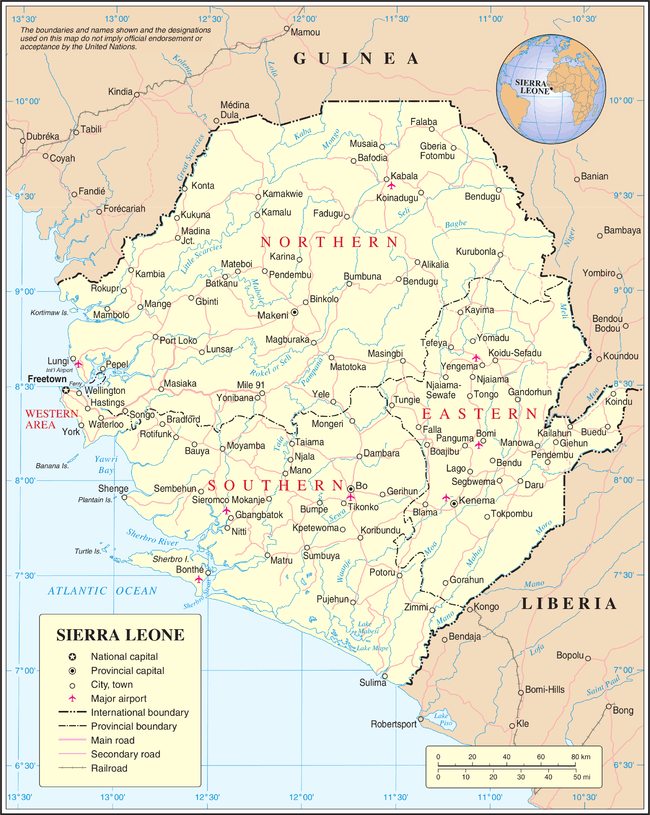
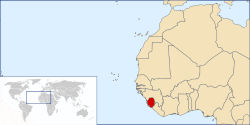
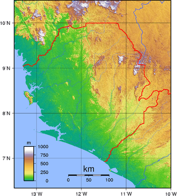
Sierra Leone is located on the west coast of Africa, between the 7th and 10th parallels north of the equator. Sierra Leone is bordered by Guinea to the north and northeast, Liberia to the south and southeast, and the Atlantic Ocean to the west.[1]
Sierra Leone has a total area of 71,740 km2 (27,699 sq mi), divided into a land area of 71,620 km2 (27,653 sq mi) and water of 120 km2 (46 sq mi).[2]
Sierra Leone has four distinct geographical regions: coastal Guinean mangroves, the wooded hill country, an upland plateau, and the eastern mountains. Eastern Sierra Leone is an interior region of large plateaus interspersed with high mountains, where Mount Bintumani rises to 1,948 meters (6,391 ft).[1]
Physical geography
Sierra Leone is located on the west coast of Africa, between the 7th and 10th parallels north of the equator. Sierra Leone is bordered by Guinea to the north and northeast, Liberia to the south and southeast, and the Atlantic Ocean to the west.[1] The country has a total area of 71,740 km2 (27,699 sq mi), divided into a land area of 71,620 km2 (27,653 sq mi) and water of 120 km2 (46 sq mi).[2]
Sierra Leone has four distinct geographical regions: coastal Guinean mangroves, the wooded hill country, an upland plateau, and the eastern mountains. Eastern Sierra Leone is an interior region of large plateaus interspersed with high mountains, where Mount Bintumani rises to 1,948 meters (6,391 ft).[1]
Geology
Sierra Leone can be split into three geological areas, in the east is part of the West African craton, the western area consists of the Rokelides, an orogenic belt, and a 20- to 30-km coastal strip of sediments.[3]
Extreme points
This is a list of the extreme points of Sierra Leone, the points that are farther north, south, east or west than any other location.
- Northernmost point – the northern section of the border with Guinea, Northern Province*
- Easternmost point – the tripoint with Guinea and Liberia, Eastern Province
- Southernmost point – unnamed peninsula south of the town of Mano Salija at the mouth of the Mano River, Southern Province
- Westernmost point - the point at which the border with Guinea enters the Atlantic Ocean, Northern Province
- *Note: Sierra Leone does not have a northernmost point, the border being formed here by 10th parallel north
Climate
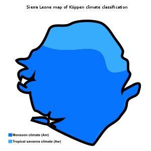
The climate is tropical; although it could be classified as a tropical monsoon climate, it could also be describe as a climate that is transitional between a continually wet tropical rainforest climate and a tropical savanna climate.[4]
There are two seasons; dry season (November - May) and rainy season (June - October).
December to January are the coolest months of the year, although temperatures can still exceed 40°C, lower to moderate humidity makes the heat around this time of the year more torerable. Unlike March and April, the months that it gets uncomfortably hot and humid with tempetures around 38°C - 45°C and a solid 90% humidity, making the heat index higher than the actual temperature. The average sea temperature is 30°C.
C (6)s 27 °C (80.6 °F) 25 °C (77.0 °F) to 29 °C (84.2 °F)ear.[2][5][6]
Average rainfall is highest at the coast, 3000–5000 mm per year; moving inland this decreases and at the eastern border of the country, the average rainfall is 2000-2500mm.[7]
Environment issues
Rapid population growth in Sierra Leone has put pressure upon the natural environment. Environmental problems include the overharvesting of timber, the expansion of cattle grazing and slash and burn agriculture have resulted in deforestation and soil exhaustion, and overfishing.
Sierra Leone is party to several environmental agreements:[2]
- Biodiversity (Convention on Biological Diversity)
- Climate Change (United Nations Framework Convention on Climate Change)
- Desertification (United Nations Convention to Combat Desertification)
- Endangered Species (CITES)
- Law of the Sea(UNCLOS or LOS)
- Marine Life Conservation (Convention on Fishing and Conservation of Living Resources of the High Seas)
- Nuclear Test Ban(CTBT)
- Ramsar Convention(Wetlands)
Signed, but not ratified:
- Environmental Modification(ENMOD)
General information
Geographic coordinates: 8°30′N 11°30′W / 8.500°N 11.500°W
Land boundaries:
total: 1,0938 km
border countries: Guinea 794 km, Liberia 299 km
Coastline: 402 km
Maritime claims:
territorial sea: 200 nmi (370.4 km; 230.2 mi).
contiguous zone: 24 nmi (44.4 km; 27.6 mi).
exclusive economic zone: 200 nmi (370.4 km; 230.2 mi).
continental shelf: 200 m depth or to the depth of exploitation.
Climate: tropical; hot, humid; summer rainy season (May to December); winter dry season (December to April)
Terrain: coastal belt of mangrove swamps, wooded hill country, upland plateau, mountains in east.
Elevation extremes:
lowest point: Atlantic Ocean 0 m
highest point: Loma Mansa (Bintimani) 1,948 m
Natural resources: diamonds, titanium ore, bauxite, iron ore, gold, chromite.
Land use:
arable land: 24.4%
permanent crops: 2.3%
permanent pasture: 30.5%
forest: 37.5%
other: 6.3% (2011)
Irrigated land: 300 km²; (2012)
Total renewable water resources: 160 km3; (2011)
Natural hazards: dry, sand-laden harmattan winds blow from the Sahara (December to February); sandstorms, dust storms.
See also
References
- 1 2 3 4 LeVert, Suzanne (2006). Cultures of the World: Sierra Leone. Marshall Cavendish (published 2007). p. 7. ISBN 978-0-7614-2334-8
- 1 2 3 4 "CIA: The World Factbook: Sierra Leone".
- ↑ Schlüter, Thomas; Martin H. Trauth (2008). Geological atlas of Africa: with notes on stratigraphy, tectonics, economic geology, geohazards, geosites and geoscientific education of each country. Springer. p. 220. ISBN 978-3-540-76324-6.
- ↑ Gabler, Robert E.; James F. Petersen; L. Michael Trapasso; Dorothy Sack (2008). Physical Geography. Cengage Learning. p. 238. ISBN 978-0-495-55506-3.
- ↑ Blinker, Linda (September 2006). "COUNTRY ENVIRONMENT PROFILE (CEP) SIERRA LEONE" (PDF). Freetown, Sierra Leone: CONSORTIUM PARSONS BRINCKERHOFF: 12. Archived from the original (PDF) on 2008-10-01. Retrieved 2008-09-25
- ↑ LeVert, Suzanne (2006). Cultures of the World: Sierra Leone. Marshall Cavendish (published 2007). pp. 8–9. ISBN 978-0-7614-2334-8
- ↑ Hughes, R. H.; J. S. Hughes (1992). A directory of African wetlands. IUCN. p. 435. ISBN 978-2-88032-949-5.