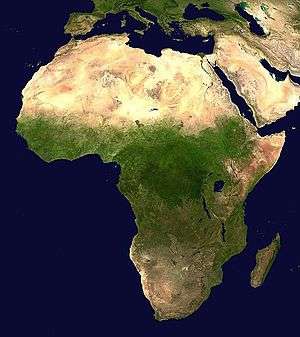
Climate of Africa
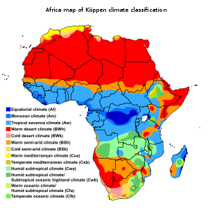
Owing to Africa's position across equatorial and subtropical latitudes in both the northern and southern hemisphere, several different climate types can be found within it. The continent mainly lies within the intertropical zone between the Tropic of Cancer and the Tropic of Capricorn. Hence, it’s interesting density of humidity intensity is always high, and it is a hot continent. Warm and hot climates prevail all over Africa, but the northern part is that most marked by aridity and high temperatures. Only the northernmost and the southernmost fringes of the continent have a Mediterranean climate.The equator runs through the middle of Africa, as do the Tropic of Cancer and the Tropic of Capricorn, making Africa the most tropical continent.
The climate of Africa is a range of climates such as the equatorial climate, the tropical wet and dry climate, the tropical monsoon climate, the semi-desert climate (semi-arid), the desert climate (hyper-arid and arid), the subtropical highland climate etc. Temperate climates are rare across the continent except at very high elevations and along the fringes. In fact, the climate of Africa is more variable by rainfall amount than by temperatures, which are consistently high. African deserts are the sunniest and the driest parts of the continent, owing to the prevailing presence of the subtropical ridge with subsiding, hot, dry air masses. Africa holds many heat-related records: the continent has the hottest extended region year-round, the areas with the hottest summer climate, the highest sunshine duration etc.
Temperatures
Globally, heating of the earth near the equator leads to large amounts of upward motion and convection along the monsoon trough or Intertropical Convergence Zone. The divergence over the near-equatorial trough leads to air rising and moving away from the equator aloft. As it moves towards the Mid-Latitudes, the air cools and sinks, which leads to subsidence near the 30th parallel of both hemispheres. This circulation is known as the Hadley cell and leads to the formation of the subtropical ridge.[1] Many of the world's deserts are caused by these climatological high-pressure areas,[2] including the Sahara Desert.
Temperatures are hottest within the Sahara regions of Algeria and Mali,[3] and coolest across the south and at elevation within the topography across the eastern and northwest sections of the continent. The hottest average temperature on Earth is at Dallol, Ethiopia, which averages a temperature of 33.9 °C (93.0 °F) throughout the year.[4] The hottest temperature recorded within Africa, which was also the world record, was 57.8 °C (136.0 °F) at 'Aziziya, Libya on September 13, 1922. This was later proven to be false, and to derive from an inaccurate reading of a thermometer. The world's hottest place is in fact Death Valley, in California.[5][6][7] Apparent temperatures, combining the effect of the temperature and humidity, along the Red Sea coast of Eritrea and Gulf of Aden coast of Somalia range between 57 °C (135 °F) and 63 °C (145 °F) during the afternoon hours.[3] The lowest temperature measured within Africa was −24 °C (−11 °F) at Ifrane, Morocco on February 11, 1935.[5] Nevertheless, the major part of Africa experiences extreme heat during much of the year, especially the deserts, steppes and savannas. The African deserts are arguably the hottest places on Earth, especially the Sahara Desert and the Danakil Desert, located in the Horn of Africa.
Wind
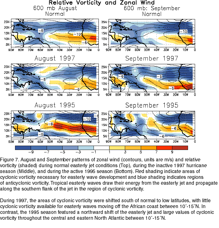
The low-level easterly African jet stream is considered to play a crucial role in the southwest monsoon of Africa,[8] and helps form the tropical waves which march across the tropical Atlantic and eastern Pacific oceans during the warm season.[9] The jet exhibits both barotropic and baroclinic instability, which produces synoptic-scale, westward-propagating disturbances in the jet known as African easterly waves, or tropical waves. A small number of mesoscale storm systems embedded in these waves develop into tropical cyclones after they move from west Africa into the tropical Atlantic, mainly during August and September. When the jet lies south of normal during the peak months of the Atlantic hurricane season, tropical cyclone formation is suppressed.[10]
Precipitation
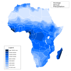
Great parts of North Africa and Southern Africa as well as the whole Horn of Africa mainly have a hot desert climate, or a hot semi-arid climate for the wetter locations. The Sahara Desert in North Africa is the largest hot desert in the world and is one of the hottest, driest and sunniest places on Earth. Located just south of the Sahara is a narrow steppe (a semi-arid region) called the Sahel, while Africa's most southern areas contain both savanna plains, and its central portion contains very dense jungle (rainforest) regions. The equatorial region near the Intertropical Convergence Zone is the wettest portion of the continent. Annually, the rain belt across the country moves northward into Sub-Saharan Africa by August, then passes back southward into south-central Africa by March.[11] Areas with a savannah climate in Sub-Saharan Africa, such as Ghana, Burkina Faso,[12][13] Darfur,[14] Eritrea,[15] Ethiopia,[16] and Botswana have a distinct rainy season.[17] El Nino results in drier-than-normal conditions in Southern Africa from December to February, and wetter-than-normal conditions in equatorial East Africa over the same period.[18]
In Madagascar, trade winds bring moisture up the eastern slopes of the island, which is deposited as rainfall, and bring drier downsloped winds to areas south and west, leaving the western sections of the island in a rain shadow. This leads to significantly more rainfall over northeast sections of Madagascar than its southwestern portions.[19] Southern Africa receives most of its rainfall from summer convective storms and with extratropical cyclones moving through the Westerlies. Once a decade, tropical cyclones lead to excessive rainfall across the region.[20]
Snow and glaciers
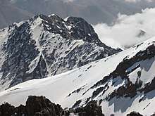
Snow is an almost annual occurrence on some of the mountains of South Africa, including those of the Cedarberg and around Ceres in the South-Western Cape, and on the Drakensberg in Natal and Lesotho. Tiffendell Resort in the Drakensberg is the only commercial skiing that takes place in South Africa, and has "advanced snow-making capability" allowing skiing for three months of the year.[21] The Mountain Club of South Africa (MCSA) and the Mountain and Ski Club (MSC) [22] of the University of Cape Town both have equipped ski huts in the Hex River mountains. Skiing including snowboarding in the Cape is a hit-and-miss affair, both in terms of timing of snowfalls, and whether there is sufficient snow to cover the rocks.
Table Mountain gets a light dusting of snow on the Front Table and also at Devil's Peak every few years. Snowfalls on Table Mountain took place on 20 September 2013;[23] 30 Aug 2013;[24] 5 August 2011;[25] and on 15 June 2010.[26]
Snow is a rare occurrence in Johannesburg; it fell in May 1956, August 1962, June 1964, September 1981, August 2006, and on 27 June 2007,[27] accumulating up to 10 centimetres (3.9 in) in the southern suburbs.
Additionally, snow regularly falls in the Atlas Mountains in the Maghreb. Snowfall is also a regular occurrence at Mount Kilimanjaro in Tanzania.
There have been permanent glaciers on the Rwenzori Mountains, on the border of Uganda and the Democratic Republic of the Congo. However, by the 2010s, the glaciers were in retreat, and they are under threat of disappearing through rising temperatures.[28]
See also
References
- ↑ Dr. Owen E. Thompson (1996). Hadley Circulation Cell. Archived 2009-03-05 at the Wayback Machine. Channel Video Productions. Retrieved on 2007-02-11.
- ↑ ThinkQuest team 26634 (1999). The Formation of Deserts. Archived 2012-10-17 at the Wayback Machine. Oracle ThinkQuest Education Foundation. Retrieved on 2009-02-16.
- 1 2 Christopher C. Burt (2004). Extreme Weather: a guide & record book. W. W. Norton & Company, Inc. pp. 24–28. ISBN 0-393-32658-6.
- ↑ Ronald L. Wagner; Bill Adler, Jr. (1997). The Weather Sourcebook. Adler & Robin Books, Inc. p. 91. ISBN 0-76270-080-7.
- 1 2 Global Measured Extremes of Temperature and Precipitation. National Climatic Data Center. Retrieved on 2007-06-21.
- ↑ El Fadli, KI; et al. (September 2012). "World Meteorological Organization Assessment of the Purported World Record 58°C Temperature Extreme at El Azizia, Libya (13 September 1922)". Bulletin of the American Meteorological Society. 94 (2): 199. Bibcode:2013BAMS...94..199E. doi:10.1175/BAMS-D-12-00093.1. (The 136 °F (57.8 °C), claimed by 'Aziziya, Libya, on September 13, 1922, has been officially deemed invalid by the World Meteorological Organization.)
- ↑ "World Meteorological Organization World Weather / Climate Extremes Archive". Archived from the original on 4 January 2013. Retrieved 10 January 2013.
- ↑ Kerry H. Cook. Generation of the African Easterly Jet and Its Role in Determining West African Precipitation. Retrieved on 2008-05-08.
- ↑ Chris Landsea. AOML Frequently Asked Questions. Subject: A4) What is an easterly wave ? Retrieved on 2008-05-08.
- ↑ Climate Prediction Center (November 1997). "Figure 7". National Oceanic and Atmospheric Administration. Retrieved 2011-02-05.
- ↑ Todd Mitchell (October 2001). "Africa Rainfall Climatology". University of Washington. Retrieved 2010-01-02.
- ↑ Patrick Laux et al. (2008): Predicting the regional onset of the rainy season in West Africa. International Journal of Climatology, 28 (3), 329-342.
- ↑ Patrick Laux et al. (2009): Modelling daily precipitation features in the Volta Basin of West Africa. International Journal of Climatology, 29 (7), 937-954.,
- ↑ David Vandervort (2009). Darfur: getting ready for the rainy season. International Committee of the Red Cross. Retrieved on 2009-02-06.
- ↑ Mehari Tesfazgi Mebrhatu, M. Tsubo, and Sue Walker (2004). A Statistical Model for Seasonal Rainfall Forecasting over the Highlands of Eritrea. New directions for a diverse planet: Proceedings of the 4th International Crop Science Congress. Retrieved on 2009-02-08.
- ↑ Alex Wynter (2009). Ethiopia: March rainy season "critical" for southern pastoralists. Thomson Reuters Foundation. Retrieved on 2009-02-06.
- ↑ The Voice (2009). Botswana: Rainy Season Fills Up Dams. allAfrica.com. Retrieved on 2009-02-06.
- ↑ http://www.scoop.co.nz/stories/WO1010/S00173/la-nina-weather-likely-to-last-for-months.htm
- ↑ T. Andry Arivelo; Professeur A. Ratiarison; Professeur M.Bessafi; Rodolphe Ramiharijafy (2007-12-19). "Madagascar rainfall climatology: Extreme Phenomena" (PDF). Stanford University. Retrieved 2010-01-02.
- ↑ Pearl Mngadi; Petrus JM Visser; Elizabeth Ebert (October 2006). "Southern Africa Satellite Derived Rainfall Estimates Validation" (PDF). International Precipitation Working Group. p. 1. Retrieved 2010-01-05.
- ↑ "Skiing and Snowboarding". Tiffendell. Retrieved 16 February 2014.
- ↑ "UCT Mountain and Ski Club". Retrieved 16 February 2014.
- ↑ "Snow on Table Mountain". Retrieved 16 February 2014.
- ↑ "Snow Doubt…There's Snow on Table Mountain Today". Retrieved 16 February 2014.
- ↑ "Snow on Table Mountain: August Chill Sets In". Retrieved 16 February 2014.
- ↑ "Icy Weather Brings Snow to Table Mountain". Retrieved 16 February 2014.
- ↑ SABCnews.com. "Joburg covered by snow as temperature drops". Archived from the original on 2007-06-29. Retrieved 2007-07-16.
- ↑ Dalsy Carrington, CNN, April,3, 2014 "Last chance to see: Disappearing glaciers in the 'Mountains of the Moon'" http://www.cnn.com/2014/04/03/world/africa/last-chance-disappearing-glaciers/