Geography of South Sudan
| Continent | Africa |
|---|---|
| Coordinates | 05°N 31°E / 5°N 31°E |
| Area | Ranked 45th |
| • Total | 619,745 km2 (239,285 sq mi) |
| Borders |
|
| Highest point |
Kinyeti 3,187 m (10,456.0 ft) |
| Longest river | White Nile |
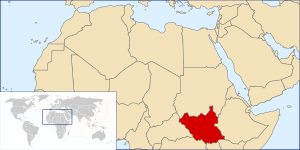
The geography of South Sudan describes the physical features of South Sudan, a country in East Africa. South Sudan is a landlocked country and borders - clockwise - Sudan from the north, Ethiopia from the east, Kenya, Uganda and the Democratic Republic of the Congo from the south and the Central African Republic from the west.
Until July 9, 2011 it was part of Sudan, then the largest country in Africa before a referendum took place in January 2011.[1]
Political Geography
South Sudan is divided into 32 states which correspond to three historical regions of the Sudan: Bahr el Ghazal, Equatoria, and Greater Upper Nile.
Bahr el Ghazal
- Aweil
- Aweil East
- Eastern Lakes
- Gogrial
- Gok
- Lol
- Tonj
- Twic
- Wau
- RUMBEK
Equatoria
Greater Upper Nile
- Boma
- Eastern Bieh
- Eastern Nile
- Jonglei
- Latjoor
- Northern Liech
- Ruweng
- Southern Liech
- Fangak (earlier called Western Bieh)
- Western Nile
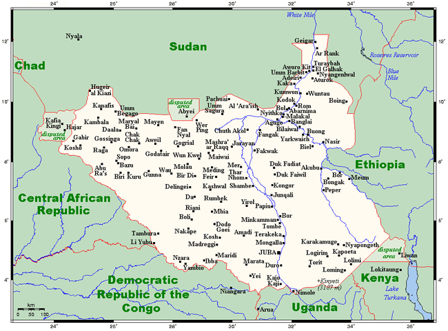
Disputed areas
- Abyei Area, a small region of Sudan bordering on the South Sudanese states of Northern Bahr el Ghazal, Warrap, and Unity, currently has a special administrative status in Sudan and is governed by an Abyei Area Administration. It was due to hold a referendum in 2011 on whether to join South Sudan or remain part of the Republic of Sudan, but in May the North Sudanese military seized Abyei, and it is not clear if the referendum will be held.
- Kafia Kingi, the westernmost part of South Sudan, which according to the Comprehensive Peace Agreement should have been given to South Sudan by Sudan. However, that did not happen, although South Sudanese troops were present there for several times. The area of Kafia Kingi, because it is disputed, so remote and far off, appears to be a safe haven for smugglers and criminals like the former head of the Lord Resistance Army, Joseph Kony. Most of Kafia Kingi is within Radom National Park, a Sudanese biosphere reserve, which is not far larger than Kafia Kingi itself.
- Ilemi Triangle, a small region of South Sudan in the far southeast bordering Kenya and Ethiopia and formerly disputed between Sudan and Kenya. With the South Sudanese independence from Sudan, South Sudan also took over the dispute around the Ilemi triangle. The triangle is now almost entirely considered Kenyan by Kenya – and it is a de facto control area of Kenya. The position of the South Sudanese government on the triangle is not clear.
Land boundaries
The length of South Sudan's borders is 4,797 kilometers.
Bordering countries are (with boundary length):
- Central African Republic (682 km)
- Democratic Republic of the Congo (628 km)
- Ethiopia (883 km)
- Kenya (232 km)
- Sudan (1,937 km)
- Uganda (435 km)
Topography
Mountains
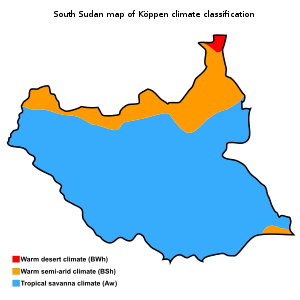
The Imatong Mountains are located in the southeast of South Sudan in the erstwhile state of Eastern Equatoria, and extend into Uganda. Mount Kinyeti is the highest mountain of the range at 3,187 metres (10,456 ft), and the highest in the whole of South Sudan. The range has an equatorial climate and had dense montane forests supporting diverse wildlife. In recent years the rich ecology has been severely degraded by forest clearance and subsistence farming, leading to extensive erosion of the steep slopes.
Natural resources
South Sudan is mostly covered in tropical forest, swamps, and grassland. The White Nile passes through the country, passing by the capital city of Juba.[2]
Half the water of the White Nile is lost in the swamps as vegetation absorbs it or animals drink it. The Sudd, the Bahr el Ghazal and the Sobat River swamps provide a significant resource for wild animals, as well as livestock.
See also
- Index:—Geography of South Sudan
References
| Wikimedia Commons has media related to Geography of South Sudan. |
- ↑ "First day of south Sudan referendum ends peacefully". Tehran Times. 10 January 2011. Retrieved 10 January 2011.
- ↑ Moukaddem, Karimeh (6 June 2011). "South Sudan's tropical forests fast disappearing". Sudan.net. Archived from the original on 28 September 2011. Retrieved 9 July 2011.