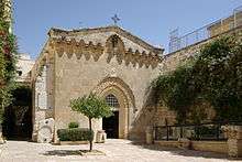
Church of the Flagellation
| Church of the Flagellation | |
|---|---|
 | |
| Basic information | |
| Location | Jerusalem |
| Affiliation | Roman Catholic |
| Architectural description | |
| Architect(s) | Antonio Barluzzi |
| Completed | 1929 |
The Church of the Flagellation is a Roman Catholic church and Christian pilgrimage site located in the Muslim Quarter of the Old City of Jerusalem, near St. Stephen's, or Lions, Gate. It is part of the Franciscan Monastery of the Flagellation, which also includes the Church of the Condemnation and Imposition of the Cross. The monastery stands at the traditional Second Station of the Cross on Via Dolorosa.
Tradition
According to tradition, the church enshrines the spot where Jesus Christ was flogged by Roman soldiers before his journey down the Via Dolorosa to Calvary. However, this tradition is based on the mistaken assumption that an area of Roman flagstones, discovered beneath the adjacent Church of the Condemnation and Imposition of the Cross and the Convent of the Sisters of Zion, was the pavement (Greek: lithostrotos, Aramaic: gabbatha) which the Bible describes as the location of Pontius Pilate's judgment of Jesus (John 19:13); archaeological investigation now indicates that these slabs are the paving of the eastern of two 2nd-century forums, built by Hadrian as part of the construction of Aelia Capitolina.[1] The site of the eastern forum had previously been a large open-air pool, the Struthion Pool, which was built by the Hasmoneans, mentioned by Josephus as being adjacent to the Antonia Fortress in the first century,[2] and is still present beneath Hadrian's flagstones.
Like Philo, Josephus testifies that the Roman governors stayed in Herod's palace while they were in Jerusalem,[1] carried out their judgements on the pavement immediately outside it, and had those found guilty flogged there;[3] Josephus indicates that Herod's palace is on the western hill,[4] and it has recently (2001) been rediscovered under a corner of the Jerusalem citadel near Jaffa Gate. Archaeologists now therefore conclude that, in the first century, the Roman governors judged at the western hill, rather than the area around the Church of the Flagellation, on the diametrically opposite side of the city.[1]
History
The original church was built by the Crusaders.[5][6] During the Ottoman period (which in Palestine started in 1516), this early shrine and its surrounding buildings were reportedly used as stables, and later as private houses.
The whole complex was given to the Franciscans in 1838 by Ibrahim Pasha of Egypt,[5][6] who brought parts of Ottoman Syria under Egyptian rule between 1831-41. In 1839 Duke Maximilian Joseph in Bavaria funded a hasty rebuilding of the church over the medieval ruins.[5][6]
The current church was completed between 1928-29 and was a complete reconstruction, executed by Italian Antonio Barluzzi in the style of the 12th century.[5][6] The church is held in trust by the Franciscan Custody of the Holy Land.
Description
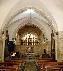
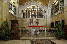
The interior of the church consists of a single aisle.
Some noteworthy points of interest include the three stained glass windows, each depicting a different aspect of the biblical narrative of the trial of Jesus by Pilate, and the inside of the mosaic-clad golden dome. The northern window depicts Pontius Pilate washing his hands (Matthew 27:24), the central one behind the altar depicts the Flagellation ({Mark 15:15, John 19:1), and the southern one the victory of Barabbas (Matthew 27:26, Mark 15:15, Luke 23:24–25). The dome with its mosaic and translucent elements is designed as a crown of thorns.
References
- 1 2 3 Pierre Benoit, The Archaeological Reconstruction of the Antonia Fortress, in Jerusalem Revealed (edited by Yigael Yadin), page 87, (1976)
- ↑ Josephus, Jewish War 5:11:4
- ↑ Josephus, Jewish Wars, 2:14:8
- ↑ Josephus, Jewish Wars, 5:2
- 1 2 3 4 Erhard Gorys (1996). Heiliges Land. Kunst-Reiseführer (in German). Cologne: DuMont. p. 93. ISBN 3-7701-3860-0. Retrieved 1 March 2018.
- 1 2 3 4 ArxNet, The Chapel of the Flagellation, Via Dolorosa
External links
| Wikimedia Commons has media related to Church of the Flagellation. |
Coordinates: 31°46′49.93″N 35°14′03.72″E / 31.7805361°N 35.2343667°E