Chestnut Mountain (Caldwell County, North Carolina)
| Chestnut Mountain | |
|---|---|
 Chestnut Mountain | |
| Highest point | |
| Elevation | 3,314 ft (1,010 m) |
| Coordinates | 35°57′42″N 81°48′25″W / 35.96167°N 81.80694°W |
| Geography | |
| Location | Avery / Burke / Caldwell counties, North Carolina, U.S. |
| Parent range | Blue Ridge Mountains |
| Topo map | USGS Chestnut Mountain |
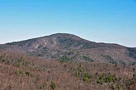
Chestnut Mountain[1] is a mountain in the North Carolina High Country and wholly in the Pisgah National Forest. Its elevation reaches 3,314 feet (1,010 m) and it also marks the corner between Avery, Burke, and Caldwell counties. The mountain generates feeder streams for the Catawba River.
References
This article is issued from
Wikipedia.
The text is licensed under Creative Commons - Attribution - Sharealike.
Additional terms may apply for the media files.