Chaussy, Val-d'Oise
| Chaussy | |
|---|---|
| Commune | |
.JPG) A general view of Chaussy | |
 Chaussy Location within Île-de-France region  Chaussy | |
| Coordinates: 49°07′21″N 1°41′33″E / 49.1225°N 1.6925°ECoordinates: 49°07′21″N 1°41′33″E / 49.1225°N 1.6925°E | |
| Country | France |
| Region | Île-de-France |
| Department | Val-d'Oise |
| Arrondissement | Pontoise |
| Canton | Vauréal |
| Intercommunality | Vexin Val de Seine |
| Government | |
| • Mayor (2001–2008) | Georges Bigot |
| Area1 | 14.56 km2 (5.62 sq mi) |
| Population (2015)2 | 599 |
| • Density | 41/km2 (110/sq mi) |
| Time zone | UTC+1 (CET) |
| • Summer (DST) | UTC+2 (CEST) |
| INSEE/Postal code | 95150 /95710 |
| Elevation | 45–202 m (148–663 ft) |
|
1 French Land Register data, which excludes lakes, ponds, glaciers > 1 km2 (0.386 sq mi or 247 acres) and river estuaries. 2 Population without double counting: residents of multiple communes (e.g., students and military personnel) only counted once. | |
Chaussy is a commune in the Val-d'Oise department in Île-de-France in northern France. It is located in the reigonal national park of Vexin.
Geography
Chaussy is located approximately 55km from the center of Paris.
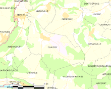
A map of the commune
Gallery
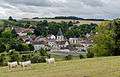 A view of Chaussy
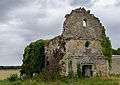 The ruins of Chapelle Saint-Laurent de Méré
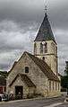 The church of Chaussy
%2C_ch%C3%A2teau_du_Prieur%C3%A9_(golf_de_Villarceaux)_2.JPG) The château du Prieuré
The château du Prieuré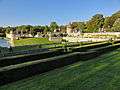
See also
References
- INSEE
- Association of Mayors of the Val d’Oise (in French)
External links
| Wikimedia Commons has media related to Chaussy (Val-d'Oise). |
- Official website (in French)
- Mérimée database - Cultural heritage (in French)
- Land use (IAURIF) (in English)
This article is issued from
Wikipedia.
The text is licensed under Creative Commons - Attribution - Sharealike.
Additional terms may apply for the media files.