Charyshsky District
| Charyshsky District Чарышский район (Russian) | |
|---|---|
.svg.png) Location of Charyshsky District in Altai Krai | |
| Coordinates: 51°24′N 83°34′E / 51.400°N 83.567°ECoordinates: 51°24′N 83°34′E / 51.400°N 83.567°E | |
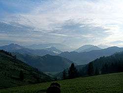 Bashchelaksky Ridge on the territory of Charyshsky District | |
| Location | |
| Country | Russia |
| Federal subject | Altai Krai[1] |
| Administrative structure (as of October 2012) | |
| Administrative center | selo of Charyshskoye[1] |
| Administrative divisions:[1] | |
| selsoviet | 9 |
| Inhabited localities:[1] | |
| Rural localities | 32 |
| Municipal structure (as of July 2012) | |
| Municipally incorporated as | Charyshsky Municipal District[2] |
| Municipal divisions:[2] | |
| Urban settlements | 0 |
| Rural settlements | 9 |
| Statistics | |
| Area | 6,881 km2 (2,657 sq mi)[3] |
| Population (2010 Census) | 12,337 inhabitants[4] |
| • Urban | 0% |
| • Rural | 100% |
| Density | 1.79/km2 (4.6/sq mi)[5] |
| Time zone | KRAT (UTC+07:00)[6] |
| Official website | |
| Charyshsky District on WikiCommons | |
Charyshsky District (Russian: Чары́шский райо́н) is an administrative[1] and municipal[2] district (raion), one of the fifty-nine in Altai Krai, Russia. It is located in the south of the krai. The area of the district is 6,881 square kilometers (2,657 sq mi).[3] Its administrative center is the rural locality (a selo) of Charyshskoye.[1] Population: 12,337 (2010 Census);[4] 14,898 (2002 Census);[7] 15,774 (1989 Census).[8] The population of Charyshskoye accounts for 26.1% of the district's total population.[4]
Geography
Charyshsky District is located in the southeast of Altai Krai, on the western foothills and beginnings of the Altai Mountains to the east. The Charysh River flows from east to west across the central part of the district. The area in the northwest of the district is low foothills, and the administrative center, the town of Charyshsky, is in the northwest on the Charysh River banks. Most of the southeast is forested and mountainous, on black (chernozem) southern mountain soils. Charyshsky District is 175 km west of the city of Barnaul, and 3,000 km east of Moscow. The area measures 130 km (north-south), and 80 km (west-east); total area is 6,910 km2 (about 7% of Altai Krai).[3]
The district is bordered on the north by Ust-Kalmansky District, on the east by the Altai Republic, on the south by Kazakhstan, and on the west by Krasnoshchyokovsky District.
History
Charyshsky District was formed as part of the Biysk Altai district on May 27, 1924. It was renamed Charyshsky District on January 1, 1932. In 1963 it was included into Ust-Kalmansky District, but restored as a separate district (renamed Charyshsky District) later in 1963.
References
Notes
- 1 2 3 4 5 6 Law #28-ZS
- 1 2 3 Law #8-ZS
- 1 2 3 "General Information" (in Russian). Charyshsky District. Retrieved August 31, 2016.
- 1 2 3 Russian Federal State Statistics Service (2011). "Всероссийская перепись населения 2010 года. Том 1" [2010 All-Russian Population Census, vol. 1]. Всероссийская перепись населения 2010 года (2010 All-Russia Population Census) (in Russian). Federal State Statistics Service. Retrieved June 29, 2012.
- ↑ The value of density was calculated automatically by dividing the 2010 Census population by the area specified in the infobox. Please note that this value is only approximate as the area specified in the infobox does not necessarily correspond to the area of the entity proper or is reported for the same year as the population.
- ↑ Правительство Российской Федерации. Федеральный закон №107-ФЗ от 3 июня 2011 г. «Об исчислении времени», в ред. Федерального закона №271-ФЗ от 03 июля 2016 г. «О внесении изменений в Федеральный закон "Об исчислении времени"». Вступил в силу по истечении шестидесяти дней после дня официального опубликования (6 августа 2011 г.). Опубликован: "Российская газета", №120, 6 июня 2011 г. (Government of the Russian Federation. Federal Law #107-FZ of June 31, 2011 On Calculating Time, as amended by the Federal Law #271-FZ of July 03, 2016 On Amending Federal Law "On Calculating Time". Effective as of after sixty days following the day of the official publication.).
- ↑ Russian Federal State Statistics Service (May 21, 2004). "Численность населения России, субъектов Российской Федерации в составе федеральных округов, районов, городских поселений, сельских населённых пунктов – районных центров и сельских населённых пунктов с населением 3 тысячи и более человек" [Population of Russia, Its Federal Districts, Federal Subjects, Districts, Urban Localities, Rural Localities—Administrative Centers, and Rural Localities with Population of Over 3,000] (XLS). Всероссийская перепись населения 2002 года [All-Russia Population Census of 2002] (in Russian). Retrieved August 9, 2014.
- ↑ Demoscope Weekly (1989). "Всесоюзная перепись населения 1989 г. Численность наличного населения союзных и автономных республик, автономных областей и округов, краёв, областей, районов, городских поселений и сёл-райцентров" [All Union Population Census of 1989: Present Population of Union and Autonomous Republics, Autonomous Oblasts and Okrugs, Krais, Oblasts, Districts, Urban Settlements, and Villages Serving as District Administrative Centers]. Всесоюзная перепись населения 1989 года [All-Union Population Census of 1989] (in Russian). Институт демографии Национального исследовательского университета: Высшая школа экономики [Institute of Demography at the National Research University: Higher School of Economics]. Retrieved August 9, 2014.
Sources
- Алтайский краевой Совет народных депутатов. Закон №28-ЗС от 1 марта 2008 г. «Об административно-территориальном устройстве Алтайского края», в ред. Закона №16-ЗС от 4 апреля 2017 г. «О присоединении станции Железнодорожная Казарма 572 км к посёлку Октябрьскому Октябрьского сельсовета Кулундинского района Алтайского края и внесении изменений в отдельные законы Алтайского края». Вступил в силу 8 марта 2008 г. Опубликован: "Алтайская правда", №67, 8 марта 2008 г. (Altai Krai Council of People's Deputies. Law #28-ZS of March 1, 2008 On the Administrative-Territorial Structure of Altai Krai, as amended by the Law #16-ZS of April 4, 2017 On Merging the Station of Zheleznodorozhnaya Kazarma 572 km into the Settlement of Oktyabrsky in Oktyabrsky Selsoviet of Kulundinsky District of Altai Krai and on Amending Various Laws of Altai Krai. Effective as of March 8, 2008.).
- Алтайский краевой Совет народных депутатов. Закон №8-ЗС от 1 февраля 2007 г. «О статусе и границах муниципальных и административно-территориальных образований Чарышского района Алтайского края», в ред. Закона №55-ЗС от 5 июля 2012 г. «О внесении изменений в отдельные Законы Алтайского края в связи с преобразованием муниципальных и административно-территориальных образований». Вступил в силу через 10 дней со дня официального опубликования. Опубликован: "Алтайская правда", №48 (без приложений), 17 февраля 2007 г. (Altai Krai Council of People's Deputies. Law #8-ZS of February 1, 2007 On the Status and the Borders of the Municipal and the Administrative-Territorial Formations of Charyshsky District of Altai Krai, as amended by the Law #55-ZS of July 5, 2012 On Amending Various Laws of Altai Krai Due to the Transformation of the Municipal and Administrative-Territorial Formations. Effective as of after 10 days from the day of the official publication.).