Blagoveshchensky District, Altai Krai
| Blagoveshchensky District Благовещенский район (Russian) | |
|---|---|
.svg.png) Location of Blagoveshchensky District in Altai Krai | |
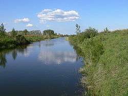 Kulundinsky Irrigation Canal near the selo of Glyaden in Blagoveshchensky District | |
| Location | |
| Country | Russia |
| Federal subject | Altai Krai[1] |
| Administrative structure (as of October 2012) | |
| Administrative center | work settlement of Blagoveshchenka[1] |
| Administrative divisions:[1] | |
| Settlement administrations | 2 |
| Selsoviets | 10 |
| Inhabited localities:[1] | |
| Urban-type settlements[2] | 2 |
| Rural localities | 28 |
| Municipal structure (as of July 2012) | |
| Municipally incorporated as | Blagoveshchensky Municipal District[3] |
| Municipal divisions:[3] | |
| Urban settlements | 2 |
| Rural settlements | 10 |
| Statistics | |
| Area | 3,700 km2 (1,400 sq mi)[4] |
| Population (2010 Census) | 30,783 inhabitants[5] |
| • Urban | 59.4% |
| • Rural | 40.6% |
| Density | 8.32/km2 (21.5/sq mi)[6] |
| Time zone | KRAT (UTC+07:00)[7] |
| Official website | |
| Blagoveshchensky District on WikiCommons | |
Blagoveshchensky District (Russian: Благове́щенский райо́н) is an administrative[1] and municipal[3] district (raion), one of the fifty-nine in Altai Krai, Russia. It is located in the west of the krai. The area of the district is 3,700 square kilometers (1,400 sq mi).[4] Its administrative center is the urban locality (a work settlement) of Blagoveshchenka.[1] Population: 30,783 (2010 Census);[5] 34,878 (2002 Census);[8] 44,849 (1989 Census).[9] The population of Blagoveshchenka accounts for 37.8% of the district's total population.[5]
Geography
Blagoveshchensky District is located in the northwest of Altai Krai, on flat terrain of the Kulundra Steppe of the West Siberian Plain. Much of the western border of the district is the shore of Lake Kulundinskoye. There are over 20 bitter-salty and freshwater lakes in the district. Lake Kuchukskogo, the second largest lake, has mineral salts and medicinal muds. The Kulunda River flows in a wide, waterlogged plain from east to west across the north of the district, before emptying into Lake Kulundinskoye. The soils are brown soils and southern black soils, with large deposits of clay, gravel, and sand. Agriculture is supported on rectangular plots, covering 68.3% of the district.[4]
Blagoveshchensky District is 210 km west of the regional city of Barnaul, and 2,650 km east of Moscow. The area measures 55 km (north-south), and 85 km (west-east); total area is 3,700 km2 (about 2% of Altai Krai). The administrative center is the town of Blagoveshchenka.[4]
The district is bordered on the north by Suyetsky District, on the northeast by Bayevsky District, on the east by Zavyalovsky District, on the south by Rodinsky District, and on the west by Kulundinsky District.
References
Notes
- 1 2 3 4 5 6 Law #28-ZS
- ↑ The count of urban-type settlements may include the work settlements, the resort settlements, the suburban (dacha) settlements, as well as urban-type settlements proper.
- 1 2 3 Law #16-ZS
- 1 2 3 4 "General Information". Official District Website. Blagoveshchensky District. Retrieved 31 August 2016.
- 1 2 3 Russian Federal State Statistics Service (2011). "Всероссийская перепись населения 2010 года. Том 1" [2010 All-Russian Population Census, vol. 1]. Всероссийская перепись населения 2010 года (2010 All-Russia Population Census) (in Russian). Federal State Statistics Service. Retrieved June 29, 2012.
- ↑ The value of density was calculated automatically by dividing the 2010 Census population by the area specified in the infobox. Please note that this value is only approximate as the area specified in the infobox does not necessarily correspond to the area of the entity proper or is reported for the same year as the population.
- ↑ Правительство Российской Федерации. Федеральный закон №107-ФЗ от 3 июня 2011 г. «Об исчислении времени», в ред. Федерального закона №271-ФЗ от 03 июля 2016 г. «О внесении изменений в Федеральный закон "Об исчислении времени"». Вступил в силу по истечении шестидесяти дней после дня официального опубликования (6 августа 2011 г.). Опубликован: "Российская газета", №120, 6 июня 2011 г. (Government of the Russian Federation. Federal Law #107-FZ of June 31, 2011 On Calculating Time, as amended by the Federal Law #271-FZ of July 03, 2016 On Amending Federal Law "On Calculating Time". Effective as of after sixty days following the day of the official publication.).
- ↑ Russian Federal State Statistics Service (May 21, 2004). "Численность населения России, субъектов Российской Федерации в составе федеральных округов, районов, городских поселений, сельских населённых пунктов – районных центров и сельских населённых пунктов с населением 3 тысячи и более человек" [Population of Russia, Its Federal Districts, Federal Subjects, Districts, Urban Localities, Rural Localities—Administrative Centers, and Rural Localities with Population of Over 3,000] (XLS). Всероссийская перепись населения 2002 года [All-Russia Population Census of 2002] (in Russian). Retrieved August 9, 2014.
- ↑ Demoscope Weekly (1989). "Всесоюзная перепись населения 1989 г. Численность наличного населения союзных и автономных республик, автономных областей и округов, краёв, областей, районов, городских поселений и сёл-райцентров" [All Union Population Census of 1989: Present Population of Union and Autonomous Republics, Autonomous Oblasts and Okrugs, Krais, Oblasts, Districts, Urban Settlements, and Villages Serving as District Administrative Centers]. Всесоюзная перепись населения 1989 года [All-Union Population Census of 1989] (in Russian). Институт демографии Национального исследовательского университета: Высшая школа экономики [Institute of Demography at the National Research University: Higher School of Economics]. Retrieved August 9, 2014.
Sources
- Алтайский краевой Совет народных депутатов. Закон №28-ЗС от 1 марта 2008 г. «Об административно-территориальном устройстве Алтайского края», в ред. Закона №16-ЗС от 4 апреля 2017 г. «О присоединении станции Железнодорожная Казарма 572 км к посёлку Октябрьскому Октябрьского сельсовета Кулундинского района Алтайского края и внесении изменений в отдельные законы Алтайского края». Вступил в силу 8 марта 2008 г. Опубликован: "Алтайская правда", №67, 8 марта 2008 г. (Altai Krai Council of People's Deputies. Law #28-ZS of March 1, 2008 On the Administrative-Territorial Structure of Altai Krai, as amended by the Law #16-ZS of April 4, 2017 On Merging the Station of Zheleznodorozhnaya Kazarma 572 km into the Settlement of Oktyabrsky in Oktyabrsky Selsoviet of Kulundinsky District of Altai Krai and on Amending Various Laws of Altai Krai. Effective as of March 8, 2008.).
- Алтайский краевой Совет народных депутатов. Закон №16-ЗС от 7 марта 2006 г. «О статусе и границах муниципальных и административно-территориальных образований Благовещенского района Алтайского края», в ред. Закона №80-ЗС от 29 ноября 2016 г. «О внесении изменений в отдельные Законы Алтайского края в связи с преобразованием муниципальных и административно-территориальных образований». Опубликован: "Алтайская правда", №68 (без приложений), 15 марта 2006 г. (Altai Krai Council of People's Deputies. Law #16-ZS of March 7, 2006 On the Status and the Borders of the Municipal and the Administrative-Territorial Formations of Blagoveshchensky District of Altai Krai, as amended by the Law #80-ZS of November 29, 2016 On Amending Several Laws of Altai Krai Due to the Transformation of Several Municipal and Administrative-Territorial Formations. ).