Altaysky District, Altai Krai
| Altaysky District Алтайский район (Russian) | |
|---|---|
.svg.png) Location of Altaysky District in Altai Krai | |
| Coordinates: 51°56′N 85°19′E / 51.933°N 85.317°ECoordinates: 51°56′N 85°19′E / 51.933°N 85.317°E | |
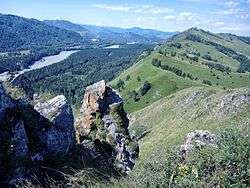 Devil Mountain, Aya Reserve, Altaysky District | |
| Location | |
| Country | Russia |
| Federal subject | Altai Krai[1] |
| Administrative structure (as of October 2012) | |
| Administrative center | selo of Altayskoye[1] |
| Administrative divisions:[1] | |
| selsoviet | 10 |
| Inhabited localities:[1] | |
| Rural localities | 25 |
| Municipal structure (as of July 2012) | |
| Municipally incorporated as | Altaysky Municipal District[2] |
| Municipal divisions:[2] | |
| Urban settlements | 0 |
| Rural settlements | 10 |
| Statistics | |
| Area | 3,490 km2 (1,350 sq mi)[3] |
| Population (2010 Census) | 25,645 inhabitants[4] |
| • Urban | 0% |
| • Rural | 100% |
| Density | 7.35/km2 (19.0/sq mi)[5] |
| Time zone | KRAT (UTC+07:00)[6] |
| Official website | |
| Altaysky District on WikiCommons | |
Altaysky District (Russian: Алта́йский райо́н) is an administrative[1] and municipal[2] district (raion), one of the fifty-nine in Altai Krai, Russia. It is located in the southeast of the krai. The area of the district is 3,400 square kilometers (1,300 sq mi).[3] Its administrative center is the rural locality (a selo) of Altayskoye.[1] Population: 25,645 (2010 Census);[4] 26,984 (2002 Census);[7] 26,287 (1989 Census).[8] The population of Altayskoye accounts for 53.5% of the district's total population.[4]
Geography
Altaysky District is located in the southeast of Altay Krai, on the border with the Altai Republic. The area is on the transitional piedmont between the forest steppe of the West Siberian Plain to the west and the Altai Mountains to the southeast. The Katun River runs south to north along the eastern border of the district, about 100 km upstream from where the Katun meets the Ob River. Altaysky District is 150 km southeast of the regional city of Barnaul, and 3,050 km east of Moscow. The area measures 75 km (north-south), and 75 km (west-east); total area is 3,490 km2 (about 2% of Altai Krai). The administrative center is the town of Altayskoye in the north-center of the district.[3]
The district is bordered on the northwest by Smolensky District, Altai Krai, on the northeast by Sovetsky District, Altai Krai, on the east by Mayminsky District of Altai Republic, and on the southwest by Soloneshensky District.
History
The first small settlement of Russians occurred with the founding of Lower Kayancha founded in 1796. The other main villages were settled shortly thereafter in 1802-1806.[3] In the early 1900's, the royal court advanced funds to build a horse-drawn carriage road from Biysk south through the district to Mongolia; this road became the Chuysky Highway. Altai District was formally founded on May 27, 1924.
Economy
The district's economy centers on agriculture, primarily livestock and the related forage crops. The flat plains of the district support grain and sunflower crops, and there is a fish-cultivation center. In recent years, tourism has become more of a focus, with other 10,000 visitors in recent summers drawn by the summer camps and a new tourist-recreational area called "Turquoise Katun".[3]
References
Notes
- 1 2 3 4 5 6 Law #28-ZS
- 1 2 3 Law #84-ZS
- 1 2 3 4 5 "General Information". Official District Website. Altaysky District. Retrieved 31 August 2016.
- 1 2 3 Russian Federal State Statistics Service (2011). "Всероссийская перепись населения 2010 года. Том 1" [2010 All-Russian Population Census, vol. 1]. Всероссийская перепись населения 2010 года (2010 All-Russia Population Census) (in Russian). Federal State Statistics Service. Retrieved June 29, 2012.
- ↑ The value of density was calculated automatically by dividing the 2010 Census population by the area specified in the infobox. Please note that this value is only approximate as the area specified in the infobox does not necessarily correspond to the area of the entity proper or is reported for the same year as the population.
- ↑ Правительство Российской Федерации. Федеральный закон №107-ФЗ от 3 июня 2011 г. «Об исчислении времени», в ред. Федерального закона №271-ФЗ от 03 июля 2016 г. «О внесении изменений в Федеральный закон "Об исчислении времени"». Вступил в силу по истечении шестидесяти дней после дня официального опубликования (6 августа 2011 г.). Опубликован: "Российская газета", №120, 6 июня 2011 г. (Government of the Russian Federation. Federal Law #107-FZ of June 31, 2011 On Calculating Time, as amended by the Federal Law #271-FZ of July 03, 2016 On Amending Federal Law "On Calculating Time". Effective as of after sixty days following the day of the official publication.).
- ↑ Russian Federal State Statistics Service (May 21, 2004). "Численность населения России, субъектов Российской Федерации в составе федеральных округов, районов, городских поселений, сельских населённых пунктов – районных центров и сельских населённых пунктов с населением 3 тысячи и более человек" [Population of Russia, Its Federal Districts, Federal Subjects, Districts, Urban Localities, Rural Localities—Administrative Centers, and Rural Localities with Population of Over 3,000] (XLS). Всероссийская перепись населения 2002 года [All-Russia Population Census of 2002] (in Russian). Retrieved August 9, 2014.
- ↑ Demoscope Weekly (1989). "Всесоюзная перепись населения 1989 г. Численность наличного населения союзных и автономных республик, автономных областей и округов, краёв, областей, районов, городских поселений и сёл-райцентров" [All Union Population Census of 1989: Present Population of Union and Autonomous Republics, Autonomous Oblasts and Okrugs, Krais, Oblasts, Districts, Urban Settlements, and Villages Serving as District Administrative Centers]. Всесоюзная перепись населения 1989 года [All-Union Population Census of 1989] (in Russian). Институт демографии Национального исследовательского университета: Высшая школа экономики [Institute of Demography at the National Research University: Higher School of Economics]. Retrieved August 9, 2014.
Sources
- Алтайский краевой Совет народных депутатов. Закон №28-ЗС от 1 марта 2008 г. «Об административно-территориальном устройстве Алтайского края», в ред. Закона №16-ЗС от 4 апреля 2017 г. «О присоединении станции Железнодорожная Казарма 572 км к посёлку Октябрьскому Октябрьского сельсовета Кулундинского района Алтайского края и внесении изменений в отдельные законы Алтайского края». Вступил в силу 8 марта 2008 г. Опубликован: "Алтайская правда", №67, 8 марта 2008 г. (Altai Krai Council of People's Deputies. Law #28-ZS of March 1, 2008 On the Administrative-Territorial Structure of Altai Krai, as amended by the Law #16-ZS of April 4, 2017 On Merging the Station of Zheleznodorozhnaya Kazarma 572 km into the Settlement of Oktyabrsky in Oktyabrsky Selsoviet of Kulundinsky District of Altai Krai and on Amending Various Laws of Altai Krai. Effective as of March 8, 2008.).
- Алтайский краевой Совет народных депутатов. Закон №84-ЗС от 12 сентября 2006 г. «О статусе и границах муниципальных и административно-территориальных образований Алтайского района Алтайского края», в ред. Закона №49-ЗС от 3 июня 2015 г. «О внесении изменений в отдельные Законы Алтайского края о статусе и границах муниципальных и административно-территориальных образований». Вступил в силу через 10 дней со дня официального опубликования. Опубликован: "Алтайская правда", №296 (без приложений), 21 сентября 2006 г. (Altai Krai Council of People's Deputies. Law #84-ZS of September 12, 2006 On the Status and the Borders of the Municipal and the Administrative-Territorial Formations of Altaysky District of Altai Krai, as amended by the Law #49-ZS of June 3, 2015 On Amending Various Laws of Altai Krai on the Status and Borders of the Municipal and Administrative-Territorial Formations. Effective as of after 10 days after the day of the official publication.).