Arrondissement of Cholet
| Cholet | |
|---|---|
| Arrondissement | |
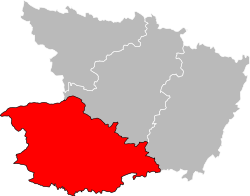 Location of the arrondissement in Maine-et-Loire | |
| Country | France |
| Region | Pays de la Loire |
| Department | Maine-et-Loire |
| Communes | 32 |
| Subprefecture | Cholet |
| Area¹ | |
| • Total | 2,103 km2 (812 sq mi) |
| Population (2013) | |
| • Total | 203,287 |
| • Density | 97/km2 (250/sq mi) |
| ¹ French Land Register data, which exclude lakes, ponds, and glaciers larger than 1 km² as well as the estuaries of rivers. | |
The arrondissement of Cholet is an arrondissement of France in the Maine-et-Loire department in the Pays de la Loire region. Since the January 2017 reorganization of the arrondissements of Maine-et-Loire, it has 32 communes.[1]
Composition
Cantons
The cantons of the arrondissement of Cholet are:
Communes
The communes of the arrondissement of Cholet, and their INSEE codes, are:
- Beaupréau-en-Mauges (49023)
- Bégrolles-en-Mauges (49027)
- Cernusson (49057)
- Les Cerqueux (49058)
- Chanteloup-les-Bois (49070)
- Chemillé-en-Anjou (49092)
- Cholet (49099)
- Cléré-sur-Layon (49102)
- Coron (49109)
- Lys-Haut-Layon (49373)
- Mauges-sur-Loire (49244)
- Maulévrier (49192)
- Le May-sur-Èvre (49193)
- Mazières-en-Mauges (49195)
- Montilliers (49211)
- Montrevault-sur-Èvre (49218)
- Nuaillé (49231)
- Orée-d'Anjou (49069)
- Passavant-sur-Layon (49236)
- La Plaine (49240)
- La Romagne (49260)
- Saint-Christophe-du-Bois (49269)
- Saint-Léger-sous-Cholet (49299)
- Saint-Paul-du-Bois (49310)
- La Séguinière (49332)
- Sèvremoine (49301)
- Somloire (49336)
- La Tessoualle (49343)
- Toutlemonde (49352)
- Trémentines (49355)
- Vezins (49371)
- Yzernay (49381)
References
- ↑ "Arrêté préfectoral, 27 December 2016" (PDF). Retrieved 2017-08-04.
External links
This article is issued from
Wikipedia.
The text is licensed under Creative Commons - Attribution - Sharealike.
Additional terms may apply for the media files.