Cattai, New South Wales
| Cattai Sydney, New South Wales | |||||||||||||||
|---|---|---|---|---|---|---|---|---|---|---|---|---|---|---|---|
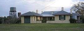 Arndell's cottage | |||||||||||||||
|
Cattai | |||||||||||||||
| Coordinates | 33°33′22″S 150°54′43″E / 33.55611°S 150.91194°ECoordinates: 33°33′22″S 150°54′43″E / 33.55611°S 150.91194°E | ||||||||||||||
| Population |
| ||||||||||||||
| Postcode(s) | 2756 | ||||||||||||||
| Location | 63 km (39 mi) north-west of Sydney CBD | ||||||||||||||
| LGA(s) | |||||||||||||||
| State electorate(s) | Hawkesbury | ||||||||||||||
| Federal Division(s) | |||||||||||||||
| |||||||||||||||
Cattai is a suburb of Sydney, in the state of New South Wales, Australia. Cattai is located 63 kilometres north-west of the Sydney central business district in the local government areas of The Hills Shire and City of Hawkesbury.[3]
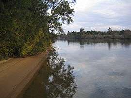
Cattai is bounded in the north-west by the Hawkesbury River and is traversed by Cattai Creek to its confluence with the river. Apart from the natural endowments of the area, one of the outstanding landmarks is the brick farmhouse known as Cad-Die, located at the junction of Cattai Creek and the Hawkesbury River. This Georgian house was built in 1821 by Thomas Arndell, with further additions being made in the 1860s. It is now listed on the Register of the National Estate.[4]
Demographics
Race and religion
The majority of people from Cattai were born in Australia (85.0%), with 66.3% having both parents being born within Australia.[5]
In 2016, the most prevalent religion in Cattai was Anglican (28.0%).[5] Catholicism was the second most prevalent religion (24.5%).[5] In 2011more than 70% of the area identified as Christian.[6] A large majority of the population was born within Australia (84.4%), followed by those born in England (4.7%).[7]
Languages spoken
According to the 2016 National Census, 8.9% of people from Cattai spoke a language other than English at home. The second most spoken language was Urdu.[5]
Age
More than 30% of Cattai's residents are between the age of 40 and 59.[6] Cattai's median age is 42.[8]
Wealth
41.4% of the population own their home, and the Median household income is $1,718 per week, which is $481 higher than the state average.[9] Cattai was ranked the 272nd most expensive suburb of NSW in 2015.[10]
63.2% of the people living in Cattai over the age of 15 and who identify as being in the labour force are employed full-time, 26.7% are working on a part-time basis. Cattai has an unemployment rate of 5.0%.[9]
Education and employment
More than 40% of the population completed year 12 or equivalent.[11]
History
The name of the town, 'Cattai', is derived from an Aboriginal word with an unknown meaning. The First Fleet Assistant Surgeon, Thomas Arndell, built a homestead which resides in the now named Cattai National Park.[12]
Cattai Post Office opened on 26 November 1906 and closed in 1994.[13]
Cattai Public School was established in 1886, and is situated in the Hills District of Sydney, Australia.[14] Arndell Anglican College was originally established in Cattai in 1990, until it moved to its current site of Oakville in 1994.[15]
Heritage listings
Cattai has a number of heritage-listed sites, including:
- Wisemans Ferry Road: Cattai Estate[16]
Landmarks
Parks and recreation
- Thomas Arndell's Cottage
- Cattai National Park
- Mitchell Park
Education Facilities
- Cattai Primary School is located on 487 Cattai Rd, Cattai, and 'is a happy and safe rural school' that 'overlooks the Cattai Creek in a picturesque setting.' Campus facilities;
- 4 classrooms with interactive whiteboards
- Computers, including a specialised computer room with access to the internet and classes that allow for more individualised tuition
- School Library
- 1 Administration Building
- An upgraded playground with rubber based Soft Fall and mini goal posts for students use
- Sports oval, with complementary large grass areas
- Arndell Anglican College was originally established in 1990 at Threlked Drive, Cattai. It has since been relocated to Oakville, New South Wales. The school is of Anglican denomination.
Other
- Riverside Oaks Golf Resort
- Hawkesbury River
- Cattai Joinery
See also
References
- ↑ Australian Bureau of Statistics (27 June 2017). "Cattai". 2016 Census QuickStats.

- ↑ Australian Bureau of Statistics (31 October 2012). "Cattai". 2011 Census QuickStats.
- ↑ Gregory's Sydney Street Directory, Gregory's Publishing Company, 2007
- ↑ The Heritage of Australia, Macmillan Company, 1981, p. 2/12
- 1 2 3 4 "2016 Census QuickStats: Cattai". www.censusdata.abs.gov.au. Retrieved 2017-11-06.
- 1 2 "Suburb Demographics for Cattai(2756) New South Wales - Myboot.com.au". myboot.com.au. Retrieved 2017-11-06.
- ↑ "Cattai Demographics (NSW) Local Stats". cattai.localstats.com.au. Retrieved 2017-11-06.
- ↑ "Cattai Suburb Profile & Demographics | propertyDATA.com.au". www.realestateview.com.au. Retrieved 2017-11-06.
- 1 2 "Cattai Demographics (NSW) Local Stats". cattai.localstats.com.au. Retrieved 2017-11-06.
- ↑ "Propert Value of Cattai".
- ↑ "Suburb Demographics for Cattai(2756) New South Wales - Myboot.com.au". myboot.com.au. Retrieved 2017-11-06.
- ↑ McHardy, Cathy. "Baulkham Hills City Council Origin of Suburb Names". Hawkesbury.org. 300 Purple Toasters. Retrieved 6 December 2016.
- ↑ Premier Postal History. "Post Office List". Retrieved 1 June 2012.
- ↑ Cattai Public School. "About Us". Cattai Public School. Retrieved 6 December 2016.
- ↑ Arndell Anglican College. "History and Culture". arndell.nsw.edu.au. Retrieved 6 December 2016.
- ↑ "Cattai Estate, New South Wales State Heritage Register (NSW SHR) Number H00982". New South Wales State Heritage Register. Office of Environment and Heritage. Retrieved 18 May 2018.