Northmead, New South Wales
| Northmead Sydney, New South Wales | |||||||||||||||
|---|---|---|---|---|---|---|---|---|---|---|---|---|---|---|---|
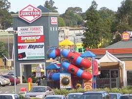 The Junction, Windsor Road | |||||||||||||||
|
Northmead | |||||||||||||||
| Coordinates | 33°46′54″S 151°0′8″E / 33.78167°S 151.00222°ECoordinates: 33°46′54″S 151°0′8″E / 33.78167°S 151.00222°E | ||||||||||||||
| Population | 11,215 (2016 census)[1] | ||||||||||||||
| • Density | 2,608/km2 (6,760/sq mi) | ||||||||||||||
| Postcode(s) | 2152 | ||||||||||||||
| Area | 4.3 km2 (1.7 sq mi) | ||||||||||||||
| Location | 26 km (16 mi) west of Sydney CBD | ||||||||||||||
| LGA(s) | City of Parramatta | ||||||||||||||
| State electorate(s) | Seven Hills | ||||||||||||||
| Federal Division(s) | Parramatta | ||||||||||||||
| |||||||||||||||
Northmead is a suburb of Sydney, in the state of New South Wales, Australia. Northmead is located 26 kilometres west of the Sydney central business district, in the local government area of the City of Parramatta. Northmead is part of the Greater Western Sydney region.
Northmead is a hilly suburb with low to medium density houses, townhouses and apartment buildings, and a large light industrial area. It is located to the northeast of the junction of Darling Mills Creek and Toongabbie Creek, which combine to form the beginnings of the Parramatta River.
History
With the British settlement of Parramatta, this area was originally part of the domain of Government House. What is left of this domain, including Government House, forms Parramatta Park. The name Northmead is derived from the location of the north "mead", or meadow, of the governor's domain.[2] The land was subdivided between 1859 and 1889 and the Northern Meadow and Western Meadow of the domain were split off and called Northmead and Westmead. From this time, orchards were established by many new settlers, including some whose names were well known in the Parramatta area - George Oakes, Nat Payten and William Fullagar among them.
Heritage listings
Northmead has a number of heritage-listed sites, including:
- 226 (rear) Windsor Road: Northmead European rock carvings[3]
Commercial areas
- Commercial Area 1: Northmead Shopping Centre is located at 2 Campbell St, corner of Windsor Road, and features an IGA supermarket and many specialty shops. Specialty shops include Thai take away restaurant, medical centre, florist, deli, butcher, bakery, dry cleaners, chemist, fruit & veg, and a Chinese restaurant with $7.50 lunch special on weekdays. The centre is managed by PRD Nationwide in Bondi Junction.
- Commercial Area 2: The Junction shops are located on the corner of Windsor Road and Briens Road and features a number of retailers for home furnishings, hardware, car accessories (Supercheap Auto, Repco), office supplies and electricals Office Works and food outlets Subway, Hungry Jack's, Winning Appliances and Hog's Breath.
- Commercial Area 3: Corner of Kleins st and Briens rd. Featuring a bottle market, a bakery, Domnio's Pizza , a dental practice and a mini convenience shop.
Industrial area
Northmead is the home of a large number of light industires, especially around Briens Road which runs along the back of the Westmead Hospital district. Along Briens Road are:
- Coca-Cola Amatil bottles Coca-Cola and other softdrink
- Australian Paper
- Ontera Carpets
On Boundary Road, there is a bus depot for Hillsbus which is the Region 4 bus operator.
Schools
- Northmead Public School - Moxhams Road.
- Northmead High School - Campbell Street.
- The Hills School - William Street.
Transport
The North West T-Way connecting the Hills with Parramatta runs through Northmead. Northmead's public transport needs are only catered by buses, namely those of the Hillsbus bus company. This results in highly operational bus services in the Hills District - an area that is one of the fastest growing in Australia.
The major roads are Windsor Road and the Cumberland Highway.
Transport history
Northmead once featured a train line known as the Rogans Hill railway line. Long underperforming due to an increasing preference for faster and more modern motor buses, it was decided in 1929[4] under conservative (United Australia Party) Premier Bertram Stevens that the line should be decommissioned, which eventually took place on 31 January 1932.
Currently, there is no train line that services Northmead with the closest being the Main Western Railway Line that runs through Westmead and Parramatta.
Population
According to the 2016 census conducted by the Australian Bureau of Statistics, Northmead had a population of 11,215.[1] This was a significant increase from the 2006 census, which showed a population of 6,969.[5] This increase went hand in hand with an increase in apartments in the suburb from 9.9% to 32.4% over the period.[1][5]
61.1% of people were born in Australia. The most common countries of birth were India 4.7%, China 3.4%, England 2.1%, Iran 2.1% and Philippines 1.9%. 63.1% of people only spoke English at home. Other languages spoken at home included Mandarin 3.4%, Arabic 2.8%, Cantonese 2.5%, Persian 2.2% and Korean 2.1%. The religious affiliation responses were Catholic (27.5%), No Religion 20.6% and Anglican (13.6%).[1]
Notable residents
- Parramatta City Councillor, Former Lord Mayor Scott Lloyd was raised in Northmead, and went to Northmead primary school between 1983 and 1989.
- Richie Benaud (1930-2015), cricketer and commentator.
- Allan Cunningham (1791–1839), explorer and botanist.
- Harry Hopman (1906–1985), tennis player.
- David Lennox (1788–1873), colonial bridge builder.
- John Lewin (1770–1819), first professional artist in New South Wales.
- Rev. Samuel Marsden (1765–1838), known as the "flogging parson".
- Mary Cover Hassall (1799–1825), Methodist missionary to Tonga Island.
- Dowell Philip O'Reilly (1865–1923), poet and politician.
References
- 1 2 3 4 Australian Bureau of Statistics (27 June 2017). "Northmead (State Suburb)". 2016 Census QuickStats. Retrieved 15 July 2017.

- ↑ "History of Northmead". hillsdirectory.com.au. Retrieved 11 February 2010.
- ↑ "European Rock carvings, New South Wales State Heritage Register (NSW SHR) Number H00680". New South Wales State Heritage Register. Office of Environment and Heritage. Retrieved 18 May 2018.
- ↑ "STATE SESSION. Temporary Supply". Sydney Morning Herald. 25 September 1929. Retrieved 22 April 2013.
- 1 2 Australian Bureau of Statistics (25 October 2007). "Northmead (State Suburb)". 2006 Census QuickStats. Retrieved 24 April 2015.
| Wikimedia Commons has media related to Northmead, New South Wales. |