Carnedd Llewelyn
| Carnedd Llewelyn | |
|---|---|
 | |
| Highest point | |
| Elevation | 1,064 m (3,491 ft) |
| Prominence | 750 m (2,460 ft) |
| Parent peak | Snowdon |
| Listing | Marilyn, Hewitt, Welsh 3000s, council top, Nuttall |
| Naming | |
| Translation | Llywelyn's cairn (Welsh) |
| Pronunciation | Welsh: [ˈkarnɛð ɬəˈwɛlɨn] |
| Geography | |
| Location | Gwynedd / Conwy, UK |
| Parent range | Snowdonia |
| OS grid | SH683644 |
| Topo map | OS Landranger 115, Explorer OL17 |
| Climbing | |
| Easiest route | Hike |
| Listed summits of Carnedd Llewelyn | ||||
| Name | Grid ref | Height | Status | |
|---|---|---|---|---|
| Carnedd Dafydd | SH663630 | 1,044 m (3,425 ft) | 3, H, N | |
| Pen yr Ole Wen | SH655619 | 978 m (3,209 ft) | 3, H, N | |
| Foel Grach | SH688658 | 976 m (3,202 ft) | 3, H, N | |
| Yr Elen | SH673651 | 962 m (3,156 ft) | 3, H, N | |
| Foel-fras | SH696681 | 942 m (3,091 ft) | 3, H, N | |
| Garnedd Uchaf | SH687669 | 926 m (3,038 ft) | 3, H, N | |
| Llwytmor | SH689692 | 849 m (2,785 ft) | H, N | |
| Pen yr Helgi Du | SH698630 | 833 m (2,733 ft) | H, N | |
| Bera Mawr | SH674682 | 794 m (2,605 ft) | H, N | |
| Drum | SH708695 | 770 m (2,530 ft) | H, N | |
| Drosgl | SH664679 | 758 m (2,487 ft) | H, N | |
Carnedd Llewelyn, usually spelt Carnedd Llywelyn in Welsh, is a mountain massif in the Carneddau range in Snowdonia, north-west Wales. It is the highest point of the Carneddau and the second highest peak by relative height in Wales, 49th in the British Isles and lies on the border between Gwynedd and Conwy.[1]
Topography and ascent routes
Carnedd Llewelyn lies in the middle of the main north-east to south-west ridge of the Carneddau, between Carnedd Dafydd to the south-west and Foel Grach to the north. A short subsidiary ridge links it to Yr Elen to the north-west. Its position means that any route to this summit involves a long walk, and it is regarded as the most difficult ascent in the British Isles. It can be climbed from Gerlan, above Bethesda, taking the path following Afon Llafar then continuing to the summit of Yr Elen before following the short ridge to Carnedd Llewelyn. Another path starts from Helyg on the A5, taking the track to the reservoir then following the slopes above Craig yr Ysfa to the summit. An alternative is to reach it by following the main ridge, either from Pen yr Ole Wen or from Foel-fras.
The summit is a flat, boulder-strewn plateau, similar to several of the other mountains that lie in the southern Carneddau. The cliffs below the ridges are well-known rock climbs, notably Ysgolion Duon (meaning "black ladders") and Craig yr Ysfa. The flat plateau means that during winter and spring, significant accumulations of snow and blizzards occur on frequent occasions. The mountain has also been noted for its long-lying snow patches in recent years, with old snow patches known to survive on its southern gullies well into July. The highest lake in Wales, Llyn Llyffant lies to the lee of the summit of Carnedd Llywelyn.[2]
Name
Carnedd Llywelyn means "Llywelyn's cairn" in Welsh. It is widely believed that Carnedd Llewelyn and the neighbouring Carnedd Dafydd are named after Llywelyn ap Gruffudd and his brother Dafydd ap Gruffudd, the last independent prince of Wales, respectively.[3] An alternative theory is that the twin peaks are named after Llywelyn the Great, an earlier prince of Gwynedd, and his son and successor, Dafydd ap Llywelyn.[4][5] Other sources cite a combination of the above, i.e. Llywelyn the Great and Dafydd ap Gruffudd.[6]
The spelling of the name is also controversial. Carnedd Llewelyn is the form used by the Ordnance Survey, the mapping agency for Great Britain, and other sources.[7] In Wales the spelling Carnedd Llywelyn predominates (it is used on the website of the Snowdonia National Park Authority, for example[8]); this is also the form preferred by most Welsh writers, among others.[9] Many authoritative works, from other study groups, also use the Welsh form.[10] The Welsh personal name Llywelyn, from which the mountain's name is derived, is always spelt thus in the Welsh language, although the forms Llewelyn and Llewellyn are found in older English-language sources.
Cultural references
The mountain features in Welsh poetry and literature; the earliest known work is a poem by Rhys Goch Eryri, Carnedd Llywelyn, composed c. 1400.
Notes
- ↑ Dawson, Alan (1997). The Hewitts and Marilyns of Wales. Cambuskenneth, Stirling: TACit Press. ISBN 0-9522680-6-X. Archived from the original on 2006-12-05.
- ↑ https://www.geograph.org.uk/photo/910130
- ↑ Edmund Vale (editor) (1958). Snowdonia National Park Guide. HMSO.
- ↑ Nuttall, John & Anne (1999). The Mountains of England & Wales – Volume 1: Wales (2nd ed.). Milnthorpe, Cumbria: Cicerone. ISBN 1-85284-304-7.
- ↑ R. F. Walker; et al. (1972). "Hubert de Burgh and Wales, 1218–1232". The English Historical Review: 466–494.
- ↑ Carr & Lister (1925). The Mountains of Snowdonia. London: Lockwood Press.
- ↑ For example, John and Anne Nuttall, The Hewitts and Marilyns of Wales, cited above; or Irvine Butterfield, The High Mountains of Britain and Ireland (Diadem, 1986).
- ↑ Snowdonia National Park Authority: Snowdonia's Mountains Archived October 24, 2014, at the Wayback Machine.
- ↑ For example, Dewi Tomos, Eryri (Gwasg Carreg Gwalch, 2005); Colin Marsh, The Mountain Walker's Guide to Wales (Gwasg Carreg Gwalch, 2002); or Harvey Superwalker Waterproof Map, Snowdonia, the Glyderau and the Carneddau (Harvey Maps, 2003).
- ↑ G. H. Howe & P. Thomas, Welsh Landforms & Scenery (Macmillan, 1963); Physical Names for the Map of Britain: Discussion (The Geographical Journal (102), 1943); or M. O. Hill, D. F. Evans & S. A. Bell, Long Term Effect of Excluding Sheep from Hill Pastures in North Wales (The Journal of Ecology (80), 1992).
Further reading
- Adams, Colin (2002). The Mountain Walker's Guide to Wales. Gwasg Carreg Gwalch. ISBN 0-86381-725-4.
- Rees, Ioan Bowen (1995). The Mountains of Wales: an anthology in verse and prose. University of Wales Press. ISBN 978-0-7083-1163-9.
- Tomos, Dewi (2005). Eryri. Gwasg Carreg Gwalch. ISBN 0-86381-994-X.
- Lowe, W. Bezant (1927). The heart of Northern Wales: Vol. II.
- Roberts, Geraint (1995). The Lakes of Eryri. Gwasg Carreg Gwalch. ISBN 0-86381-338-0.
- Royal Commission on Ancient Monuments Wales (1956). Caernarvonshire, Volume 1: East.
External links
| Wikimedia Commons has media related to Carnedd Llywelyn. |
- Carnedd Llewelyn is at coordinates 53°09′38″N 3°58′09″W / 53.160587°N 3.969305°WCoordinates: 53°09′38″N 3°58′09″W / 53.160587°N 3.969305°W
- Walking Routes, photos and GPS files for Carnedd Llewelyn Walk Eryri
- www.geograph.co.uk : photos of Carnedd Llewelyn
| Northern Highlands | 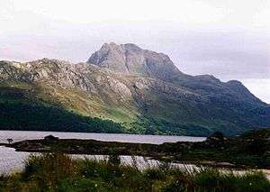 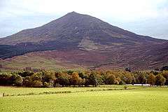 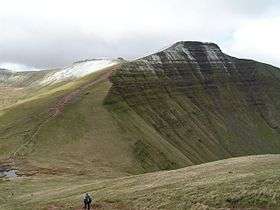 | |
|---|---|---|
| Western Highlands | ||
| Central and Eastern Highlands | ||
| Southern Highlands | ||
| Islands | ||
| Scottish Lowlands, England and Wales | ||