Beinn Sgulaird
| Beinn Sgulaird (Meg's Mountain) | |
|---|---|
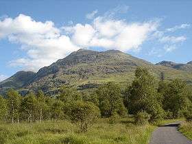 Beinn Sgulaird from the road to Glen Ure House to the west | |
| Highest point | |
| Elevation | 937 m (3,074 ft) [1] |
| Prominence | 662 m (2,172 ft) |
| Listing | Munro, Marilyn |
| Naming | |
| Pronunciation |
Scottish Gaelic: [ˈpeɲ ˈs̪kul̪ˠərˠtʲ] English approximation: bayn-SKOO-lərt-yə |
| Geography | |
| Location | Argyll and Bute, Scotland |
| OS grid | NN053460 |
| Topo map | OS Landranger 50, OS Explorer 377 |
| Climbing | |
| Easiest route | walk |
Beinn Sgulaird is a Scottish mountain located between Glen Creran and Glen Etive in the southern highlands. It has a height of 937 m (3074 ft) and is classed as a Munro. The mountain takes the form of a long ridge which runs from southwest to northeast, three kilometres of which lie above 800 m.[2] Hillwalkers commonly traverse the ridge from north to south, as this gives the best views of the Hebrides to the west, in particular the Isle of Mull.[3] While most walkers start from Glen Creran to the west, an ascent from Glen Etive is also possible.[4]
References
- ↑ "walkhighlands Beinn Sgulaird". walkhighlands.co.uk. 2013. Retrieved 2 November 2013.
- ↑ The Munros (SMC Guide), Donald Bennett et al., ISBN 0-907521-13-4
- ↑ The Munros: Scotland's Highest Mountains, Cameron McNeish, ISBN 0-947782-50-8
- ↑ Hats off to the deceptive Beinn Sgulaird, Robin Howie, The Scotsman, 22 October 2005
 |
|  | |
| Northern Highlands |   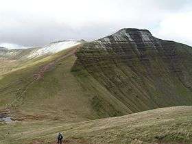 | |
|---|---|---|
| Western Highlands | ||
| Central and Eastern Highlands | ||
| Southern Highlands | ||
| Islands | ||
| Scottish Lowlands, England and Wales | ||
Coordinates: 56°33′58″N 5°10′06″W / 56.566085°N 5.168387°W
This article is issued from
Wikipedia.
The text is licensed under Creative Commons - Attribution - Sharealike.
Additional terms may apply for the media files.