Gaor Bheinn
| Gaor Bheinn | |
|---|---|
 | |
| Highest point | |
| Elevation | 987 m (3,238 ft) [1] |
| Prominence | 842 m (2,762 ft) Ranked 23rd in British Isles |
| Parent peak | Carn Eige |
| Listing | Munro, Marilyn |
| Naming | |
| Translation | dirty hill or noisy hill (Gaelic) |
| Pronunciation | Scottish Gaelic: [ˈkɯːɾveɲ] |
| Geography | |
| Location | Highland, Scotland |
| OS grid | NN002875 |
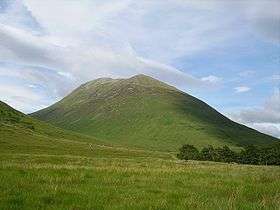
Gaor Bheinn, also known as Gulvain or Culvain, is a mountain in Scotland, to the north of the road west of Fort William (from which it is usually climbed), and south of Loch Arkaig. It is composed of banded granite and shaped like a letter Y, with two tops connected by a ridge running from northeast to southwest, with the northern top 6 m higher than the one to the south. Crags drop at either end, and steep slopes fall away to either side.
The south ridge path is really a stream bed, so in wet conditions an easier if longer ascent from Na Socachan is to walk up Allt a Choire Reidh towards Gualann nan Osna and climb the south top's north-west ridge.
References
- ↑ "www.munromagic.com Gulvain or Gaor Bheinn". MunroMagic.com. Retrieved 22 December 2013.
External links
| Wikimedia Commons has media related to Gaor Bheinn. |
- Gulvain from MunroMagic
Coordinates: 56°56′08″N 5°17′08″W / 56.93553°N 5.28558°W
 |
|  | |
| Northern Highlands |  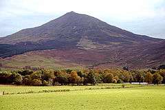 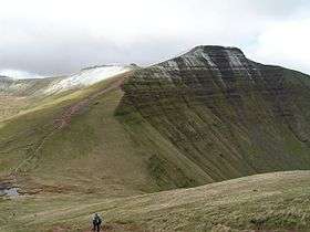 | |
|---|---|---|
| Western Highlands | ||
| Central and Eastern Highlands | ||
| Southern Highlands | ||
| Islands | ||
| Scottish Lowlands, England and Wales | ||
This article is issued from
Wikipedia.
The text is licensed under Creative Commons - Attribution - Sharealike.
Additional terms may apply for the media files.